Interstate 110 and California State Route 110
Template:Short description Template:DMCA Template:DMCA
Page Template:Hlist/styles.css has no content.Page Template:Plainlist/styles.css has no content.Page Module:Infobox/styles.css has no content.Page Template:Infobox road/styles.css has no content.
| Script error: No such module "Infobox road/route". | |
|---|---|
| Lua error in package.lua at line 80: module 'Module:Road data/util' not found. | |
I-110 highlighted in red; SR 110 in purple | |
| Script error: No such module "Infobox mapframe". | |
| Lua error in package.lua at line 80: module 'Module:Road data/util' not found. | |
| Lua error in package.lua at line 80: module 'Module:Road data/util' not found. | |
| Auxiliary route of Lua error in package.lua at line 80: module 'Module:Road data/util' not found. | |
| Lua error in package.lua at line 80: module 'Module:Road data/util' not found. | |
| Lua error in package.lua at line 80: module 'Module:Road data/util' not found. | |
| Length | Lua error: expandTemplate: template "cvt" does not exist. |
| Existed | Lua error in package.lua at line 80: module 'Module:Road data/util' not found. |
| Lua error in package.lua at line 80: module 'Module:Road data/util' not found. | |
| Lua error in package.lua at line 80: module 'Module:Road data/util' not found. | Page Template:Plainlist/styles.css has no content. |
| Tourist routes | File:MUTCD M10-1.svgFile:California Scenic State.svg Arroyo Seco Parkway |
| Restrictions | No trucks over 3 tons north of US 101 |
| Page Template:Plainlist/styles.css has no content.Page Module:Infobox/styles.css has no content.Major junctions | |
| South end | Template:Jct in San Pedro, Los Angeles |
| Page Template:Plainlist/styles.css has no content. | |
| North end | Glenarm Street in Pasadena |
| Lua error: expandTemplate: template "Country name" does not exist. | |
| Lua error in package.lua at line 80: module 'Module:Road data/util' not found. | |
| Script error: No such module "Infobox road/browselinks". | |
| Lua error in package.lua at line 80: module 'Module:Road data/util' not found. | |
| Lua error in package.lua at line 80: module 'Module:Road data/util' not found. | |
Script error: No such module "Infobox road/errors".[[Category:Infobox road instances Template:Infobox road/meta/mask/category]]
Route 110, consisting of State Route 110 (SR 110) and Interstate 110 (I-110), is a state and auxiliary Interstate Highway in the Los Angeles metropolitan area of the US state of California. The entire route connects San Pedro and the Port of Los Angeles with Downtown Los Angeles and Pasadena. The southern segment from San Pedro to I-10 in downtown Los Angeles is signed as I-110, while the northern segment to Pasadena is signed as SR 110. The entire length of I-110, as well as SR 110 south of the Four Level Interchange with US Route 101 (US 101), is the Harbor Freeway,[2] and SR 110 north from US 101 to Pasadena is the historic Arroyo Seco Parkway, the first freeway in the western United States.[3]
Route description
Route 110 is defined as follows in section 410, subdivision (a), of the California Streets and Highways Code:[4]
Route 110 is from Route 47 in San Pedro to Glenarm Street in Pasadena.
Following its renumbering from Route 11, Route 110 was originally defined as "from San Pedro to Colorado Boulevard in Pasadena." The conventional highway portions of the route were relinquished to the cities of Pasadena and Los Angeles in 2000 and 2009 respectively.[5] However, section 410, subdivision (b) further mandates that those cities with those relinquished former portions must still "maintain within their respective jurisdictions signs directing motorists to the continuation of Route 110".[4]
Only the southern 20.34-mile (32.73 km) segment of Route 110 is considered an Interstate Highway according to the Federal Highway Administration (FHWA)'s route logs.[6][7]
Route 110 is part of the California Freeway and Expressway System,[8] and is part of the National Highway System,[6] a network of highways that are considered essential to the country's economy, defense, and mobility by the Federal Highway Administration.[9]
-
Entering Interstate 110 in Harbor Gateway, Los Angeles
-
The Harbor Freeway is often heavily congested at rush hour.
-
Entrance to the Harbor Freeway in Downtown Los Angeles
-
The Harbor Freeway southbound entering "The Slot" after emerging from the "4-level"
Harbor Freeway
Lua error in package.lua at line 80: module 'Module:Hatnote list' not found.
The Harbor Freeway, signed as I-110, begins at Gaffey Street in San Pedro, where it then travels mostly due north to the Santa Monica Freeway (I-10) at a point south of downtown Los Angeles, where it becomes signed as SR 110. I-110 is primarily within the city limits of Los Angeles, running right along the South Los Angeles region and the Harbor Gateway, a two-mile (3.2 km) wide north–south corridor that was annexed by the city of Los Angeles specifically to connect San Pedro, Wilmington, and the Port of Los Angeles with the rest the city.
North of I-10, the freeway continues as SR 110 through Downtown Los Angeles to its junction with US 101 at the Four Level Interchange.
The Harbor Freeway, along with the Long Beach Freeway (I-710), are the principal means for freight from the Port of Los Angeles to railyards and warehouses further inland. Its interchange with the Santa Monica Freeway is notoriously busy and congested, and the portions bordering Bunker Hill in northwest Downtown Los Angeles are choked with traffic at peak travel times.
- Landmarks
Notable landmarks and attractions near the Harbor Freeway include the Los Angeles Harbor College, California State University, Dominguez Hills, Watts Towers, Exposition Park (including the Los Angeles Memorial Coliseum, the BMO Stadium and the Lucas Museum of Narrative Art), the University of Southern California, Crypto.com Arena, L.A. Live, Los Angeles Convention Center, the skyline of Downtown Los Angeles; and Chinatown.
The Harbor Freeway is noted for its elaborate high-occupancy toll lane feature, with the HOT lanes elevated above the rest of traffic in many areas, constructed in 1994 by C.C. Myers, Inc. as HOV lanes and converted to HOT lanes in 2012. Of particular note is the Judge Harry Pregerson Interchange, which contains the most elaborate network of direct HOV/HOT connectors in Los Angeles County. It includes a seven-story ramp that connects the Century Freeway's HOV lanes to the Harbor Freeway's northbound HOT lanes and offers splendid views of the entire Los Angeles Basin and the San Gabriel Mountains. The interchange with SR 91 (formally known as the Edmond J. Russ Interchange) is also fairly large.
Arroyo Seco Parkway
Script error: No such module "Labelled list hatnote".
SR 110 continues north as the Arroyo Seco Parkway from US 101 to Pasadena. From downtown, it passes through Elysian Park, where the northbound lanes pass through the four Figueroa Street Tunnels and the higher southbound lanes pass through a cut and over low areas on bridges. Then after crossing the Los Angeles River and the Golden State Freeway (I-5), the parkway runs alongside the Arroyo Seco seasonal river towards Pasadena.
Harbor Transitway
The Harbor Transitway is a grade-separated, shared-use express bus and high-occupancy toll (HOT) corridor, running in the median of I-110, between SR 91 (Gardena Freeway) and Adams Boulevard in the south side of Downtown Los Angeles. The southern end of the HOT lanes also includes dedicated ramps connecting to the Harbor Gateway Transit Center.
As of January 2026[update], the high-occupancy toll (HOT) lanes are a 24/7 service. Solo drivers are tolled using a congestion pricing system based on the real-time levels of traffic. Carpools with two or more people and motorcycles are not charged. All tolls are collected using an open road tolling system, and therefore there are no toll booths to receive cash. Each vehicle using the HOT lanes is required to carry a FasTrak Flex transponder with its switch set to indicate the number of the vehicle's occupants (1, 2, or 3+). Solo drivers may also use the FasTrak standard tag without the switch. Drivers without any FasTrak tag will be assessed a toll violation regardless of whether they qualified for free.[10]
History
Script error: No such module "Labelled list hatnote".
Page Template:Infobox road/styles.css has no content.Page Module:Infobox/styles.css has no content.
| Script error: No such module "Infobox road/route". | |
|---|---|
| <div class="Lua error in package.lua at line 80: module 'Module:Road data/util' not found." style="margin:0; height:.5em;"> | |
| Location | San Pedro - Pasadena |
| Existed | 1934–1981 |
Script error: No such module "Check for conflicting parameters".
In the 1924 Major Street Traffic Plan for Los Angeles, a widening of Figueroa Street to San Pedro as a good road to the Port of Los Angeles was proposed.[11] Progress was slow,[12] and, in 1933, the state legislature added the entire length to the state highway system as Route 165, an unsigned designation. This route not only extended from San Pedro north to Los Angeles, but continued through the city-built Figueroa Street Tunnels and along the northern extension of Figueroa Street to Eagle Rock, and then followed Linda Vista Avenue (via an overlap on Route 161 (SR 134) over the Colorado Street Bridge) to Route 9 (now I-210) at the Devil's Gate Reservoir.[13][14][15] The entire length of Route 165 became Sign Route 11 in 1934.[16] US Route 6 was also assigned to the portion between SR 1 and Avenue 26 in 1937,[17] and, at about the same time, US 66 was moved from Eagle Rock Boulevard to Figueroa Street, overlapping SR 11 between Sunset Boulevard (US 101) and Colorado Street (SR 134).[18][19]
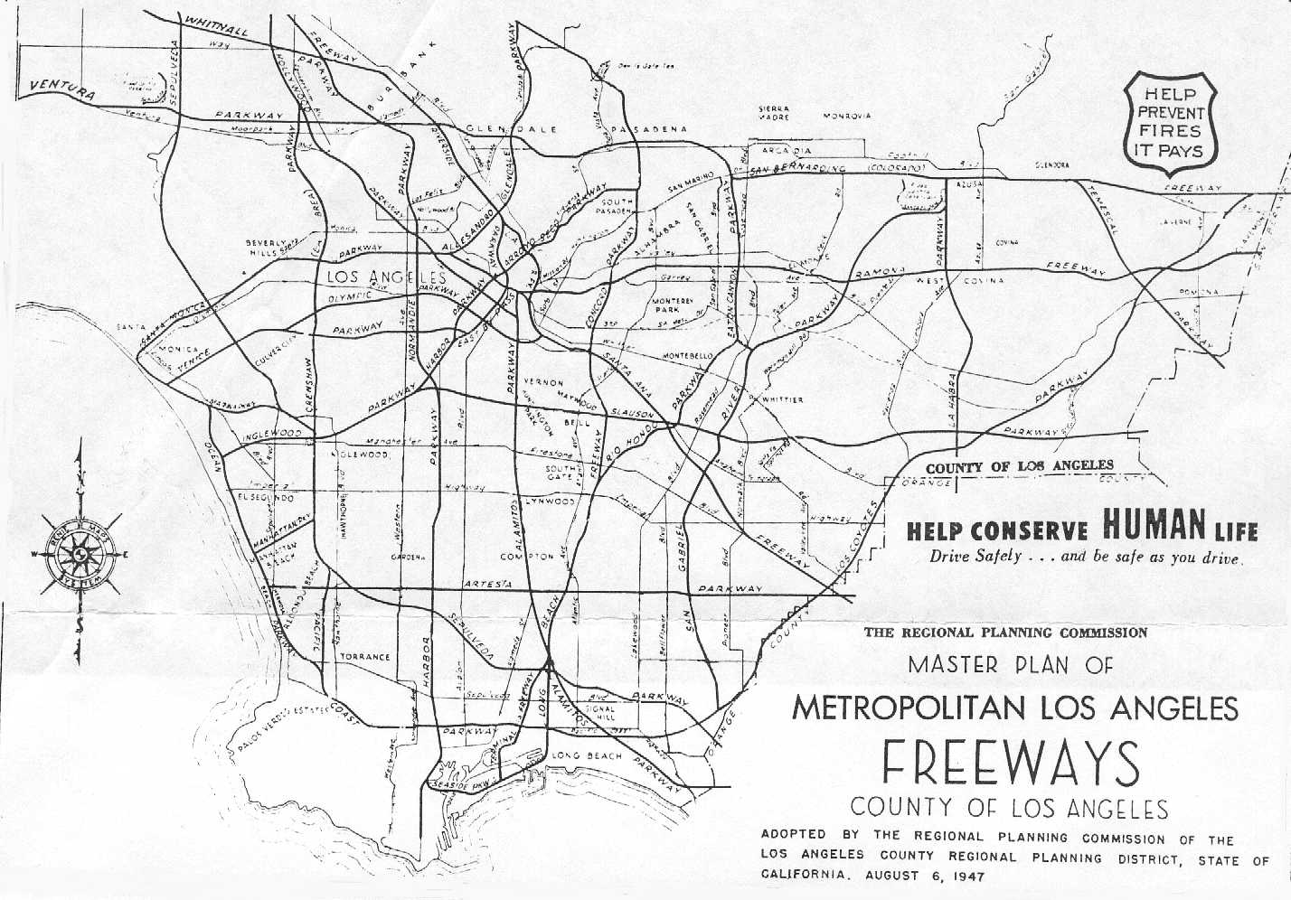
The state completed the Arroyo Seco Parkway which had been added to the state highway system in 1935 as Route 205, in early 1941, providing a faster route between SR 11 at Avenue 26 and Pasadena.[20] US 66 was moved to the new route, while SR 11 remained on Figueroa Street and Linda Vista Avenue, the former also becoming a new US Route 66 Alternate.[21] Construction of a freeway to San Pedro was much slower, despite having been in the earliest plans for an integrated system. Initially, the Harbor Parkway was to split at the merge with the Venice Parkway northeast of the University of Southern California, with the East By-Pass and West By-Pass straddling the Los Angeles Central Business District and rejoining at the split between the Arroyo Seco Parkway and Riverside Parkway south of Dodger Stadium.[22][23][24] The West By-Pass was soon incorporated into the Harbor Parkway,[25] and the first short piece, by then renamed the Harbor Freeway, opened on July 30, 1952, from the Four Level Interchange south to 3rd Street.[26] (The Arroyo Seco Parkway was completed to the Four Level Interchange on September 22, 1953, and renamed the Pasadena Freeway on November 16, 1954.[20])
The Harbor Freeway gradually pushed south, opening to Olympic Boulevard on March 23, 1954,[27] and Washington Boulevard on May 14, 1954.[28] On March 27, 1956, the highway was extended to 42nd Street,[29] and on April 24, 1957, it reached temporary[30] ramps at 88th Place.[31] Further extensions were made to Century Boulevard on July 31, 1958,[32] 124th Street on September 24, 1958,[33] Alondra Boulevard (which the county widened to carry the load) on May 2, 1960,[34] 190th Street on July 15, 1960,[35] Torrance Boulevard on August 28, 1962,[36] and finally Pacific Coast Highway (SR 1) on September 26, 1962.[37] There it connected with a section that had been open since June 19, 1956, from Pacific Coast Highway south to Channel Street.[38] Along with the Vincent Thomas Bridge to Terminal Island, the final piece in San Pedro opened on July 9, 1970, completing the Harbor Freeway to its present length.[39][40][41]
In December 1978, the Harbor Freeway was approved as an Interstate Highway by the FHWA. In 1981, the SR 11 designation was renumbered as I-110 on the Harbor Freeway, and SR 110 on the Pasadena Freeway.[42] The I-110 designation had been previously applied to what is now a spur of I-10 from 1958 to 1968.
Richard Ankrom signage
In 2001, Richard Ankrom, a local artist who got lost trying to get onto I-5 North from northbound SR 110 because there was no clear official signage labeling access to I-5 North, solved his frustration by covertly modifying one of the overhead signs on the freeway just before the Four Level Interchange (Lua error: callParserFunction: function "#coordinates" was not found.). Using official government sign specifications, Ankrom fabricated two sign pieces, one being an I-5 marker shield and the other with the word "NORTH", and affixed them to the left side of the sign. He performed his modifications in broad daylight, disguised as a Caltrans worker. In that district, Caltrans has three sign crews, each thinking one of the other two crews did the installation. After nine months, at Ankrom's request, the Los Angeles Downtown News broke the story.[43]
Prior to Ankrom's work, the only signage directing motorists to the I-5 North off-ramp came at a quarter-mile (0.4 km) before the exit, thus forcing many to merge across multiple lanes in a very short distance. The signs were inspected by Caltrans to ensure they would not fall off onto the road below. Ankrom was never charged, despite statements from officials that his actions were illegal. Ankrom referred to his sign project as "Guerilla Public Service".[44]
Caltrans later added an additional "5 North" sign over the left northbound lane at the entrance to the Figueroa Street Tunnels, as well as new electric signage, which will note when an additional lane is available for those wishing to transition to northbound I-5 (converting the current single lane transition to dual lanes).[<span title="Script error: No such module "decodeEncode".">citation needed]
In 2009, Caltrans replaced all signage along this segment with newer, more reflective versions. These new signs include Ankrom's original improvements.[45][46]
Preservation
Despite the increased traffic in Los Angeles, including trucks shipping products from the Port of Los Angeles in San Pedro, there are no plans to upgrade the rest of I-110 from I-10 to Pasadena to Interstate standards. Instead, Caltrans has pushed for a protected status alternative to preserve the Arroyo Seco Parkway as a historic landmark. The state legislature designated the original section, north of the Figueroa Street Viaduct, as a "California Historic Parkway" (part of the State Scenic Highway System reserved for freeways built before 1945) in 1993;[47] the only other highway so designated is the Cabrillo Freeway (SR 163) in San Diego. The American Society of Civil Engineers named it a National Historic Civil Engineering Landmark in 1999,[48] and it became a National Scenic Byway in 2002.[49]
Exit list
The entire route is in Los Angeles County.
Script error: No such module "Jctint/USA". Script error: No such module "Jctint/USA". Script error: No such module "Jctint/USA". Script error: No such module "Jctint/USA". Script error: No such module "Jctint/USA". Script error: No such module "Jctint/USA". Script error: No such module "Jctint/USA". Script error: No such module "Jctint/USA". Script error: No such module "Jctint/USA". Script error: No such module "Jctint/USA". Script error: No such module "Jctint/USA". Script error: No such module "Jctint/USA". Script error: No such module "Jctint/USA". Script error: No such module "Jctint/USA". Script error: No such module "Jctint/USA". Script error: No such module "Jctint/USA". Script error: No such module "Jctint/USA". Script error: No such module "Jctint/USA". Script error: No such module "Jctint/USA". Script error: No such module "Jctint/USA". Script error: No such module "Jctint/USA". Script error: No such module "Jctint/USA". Script error: No such module "Jctint/USA". Script error: No such module "Jctint/USA". Script error: No such module "Jctint/USA". Script error: No such module "Jctint/USA". Script error: No such module "Jctint/USA". Script error: No such module "Jctint/USA". Script error: No such module "Jctint/USA". Script error: No such module "Jctint/USA". Script error: No such module "Jctint/USA". Script error: No such module "Jctint/USA". Script error: No such module "Jctint/USA". Script error: No such module "Jctint/USA". Script error: No such module "Jctint/USA". Script error: No such module "Jctint/USA". Script error: No such module "Jctint/USA". Script error: No such module "Jctint/USA". Script error: No such module "Jctint/USA". Script error: No such module "Jctint/USA". Script error: No such module "Jctint/USA". Script error: No such module "Jctint/USA". Script error: No such module "Jctint/USA". Script error: No such module "Jctint/USA". Script error: No such module "Jctint/USA". Script error: No such module "Jctint/USA". Script error: No such module "Jctint/USA". Script error: No such module "Jctint/USA". Script error: No such module "Jctint/USA". Script error: No such module "Jctint/USA". Script error: No such module "Jctint/USA". Script error: No such module "Jctint/USA". Script error: No such module "Jctint/USA". Script error: No such module "Jctint/USA". Script error: No such module "Jctint/USA". Script error: No such module "Jctint/USA". Script error: No such module "Jctint/USA". Script error: No such module "Jctint/USA". Script error: No such module "Jctint/USA". Script error: No such module "Jctint/USA". Script error: No such module "Jctint/USA". Script error: No such module "Jctint/USA". Script error: No such module "Jctint/USA". Script error: No such module "Jctint/USA". Script error: No such module "Jctint/USA". Script error: No such module "Jctint/USA".
| Location | mi[1][50][51] | km | Exit[52] | Destinations | Notes |
|---|---|---|---|---|---|
| Page Module:Jctbtm/styles.css has no content.1.000 mi = 1.609 km; 1.000 km = 0.621 mi Page Template:Hlist/styles.css has no content.
| |||||
See also
- Script error: No such module "portal-inline".
- Script error: No such module "portal-inline".
References
Page Template:Reflist/styles.css has no content.
- ^ a b Page Module:Citation/CS1/styles.css has no content.California Department of Transportation. "State Truck Route List". Sacramento: California Department of Transportation. Archived from the original (XLS file) on September 5, 2015. Retrieved June 30, 2015.
- ^ Page Module:Citation/CS1/styles.css has no content.2007 Named Freeways, Highways, Structures and Other Appurtenances in California (PDF). Caltrans. p. 71. Archived from the original (PDF) on October 14, 2012. Retrieved March 27, 2007.
- ^ Page Module:Citation/CS1/styles.css has no content.Ryan, Colin (April 9, 2010). "America's First Freeway: The Arroyo Seco Parkway, aka, the 110". Truck Trend. El Segundo, California: Extreme Venturs, LLC. Retrieved April 10, 2018.
Page Module:Citation/CS1/styles.css has no content."The History of the Arroyo Seco Parkway". Departures. KCET. October 24, 2011. Retrieved April 10, 2010.
Page Module:Citation/CS1/styles.css has no content.Kevin Break (2015). Bridges of Downtown Los Angeles. Arcadia Publishing. p. 94. ISBN 978-1-4671-3353-1.
Page Module:Citation/CS1/styles.css has no content.Johnson, Davey G. (June 29, 2006). "America's First Freeway: The 110". Jalopnik. Gizmodo Media. Retrieved April 10, 2018.
Page Module:Citation/CS1/styles.css has no content.National Park Service's Heritage Education Services. "Arroyo Seco Parkway". Route 66. United States Department of the Interior. Retrieved April 10, 2018.
Page Module:Citation/CS1/styles.css has no content.Sproul, Suzanne (August 28, 2017). "Arroyo Seco Parkway, California's first freeway, celebrates 75 years". Los Angeles Daily News. Retrieved April 10, 2018.The Arroyo Seco Parkway, once called the Pasadena Freeway (110 Freeway) before the name was changed back in 2010, is considered by many to be the first freeway in the state and in the nation.
Page Module:Citation/CS1/styles.css has no content.Rick Thomas (2008). The Arroyo Seco. Arcadia Publishing. ISBN 978-0-7385-5608-6. - ^ a b Page Module:Citation/CS1/styles.css has no content."Section 410". California Streets and Highways Code. Sacramento: California Office of Legislative Counsel. Retrieved August 17, 2025.
- ^ California Highways: www.cahighways.org. Interstate 110.
- ^ a b Page Module:Citation/CS1/styles.css has no content.Federal Highway Administration (March 25, 2015). National Highway System: Los Angeles–Long Beach–Anaheim, CA (PDF) (Map). Scale not given. Washington, DC: Federal Highway Administration. Retrieved October 1, 2017.
- ^ Page Module:Citation/CS1/styles.css has no content."Table 1: Auxiliary Routes of the Dwight D. Eisenhower National System Of Interstate and Defense Highways". FHWA Route Log and Finder List. Federal Highway Administration. January 2025. Retrieved August 17, 2025.
- ^ Page Module:Citation/CS1/styles.css has no content."Article 2 of Chapter 2 of Division 1". California Streets and Highways Code. Sacramento: California Office of Legislative Counsel. Retrieved February 6, 2019.
- ^ Page Module:Citation/CS1/styles.css has no content.Natzke, Stefan; Neathery, Mike & Adderly, Kevin (June 20, 2012). "What is the National Highway System?". National Highway System. Washington, DC: Federal Highway Administration. Retrieved July 1, 2012.
- ^ Page Module:Citation/CS1/styles.css has no content."Using Metro ExpressLanes". www.metroexpresslanes.net. Los Angeles Metro. Retrieved January 1, 2026.
- ^ Los Angeles Times, City Moves in Figueroa Plan, September 29, 1926, p. 13
- ^ Los Angeles Times, Haste Asked on Figueroa, March 2, 1936, p. A8
- ^ Page Module:Citation/CS1/styles.css has no content.California State Assembly. "[[:Template:Cite California statute/titles]]". Fiftieth Session of the Legislature. Statutes of California. State of California. Ch. 767 p. 2040.
{{cite web}}: URL–wikilink conflict (help): "San Pedro to State Highway Route 9 near La Canada via Figueroa Street." - ^ Page Module:Citation/CS1/styles.css has no content.California State Assembly. "[[:Template:Cite California statute/titles]]". Fifty-first Session of the Legislature. Statutes of California. State of California. Ch. 29 p. 285.
{{cite web}}: URL–wikilink conflict (help): "Route 165 is from San Pedro to Route 9 near La Canada via Figueroa Street." - ^ Page Module:Citation/CS1/styles.css has no content.California State Assembly. "[[:Template:Cite California statute/titles]]". Fifty-first Session of the Legislature. Statutes of California. State of California. Ch. 274 p. 959, 285.
{{cite web}}: URL–wikilink conflict (help): "Route 165 is from San Pedro to Route 9 near La Canada via Figueroa Street and Linda Vista Avenue." - ^ Page Module:Citation/CS1/styles.css has no content.Dennis, T.H. (August 1934). "State Routes Will Be Numbered and Marked with Distinctive Bear Signs". California Highways and Public Works. 11 (8): 20–21, 32. ISSN 0008-1159 – via Archive.org.
- ^ Richard F. Weingroff, U.S. 6: The Grand Army of the Republic Highway
- ^ H.M. Gousha Company, Los Angeles and Vicinity, 1935
- ^ H.M. Gousha Company, Los Angeles and Vicinity, 1939
- ^ a b Historic American Engineering Record (J. Philip Gruen and Portia Lee), Arroyo Seco Parkway (HAER No. CA-265) written historical and descriptive data, August 1999, pp. 34, 57, 65, 67 Script error: No such module "webarchive".
- ^ Correspondence between the Division of Highways and American Association of State Highway Officials, transcribed at California Highways: State Route 66
- ^ Automobile Club of Southern California, map from Traffic Survey, Los Angeles Metropolitan Area, 1937, reproduced in Janet L. Abu-Lughod, New York, Chicago, Los Angeles: America's Global Cities, 1999, p. 256
- ^ Transportation Engineering Board, map from A Transit Program for the Los Angeles Metropolitan Region, 1939, reproduced in Gerrylynn K. Roberts, Philip Steadman, American Cities and Technology: Wilderness to Wired City, 1999, p. 79
- ^ Andrew Hamilton, New York Times, Los Angeles Roads Plan, February 25, 1940, p. 128
- ^ Los Angeles County Regional Planning District, Master Plan of Metropolitan Los Angeles Freeways, adopted August 6, 1947
- ^ Los Angeles Times, Official Ceremonies Open First Harbor Freeway Link, July 31, 1952, p. A1
- ^ Los Angeles Times, New Harbor Freeway Link to Open Today, March 23, 1954
- ^ Los Angeles Times, New Harbor Freeway Section to Open Today, May 14, 1954
- ^ Los Angeles Times, Brief Ceremonies Open Harbor Freeway Section, March 28, 1956, p. 2
- ^ Van Nuys News, Harbor Freeway Section Opened, August 5, 1958
- ^ Los Angeles Times, Ribbon Cut for New Four-Mile Extension to Harbor Freeway, April 25, 1957
- ^ Los Angeles Times, New Harbor Freeway Link Due Thursday, July 28, 1958, p. 5
- ^ Los Angeles Times, Harbor Freeway Sector Opens With Ceremony, September 25, 1958, p. B1
- ^ Los Angeles Times, Alondra Blvd. Readied for Freeway Exit Load, May 1, 1960, p. CS1
- ^ Los Angeles Times, Two-Mile Harbor Freeway Section Will Open Today, July 15, 1960
- ^ Los Angeles Times, Harbor Freeway Link to Be Opened Today, August 28, 1962, p. A1
- ^ Los Angeles Times, Final Harbor Freeway Link to Be Opened, September 24, 1962, p. 25
- ^ Van Nuys News, Harbor Freeway Two-Mile Sector Will Open Today, June 19, 1956
- ^ Lee Bastajian, Los Angeles Times, Vincent Thomas Bridge Link Scheduled to Open in July, May 31, 1970, p. CS1
- ^ Long Beach Independent, Dedication Set on Freeway Link to Bridge, July 8, 1970
- ^ Valley News (Van Nuys), Harbor Freeway Extension to Be Dedicated Today, July 9, 1970
- ^ Page Module:Citation/CS1/styles.css has no content."California Highways (www.cahighways.org): Routes 105 through 112". www.cahighways.org. Retrieved January 26, 2013.
- ^ Page Module:Citation/CS1/styles.css has no content.Stumpf, Rob (July 28, 2023). "How an Artist Helped Millions of Drivers With a Counterfeit Highway Sign". The Drive. Retrieved July 13, 2024.
- ^ Page Module:Citation/CS1/styles.css has no content.Stephens, Craig (December 30, 2009). "RICHARD ANKROM's Freeway Art: Caltrans Buys Into the Prank". LA Weekly. Archived from the original on September 23, 2013. Retrieved June 28, 2013.
- ^ Page Module:Citation/CS1/styles.css has no content."freeway signs". Ankrom.org. Archived from the original on March 2, 2019. Retrieved January 26, 2013.
- ^ Page Module:Citation/CS1/styles.css has no content."guerrilla public service". www.ankrom.org. Retrieved November 13, 2022.
- ^ Page Module:Citation/CS1/styles.css has no content.California State Assembly. "[[:Template:Cite California statute/titles]]". 1993–1994 Session of the Legislature. Statutes of California. State of California. Ch. 179p. Template:Cite California statute/pages.
{{cite web}}: URL–wikilink conflict (help) - ^ HAER, p. 4
- ^ U.S. Department of Transportation, U.S. Transportation Secretary Mineta Names 36 New National Scenic Byways, All-American Roads, June 13, 2002
- ^ Page Module:Citation/CS1/styles.css has no content.California Department of Transportation (July 2007). "Log of Bridges on State Highways". Sacramento: California Department of Transportation.
- ^ California Department of Transportation, All Traffic Volumes on CSHS Script error: No such module "webarchive"., 2006
- ^ California Department of Transportation, California Numbered Exit Uniform System, I-110 Script error: No such module "webarchive"., accessed January 2008
External links
Page Module:Side box/styles.css has no content.Page Template:Sister project/styles.css has no content.
Script error: No such module "Attached KML". Template:CASR external links
- Metro ExpressLanes – includes toll information on the I-110 Express Lanes
- A written account of Richard Ankrom's sign modification
- Ankrom's Web page about the signs Script error: No such module "webarchive".
- California Highways - Interstate 110
- Harbor Freeway @ Asphaltplanet.ca
- California @ AARoads.com - Interstate 110 and California 110
Lua error in package.lua at line 80: module 'Module:Navbox/configuration' not found.



.jpg)