Al-Samra
Script error: No such module "Settlement short description".Page Module:Infobox/styles.css has no content.Page Template:Infobox settlement/styles.css has no content.
Al-Samra
السمرا | |
|---|---|
Village | |
| Lua error in package.lua at line 80: module 'Module:InfoboxImage/data' not found. A 1914 Ottoman memorial for two killed pilots, 1,5 km east of the village site | |
| Lua error in package.lua at line 80: module 'Module:InfoboxImage/data' not found. A series of historical maps of the area around Al-Samra (click the buttons) | |
| Script error: No such module "Infobox mapframe". | |
| Lua error in Module:Location_map at line 526: Unable to find the specified location map definition: "Module:Location map/data/Mandatory Palestine" does not exist. | |
| Coordinates: Lua error: callParserFunction: function "#coordinates" was not found. | |
| Palestine grid | 208/236 |
| Geopolitical entity | Mandatory Palestine |
| Subdistrict | Tiberias |
| Date of depopulation | April 21, 1948[3] |
| Population (1945) | Template:Fix comma category |
| Population (1945) | |
• Total | Template:Fix comma category |
| • Density | Script error: No such module "ConvertIB". |
| Template:Pluralize from text | Template:Pluralize from text |
| Template:Pluralize from text | Template:Pluralize from text |
| Cause(s) of depopulation | Influence of nearby town's fall |
| Current Localities | HaOn[4][5] |
Script error: No such module "Check for conflicting parameters".
Al-Samra (Template:Langx) was a Palestinian Arab village in the Tiberias Subdistrict. It was depopulated on April 21, 1948, during the 1947–1948 Civil War in Mandatory Palestine. It was located 10 km southeast of Tiberias.
History
The village had a mosque and several khirbas (ruined sites) including Khirbat al-Tawafiq and Khirbat Duwayraban.[4]
Late Ottoman period
In the early 19th century, Johann Ludwig Burckhardt noted it as the only village on the eastern shore of Lake Tiberias, and that it had some ancient buildings.[6]
In 1838, Edward Robinson was told that the village, Khurbet es-Sumrah, was on the eastern shore of the lake.[7] The villagers were Muslim.[8]
In 1875, Victor Guérin found here large ruins, which he misidentified as Hippos.[9]
A population list from about 1887 showed es Samr (east shore) to have about 180 inhabitants; 20 Druze and 160 Muslims.[10]
In 1914, an Ottoman airplane, on its way from Istanbul to Cairo, crashed by the village. Two pilots were killed. There is an Ottoman memorial to the event, about 1,5 km east of the village site.[4] Yüzbaşı Fethi Bey, one of the first pilots of the Ottoman Air Force, was one of the pilots killed.[11]
British Mandate period
In the 1922 census of Palestine conducted by the British Mandate authorities, the population of Samra was 157 Muslims,[12] increasing in the 1931 census to 237; 232 Muslims and 5 Baháʼís, in a total of 50 houses.[13]
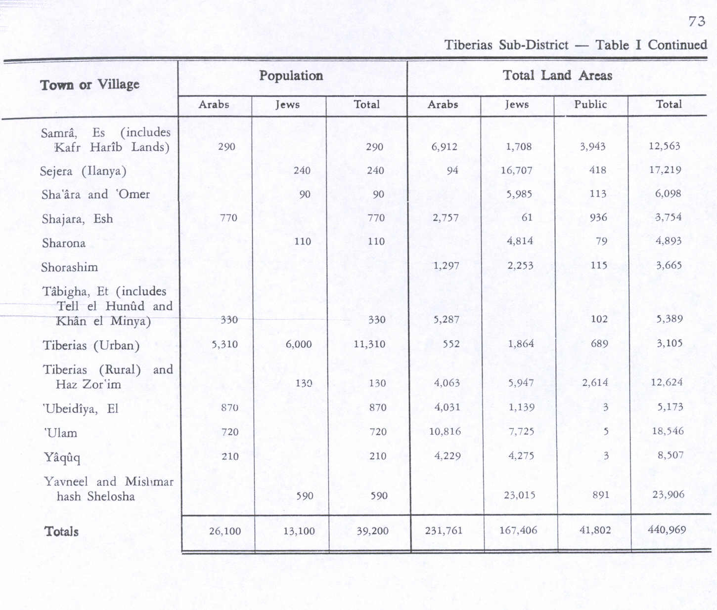
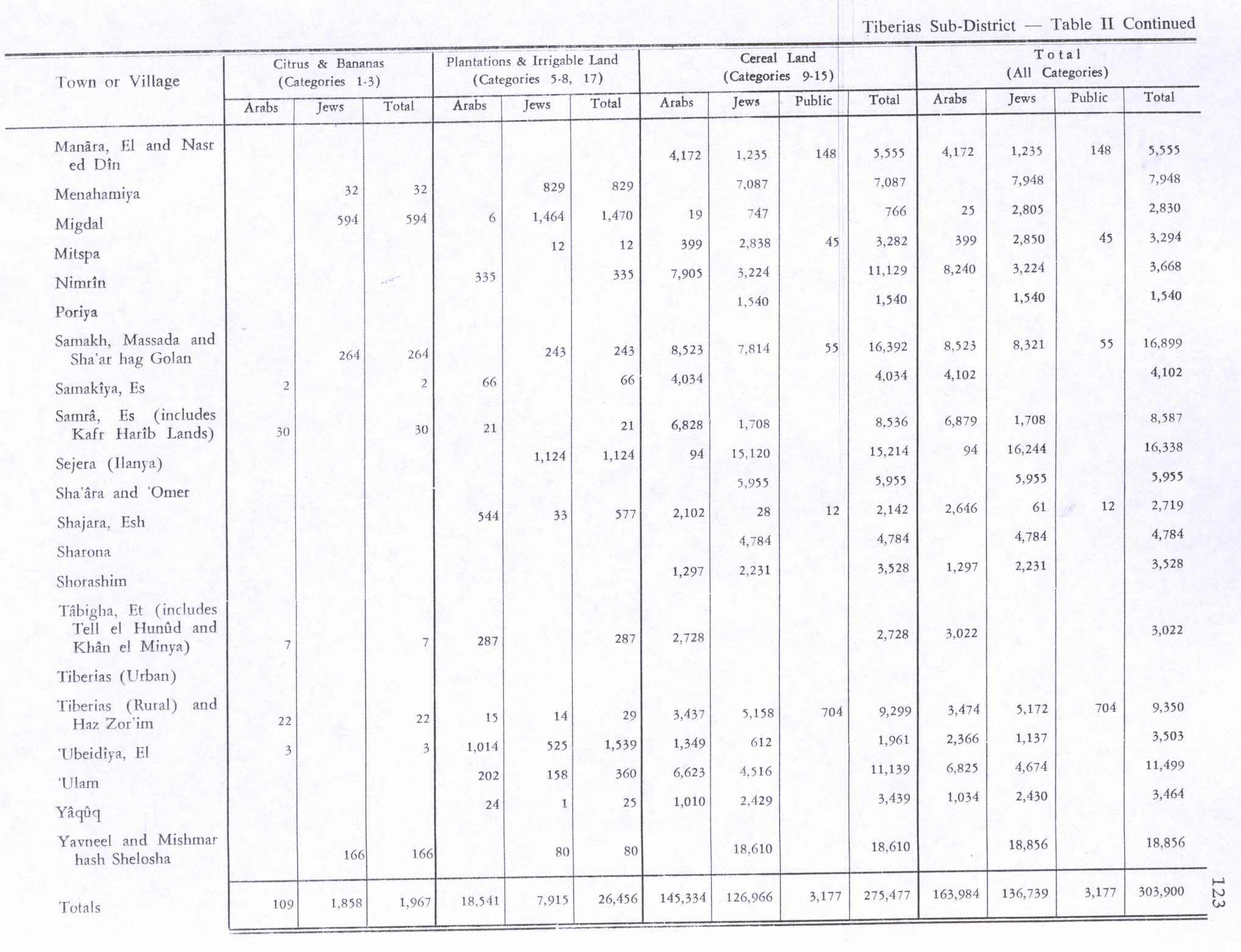
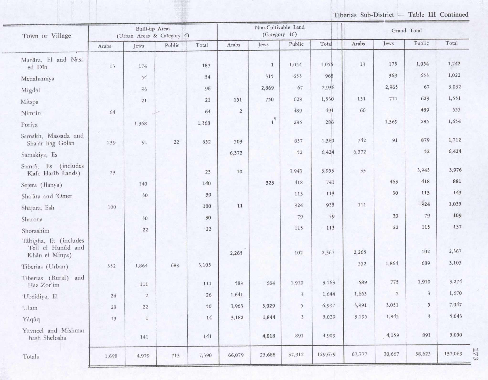
In the 1945 statistics, Es Samra had a population of 290; 280 Muslims and 10 classified as others,[1] with 6,912 dunams of Arab-owned land.[2] Of this, 30 dunams were used for citrus and bananas, 21 for plantations and irrigable land, 6,828 dunams for cereals,[14] while 23 dunams were classified as built-up area.[15]
1948, aftermath

The village became depopulated on April 21, 1948.[3][16][17][18]
HaOn was established on village land, north of the village site, in 1949.[4]
In 1992, Walid Khalidi described the village site: "Nothing remains of the village houses. A tourist resort, which consists of a few cabins and small houses, has been established on part of the village site. Other parts of the site are covered with trees. The surrounding land is cultivated by Israelis."[4]
References
Page Template:Reflist/styles.css has no content.
- ^ a b Department of Statistics, 1945, p. 12
- ^ a b Government of Palestine, Department of Statistics. Village Statistics, April, 1945. Quoted in Hadawi, 1970, p. 73
- ^ a b Morris, 2004, p. xvii, village #102. Also gives cause of depopulation
- ^ a b c d e Khalidi, 1992, p. 540
- ^ Morris, 2004, p. xxii, settlement #143
- ^ Burckhardt, 1822, pp. 278-279, cited in Khalidi, 1992, p. 539
- ^ Robinson and Smith, 1841, vol. 3, p. 264, cited in Khalidi, 1992, pp. 539-540
- ^ Robinson and Smith, 1841, vol. 3, Appendix 2, p. 131, calling it el-Khirbet es-Saudah
- ^ Guérin, 1880, p. 310-312
- ^ Schumacher, 1888, p. 186
- ^ Letter from Kibbutz Ha’On: Fallen Flyers Hadassah Magazine, 17 March 2014
- ^ Barron, 1923, Table IX, Sub-district of Tiberias, p. 39
- ^ Mills, 1932, p. 84
- ^ Government of Palestine, Department of Statistics. Village Statistics, April, 1945. Quoted in Hadawi, 1970, p. 123
- ^ Government of Palestine, Department of Statistics. Village Statistics, April, 1945. Quoted in Hadawi, 1970, p. 173
- ^ Morris, 2004, p. 186 note #179, p. 275
- ^ Morris, 2004, p. 372, note #180, p. 405
- ^ Morris, 2004, p. 513, notes #56, 57, p. 539
Sources
Page Template:Refbegin/styles.css has no content.
- Page Module:Citation/CS1/styles.css has no content.Barron, J. B., ed. (1923). Palestine: Report and General Abstracts of the Census of 1922. Government of Palestine.
- Page Module:Citation/CS1/styles.css has no content.Burckhardt, J.L. (1822). Travels in Syria and the Holy Land. London: J. Murray.
- Page Module:Citation/CS1/styles.css has no content.Department of Statistics (1945). Village Statistics, April, 1945. Government of Palestine.
- Page Module:Citation/CS1/styles.css has no content.Guérin, V. (1880). Description Géographique Historique et Archéologique de la Palestine (in français). Vol. 3: Galilee, pt. 1. Paris: L'Imprimerie Nationale.
- Page Module:Citation/CS1/styles.css has no content.Hadawi, S. (1970). Village Statistics of 1945: A Classification of Land and Area ownership in Palestine. Palestine Liberation Organization Research Center. Archived from the original on 2018-12-08. Retrieved 2009-08-18.
- Page Module:Citation/CS1/styles.css has no content.Khalidi, W. (1992). All That Remains: The Palestinian Villages Occupied and Depopulated by Israel in 1948. Washington D.C.: Institute for Palestine Studies. ISBN 0-88728-224-5.
- Page Module:Citation/CS1/styles.css has no content.Mills, E., ed. (1932). Census of Palestine 1931. Population of Villages, Towns and Administrative Areas. Jerusalem: Government of Palestine.
- Page Module:Citation/CS1/styles.css has no content.Morris, B. (2004). The Birth of the Palestinian Refugee Problem Revisited. Cambridge University Press. ISBN 978-0-521-00967-6.
- Page Module:Citation/CS1/styles.css has no content.Robinson, E.; Smith, E. (1841). Biblical Researches in Palestine, Mount Sinai and Arabia Petraea: A Journal of Travels in the year 1838. Vol. 3. Boston: Crocker & Brewster.
- Page Module:Citation/CS1/styles.css has no content.Schumacher, G. (1888). "Population list of the Liwa of Akka". Quarterly Statement - Palestine Exploration Fund. 20: 169–191.
External links
Lua error in package.lua at line 80: module 'Module:Navbox/configuration' not found.