Anzah
Script error: No such module "For".
Script error: No such module "Settlement short description".Page Module:Infobox/styles.css has no content.Page Template:Infobox settlement/styles.css has no content.
Anzah, 'Anza | |
|---|---|
| Arabic transcription(s) | |
| • Arabic | عنزه ، عنزا |
| • Latin | A'nza (official) |
| Lua error in package.lua at line 80: module 'Module:InfoboxImage/data' not found. | |
| Script error: No such module "Infobox mapframe". | |
| Lua error in Module:Location_map at line 526: Unable to find the specified location map definition: "Module:Location map/data/Palestine" does not exist. | |
| Coordinates: Lua error in package.lua at line 80: module 'Module:ISO 3166/data/PS' not found. | |
| Palestine grid | 170/196 |
| State | State of Palestine |
| Governorate | Jenin |
| Government | |
| • Type | Village council |
| Area | |
• Total | Script error: No such module "ConvertIB". |
| Population (2017) | Template:Fix comma category |
| Population (2017) | |
• Total | Template:Fix comma category |
| • Density | Script error: No such module "ConvertIB". |
| Template:Pluralize from text | Template:Pluralize from text |
| Template:Pluralize from text | Template:Pluralize from text |
| Name meaning | The goats or hill [1][2] |
Script error: No such module "Check for conflicting parameters".
Anzah or 'Anza (Template:Langx) is a Palestinian village in the located 18 km southwest of the city of Jenin in the northern West Bank. Its total land area consists of 4,740 dunams of which nearly a 1/4 is covered with olive orchards. According to the Palestinian Central Bureau of Statistics, the town had a population of 1,938 inhabitants in 2017.[3]
History
Pottery sherds from the Byzantine, early Muslim and the Medieval eras have been found here.[4]
Ottoman era
In 1830, during the Ottoman era, when the forces of Bashir Shihab II besieged Sanur, they were harassed by the people of Anzah.[5] In 1838, 'Anaza was noted as being in the District of esh-Sha'rawiyeh esh-Shurkiyeh, the eastern part.[6]
In 1870, Victor Guérin found it "situated on a hill and counting scarcely a hundred inhabitants today. A belt of olive trees surrounds it."[7]
In 1882, the PEF's Survey of Western Palestine described it as: "A village of ancient appearance on a hill perched above the plain, the houses descending the slope on the south-east. It has two wells down the hill and a good olive grove near the road on the south. The houses are of stone."[8]
British Mandate era
In the 1922 census of Palestine, conducted by the British Mandate authorities, the village had a population of 537 Muslims,[9] increasing slightly in the 1931 census to 642 Muslims, with 137 houses.[10]
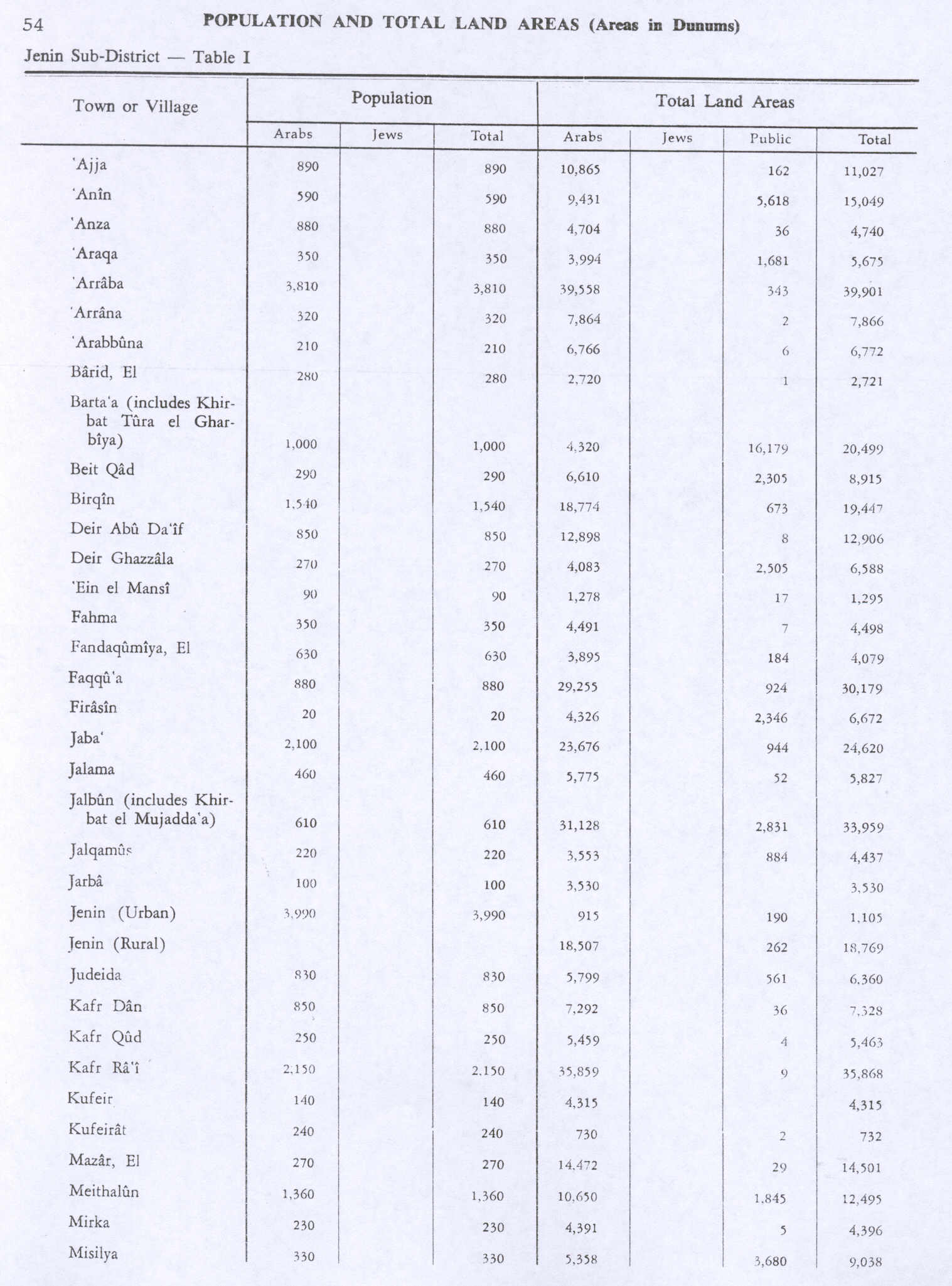
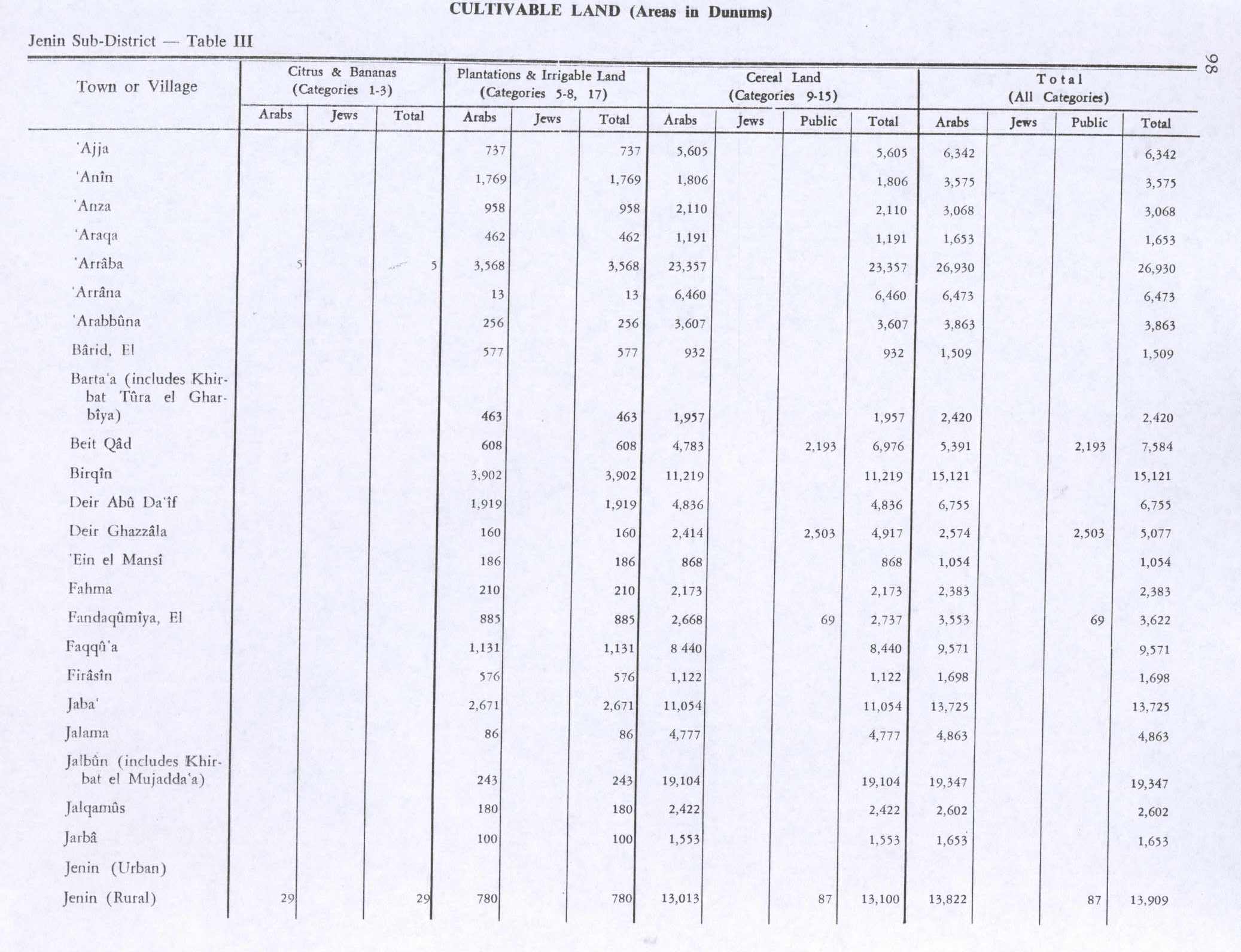
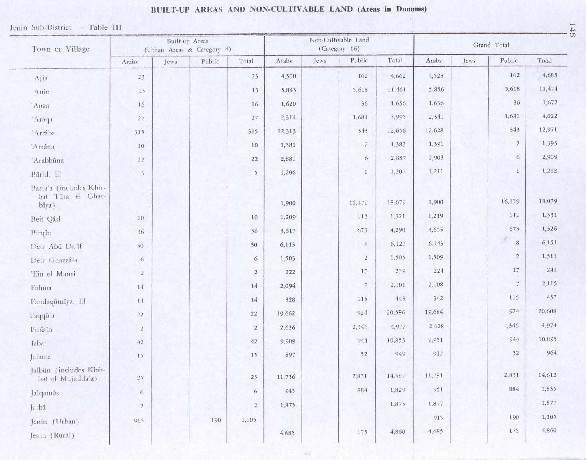
In the 1944/5 statistics, the population was 880 Muslims,[11] with a total of 4,740 dunams of land, according to an official land and population survey.[12] Of this, 958 dunams were used for plantations and irrigable land, 2,110 dunams for cereals,[13] while 16 dunams were built-up (urban) land.[14]
Jordanian era
In the wake of the 1948 Arab–Israeli War, and after the 1949 Armistice Agreements, Anzah came under Jordanian rule.
In 1961, the population of 'Anze was 1,011.[15]
Post-1967
Since the Six-Day War in 1967, Anzah has been held under Israeli occupation. According to the Israeli census of that year, the population of Anza stood at 807, of whom 13 were registered as having come from Israel.[16] Under the Oslo Accords, most of this town was assigned to Area B, with political control assigned to the Palestinian National Authority.[17]
Demography
The village has six major families: Obaid, Sadaqa, Barahmeh, Ataya, Khader, and Omour.
Anzah's residents has origins in Yatta. They say they have longstanding roots in the area.[18]
See also
Footnotes
Page Template:Reflist/styles.css has no content.
- ^ Palmer, 1881, p. 178
- ^ Zertal, 2004, p. 203
- ^ Page Module:Citation/CS1/styles.css has no content.Palestinian Central Bureau of Statistics (February 2018). "Preliminary Results of the Population, Housing and Establishments Census 2017" (PDF). p. 66. Retrieved May 19, 2023.
- ^ Zertal, 2004, pp. 202-203
- ^ Shehabi 1969, III, pp. 805-806; cited in Zertal, 2004, pp. 202-203
- ^ Robinson and Smith, 1841, vol 3, 2nd app, p. 129
- ^ Guérin, 1875, p. 217
- ^ Conder and Kitchener, 1882, SWP II, p. 155
- ^ Barron, 1923, Table IX, Sub-district of Jenin, p. 29
- ^ Mills, 1932, p. 67
- ^ Government of Palestine, Department of Statistics, 1945, p. 16 Script error: No such module "webarchive".
- ^ Government of Palestine, Department of Statistics. Village Statistics, April, 1945. Quoted in Hadawi, 1970, p. 54 Script error: No such module "webarchive".
- ^ Government of Palestine, Department of Statistics. Village Statistics, April, 1945. Quoted in Hadawi, 1970, p. 98 Script error: No such module "webarchive".
- ^ Government of Palestine, Department of Statistics. Village Statistics, April, 1945. Quoted in Hadawi, 1970, p. 148 Script error: No such module "webarchive".
- ^ Government of Jordan, Department of Statistics, 1964, p. 25
- ^ Page Module:Citation/CS1/styles.css has no content.Perlmann, Joel (November 2011 – February 2012). "The 1967 Census of the West Bank and Gaza Strip: A Digitized Version" (PDF). Levy Economics Institute. Retrieved 29 January 2018.
- ^ B'Tselem Interactive Map https://www.btselem.org/map
- ^ Grossman, D. (1986). "Oscillations in the Rural Settlement of Samaria and Judaea in the Ottoman Period". in Shomron studies. Dar, S., Safrai, S., (eds). Tel Aviv: Hakibbutz Hameuchad Publishing House. p. 350-351
Bibliography
Page Template:Refbegin/styles.css has no content.
- Page Module:Citation/CS1/styles.css has no content.Barron, J.B., ed. (1923). Palestine: Report and General Abstracts of the Census of 1922. Government of Palestine.
- Page Module:Citation/CS1/styles.css has no content.Conder, C.R.; Kitchener, H.H. (1882). The Survey of Western Palestine: Memoirs of the Topography, Orography, Hydrography, and Archaeology. Vol. 2. London: Committee of the Palestine Exploration Fund.
- Page Module:Citation/CS1/styles.css has no content.Government of Jordan, Department of Statistics (1964). First Census of Population and Housing. Volume I: Final Tables; General Characteristics of the Population (PDF).
- Page Module:Citation/CS1/styles.css has no content.Government of Palestine, Department of Statistics (1945). Village Statistics, April, 1945.
- Page Module:Citation/CS1/styles.css has no content.Guérin, V. (1875). Description Géographique Historique et Archéologique de la Palestine (in français). Vol. 2: Samarie, pt. 2. Paris: L'Imprimerie Nationale.
- Page Module:Citation/CS1/styles.css has no content.Hadawi, S. (1970). Village Statistics of 1945: A Classification of Land and Area ownership in Palestine. Palestine Liberation Organization Research Center. Archived from the original on 2018-12-08. Retrieved 2014-09-10.
- Page Module:Citation/CS1/styles.css has no content.Mills, E., ed. (1932). Census of Palestine 1931. Population of Villages, Towns and Administrative Areas. Jerusalem: Government of Palestine.
- Page Module:Citation/CS1/styles.css has no content.Palmer, E.H. (1881). The Survey of Western Palestine: Arabic and English Name Lists Collected During the Survey by Lieutenants Conder and Kitchener, R. E. Transliterated and Explained by E.H. Palmer. Committee of the Palestine Exploration Fund.
- Page Module:Citation/CS1/styles.css has no content.Robinson, E.; Smith, Eli (1841). Biblical Researches in Palestine, Mount Sinai and Arabia Petraea: A Journal of Travels in the year 1838. Vol. 3. Boston: Crocker & Brewster.
- Page Module:Citation/CS1/styles.css has no content.Shehabi, Kheidar (1969). Lubnanfi Ahd el-Amraa el-Shehabiih (in العربية). Vol. III. Beyrouth.
{{cite book}}: CS1 maint: location missing publisher (link) - Page Module:Citation/CS1/styles.css has no content.Zertal, A. (2004). The Manasseh Hill Country Survey. Vol. 1. Boston: BRILL. ISBN 9004137564.
External links
- Welcome To 'Anza
- Anza, Welcome to Palestine
- Survey of Western Palestine, Map 11: IAA, Wikimedia commons
Lua error in package.lua at line 80: module 'Module:Navbox/configuration' not found. Lua error in package.lua at line 80: module 'Module:Authority control/config' not found.