Beit Ijza
Script error: No such module "Settlement short description".Page Module:Infobox/styles.css has no content.Page Template:Infobox settlement/styles.css has no content.
Beit Ijza | |
|---|---|
| Arabic transcription(s) | |
| • Arabic | Script error: No such module "Lang". |
| • Latin | Bayt Ijza (official) |
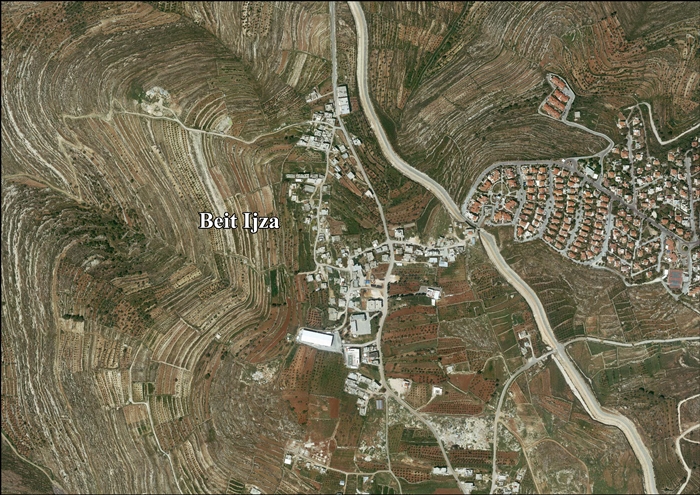
| Lua error in package.lua at line 80: module 'Module:InfoboxImage/data' not found. View of Beit Ijza, 2012 | |
| Script error: No such module "Infobox mapframe". | |
| Lua error in Module:Location_map at line 526: Unable to find the specified location map definition: "Module:Location map/data/Palestine" does not exist. | |
| Coordinates: Lua error in package.lua at line 80: module 'Module:ISO 3166/data/PS' not found. | |
| Palestine grid | 164/139 |
| State | State of Palestine |
| Governorate | Quds |
| Government | |
| • Type | Local Development Committee |
| Elevation | Script error: No such module "ConvertIB". |
| Population (2017)[2] | Template:Fix comma category |
| Population (2017)[2] | |
• Total | Template:Fix comma category |
| • Density | Script error: No such module "ConvertIB". |
| Template:Pluralize from text | Template:Pluralize from text |
| Postcode | P115 [3] |
| Template:Pluralize from text | Template:Pluralize from text |
| Name meaning | Beit Izza, the house of Izza, from personal name [4] |
Script error: No such module "Check for conflicting parameters".
Beit Ijza (Template:Langx, also spelled Bayt Ijza); is a village in the Jerusalem Governorate in the central West Bank with an area of 2,526 dunams. Located approximately six miles north of Jerusalem, it had a population of 698 in 2007 and 854 by 2017.[2][5]
Location
Beit Ijza is located 11 kilometers (6.8 mi) north-west of Jerusalem, bordered by Al Jib to the east and Al Jib lands to the north, Beit Duqqu to the west, and Biddu to the south.[1]
History
Ottoman era
Beit Izja has its earliest mention in a record from 1538/9, where it was listed as a mazra'a (farm).[6] In 1596 it appeared in the tax registers as being in the nahiya of Al-Quds in the liwa of Al-Quds under the name of Bayt Iza. It had a population of 6 household;[7] who were all Muslims. They paid a fixed Ziamet tax-rate of 33.3% on agricultural products, including wheat, barley, summer crops, olive trees, vineyards, fruit trees, goats and beehives, in addition to occasional revenues; a total of 2,500 akçe.[7]
In 1738 Richard Pococke named it Beteser, seeing it "on the hill to the east of the valley".[8][original research?]
In 1838, it was described as a Muslim village, located in the Beni Malik area, west of Jerusalem.[9]
In 1883 the PEF's Survey of Western Palestine (SWP) described Beit Izza as: "a village of moderate size on a hill with a spring at some distance to the west."[10]
British Mandate era
In the 1922 census of Palestine conducted by the British Mandate authorities, "Bait Izza" had a population of 59 Muslims,[11] decreasing slightly in the 1931 census to 54 Muslims, in 14 houses.[12]
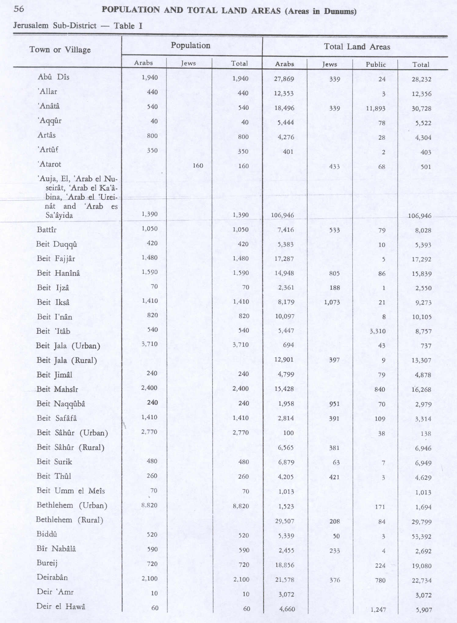
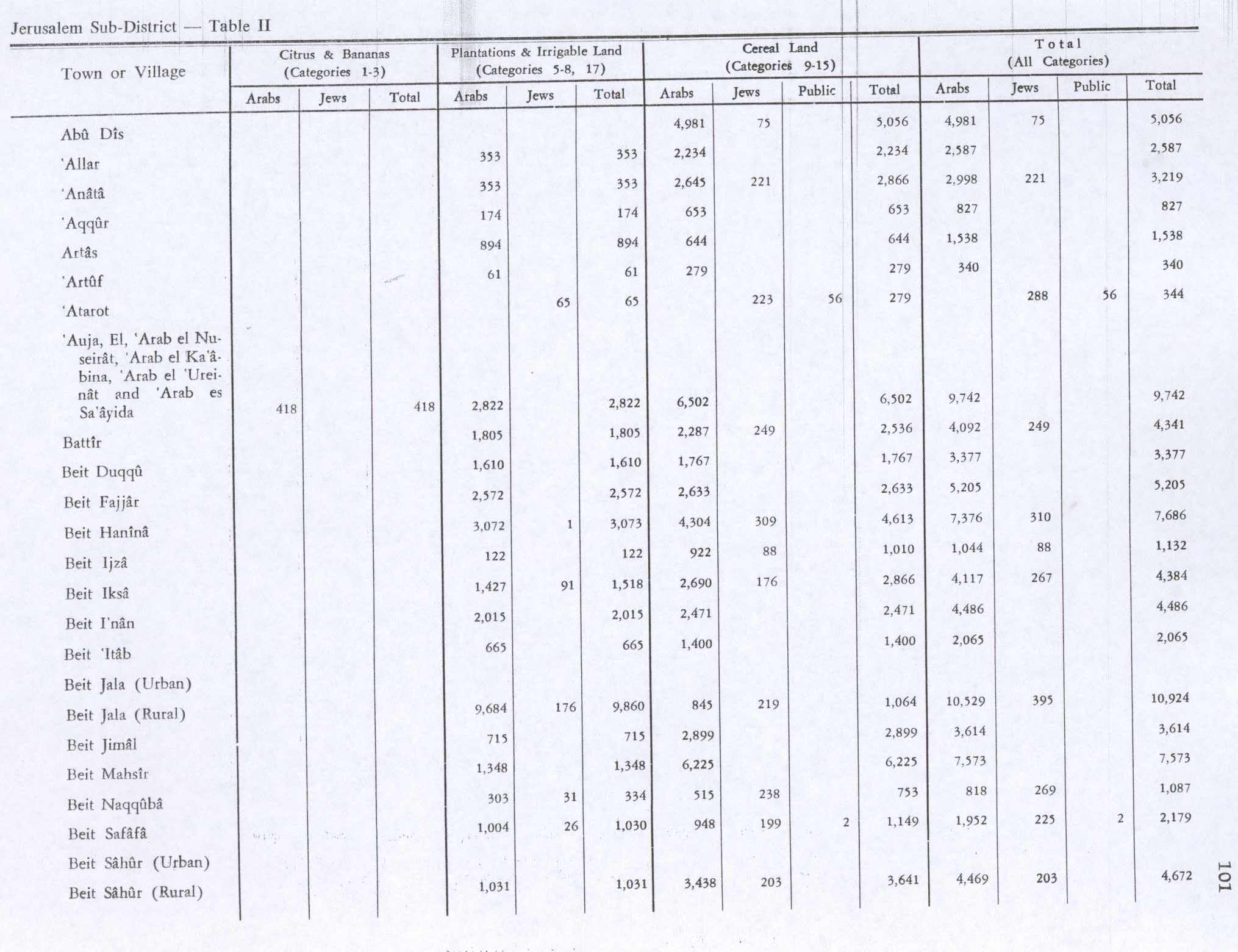
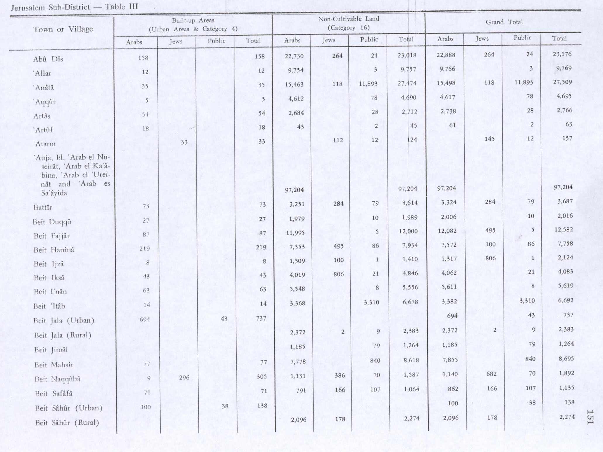
In the 1945 statistics Beit Ijza had a population of 70 Muslims,[13] with a total of 2,550 dunams of land, according to an official land and population survey.[14] Of this, Arabs used 122 dunams for plantations and irrigable land, 922 for cereals,[15] while 8 dunams were built-up (urban) land.[16]
Jordanian era
In the wake of the 1948 Arab–Israeli War, and after the 1949 Armistice Agreements, Beit Ijza came under Jordanian rule.
The Jordanian census of 1961 found 129 inhabitants in Beit Ijza.[17]
Post 1967
Since the Six-Day War in 1967, Beit Ijza has been under Israeli occupation.
Under the 1995 Oslo II Accord, 6.7% of the total village area was classified as Area B, and the remaining 93.3% classified as Area C, under full Israeli control. Israel has confiscated land in Beit Ijza for settlements, including Giv'at Ze'ev and Giv'on Ha'hadasha. In addition, the separation wall extends onto Beit Ijza land, leaving 980 dunums, (or 38.1% of the total village's area), behind the wall, on the Israeli side. The Palestinian owners of the land must rely on Israeli permission to access their land. Permission is only granted to the property owner, often elderly people, leaving them unable to hire help to work the land.[18] One family in Beit Ijza lives with walls on all sides of its property due to extensive land expropriations by Israel.[19]
Shrine
Tawfiq Canaan found a Maqam (shrine) for en-nabi Yusif, on a spot which dominated Beit Ijza.[20]
References
Page Template:Reflist/styles.css has no content.
- ^ a b Beit Ijza village profile, ARIJ, 2012, p. 4
- ^ a b Page Module:Citation/CS1/styles.css has no content.Preliminary Results of the Population, Housing and Establishments Census, 2017 (PDF). Palestinian Central Bureau of Statistics (PCBS) (Report). State of Palestine. February 2018. pp. 64–82. Retrieved 2023-10-24.
- ^ Page Module:Citation/CS1/styles.css has no content."وزارة الاتصالات-PostalCodes". Palestine Ministry of Telecom & Information Technology. Archived from the original on 2021-03-06. Retrieved 2022-01-27.
- ^ Palmer, 1881, p. 286
- ^ Population, Housing and Establishment Census 2007. Palestinian Central Bureau of Statistics (PCBS). 2008. Retrieved on 2012-02-27.
- ^ Grossman, D. (1986). "Oscillations in the Rural Settlement of Samaria and Judaea in the Ottoman Period". in Shomron studies. Dar, S., Safrai, S., (eds). Tel Aviv: Hakibbutz Hameuchad Publishing House. p. 361
- ^ a b Hütteroth and Abdulfattah, 1977, p. 119
- ^ Pococke, 1745, vol 2, p. 49 NB "east" is probable typo for "west"
- ^ Robinson and Smith, 1841, vol 3, Appendix 2, p. 124
- ^ Conder and Kitchener, 1883, SWP III, p. 16
- ^ Barron, 1923, Table VII, Sub-district of Jerusalem, p. 15
- ^ Mills, 1932, p. 38
- ^ Government of Palestine, Department of Statistics, 1945, p. 24
- ^ Government of Palestine, Department of Statistics. Village Statistics, April, 1945. Quoted in Hadawi, 1970, p. 56
- ^ Government of Palestine, Department of Statistics. Village Statistics, April, 1945. Quoted in Hadawi, 1970, p. 101
- ^ Government of Palestine, Department of Statistics. Village Statistics, April, 1945. Quoted in Hadawi, 1970, p. 151
- ^ Government of Jordan, Department of Statistics, 1964, p. 23
- ^ Beit Ijza village profile, 2012, ARIJ, pp. 16-17
- ^ Page Module:Citation/CS1/styles.css has no content.Hass, Amira (2019-11-05). "A Wall, Arrests and Close Surveillance: How Israel Fences in a Palestinian Family". Haaretz. Retrieved 2020-02-22.
- ^ Canaan, 1927, pp. 4, 17, 294, 295
Bibliography
Page Template:Refbegin/styles.css has no content.
- Page Module:Citation/CS1/styles.css has no content.Barron, J.B., ed. (1923). Palestine: Report and General Abstracts of the Census of 1922. Government of Palestine.
- Page Module:Citation/CS1/styles.css has no content.Canaan, T. (1927). Mohammedan Saints and Sanctuaries in Palestine. London: Luzac & Co.
- Page Module:Citation/CS1/styles.css has no content.Conder, C.R.; Kitchener, H.H. (1883). The Survey of Western Palestine: Memoirs of the Topography, Orography, Hydrography, and Archaeology. Vol. 3. London: Committee of the Palestine Exploration Fund.
- Page Module:Citation/CS1/styles.css has no content.Government of Jordan, Department of Statistics (1964). First Census of Population and Housing. Volume I: Final Tables; General Characteristics of the Population (PDF).
- Page Module:Citation/CS1/styles.css has no content.Government of Palestine, Department of Statistics (1945). Village Statistics, April, 1945.
- Page Module:Citation/CS1/styles.css has no content.Hadawi, S. (1970). Village Statistics of 1945: A Classification of Land and Area ownership in Palestine. Palestine Liberation Organization Research Center.
- Page Module:Citation/CS1/styles.css has no content.Hütteroth, W.-D.; Abdulfattah, K. (1977). Historical Geography of Palestine, Transjordan and Southern Syria in the Late 16th Century. Erlanger Geographische Arbeiten, Sonderband 5. Erlangen, Germany: Vorstand der Fränkischen Geographischen Gesellschaft. ISBN 3-920405-41-2.
- Page Module:Citation/CS1/styles.css has no content.Mills, E., ed. (1932). Census of Palestine 1931. Population of Villages, Towns and Administrative Areas. Jerusalem: Government of Palestine.
- Page Module:Citation/CS1/styles.css has no content.Palmer, E.H. (1881). The Survey of Western Palestine: Arabic and English Name Lists Collected During the Survey by Lieutenants Conder and Kitchener, R. E. Transliterated and Explained by E.H. Palmer. Committee of the Palestine Exploration Fund.
- Page Module:Citation/CS1/styles.css has no content.Pococke, R. (1745). A description of the East, and some other countries. Vol. 2. London: Printed for the author, by W. Bowyer.
- Page Module:Citation/CS1/styles.css has no content.Pringle, D. (1997). Secular buildings in the Crusader Kingdom of Jerusalem: an archaeological Gazetteer. Cambridge University Press. ISBN 0521-46010-7. (pp. 17 - 18: this shows Beit Ijza, according to Pringle, 2009, p. 234)
- Page Module:Citation/CS1/styles.css has no content.Pringle, D. (2009). The Churches of the Crusader Kingdom of Jerusalem: Volume IV The cities of Acre and Tyre with Addenda and Corrigenda to Volumes I-III. Cambridge University Press. ISBN 978-0-521-85148-0. (p. 234)
- Page Module:Citation/CS1/styles.css has no content.Robinson, E.; Smith, E. (1841). Biblical Researches in Palestine, Mount Sinai and Arabia Petraea: A Journal of Travels in the year 1838. Vol. 3. Boston: Crocker & Brewster.
External links
- Welcome to Bayt Ijza
- Survey of Western Palestine, Map 17: IAA, Wikimedia commons
- Bayt Ijza village (fact sheet), Applied Research Institute–Jerusalem (ARIJ)
- Beit Ijza village profile, ARIJ
- Beit Ijza aerial photo, ARIJ
- Locality Development Priorities and Needs in Beit Ijza, ARIJ
- POICA
Template:Jerusalem Governorate Lua error in package.lua at line 80: module 'Module:Authority control/config' not found.