Beitin
Script error: No such module "about".
Script error: No such module "Settlement short description".Page Module:Infobox/styles.css has no content.Page Template:Infobox settlement/styles.css has no content.
Beitin | |
|---|---|
| Arabic transcription(s) | |
| • Arabic | بيتين |
| • Latin | Baytin (official) Bittin (unofficial) |
| Lua error in package.lua at line 80: module 'Module:InfoboxImage/data' not found. Beitin, late 19th century, by Felix Bonfils | |
| Script error: No such module "Infobox mapframe". | |
| Lua error in Module:Location_map at line 526: Unable to find the specified location map definition: "Module:Location map/data/Palestine" does not exist. | |
| Coordinates: Lua error in package.lua at line 80: module 'Module:ISO 3166/data/PS' not found. | |
| Palestine grid | 172/148 |
| State | State of Palestine |
| Governorate | Ramallah and al-Bireh |
| Founded | Early 19th century[citation needed] |
| Government | |
| • Type | Village council (from 1996) |
| • Head of Municipality | DIAB YASIN |
| Area | |
• Total | Script error: No such module "ConvertIB". |
| Population (2017)[1] | Template:Fix comma category |
| Population (2017)[1] | |
• Total | Template:Fix comma category |
| • Density | Script error: No such module "ConvertIB". |
| 5k | |
| Template:Pluralize from text | Template:Pluralize from text |
| Template:Pluralize from text | Template:Pluralize from text |
| house of faith | corruption of the Hebrew "Bethel",[2] house ("beth" or "beit") of God ("el")[3] |
Script error: No such module "Check for conflicting parameters".
Beitin (Template:Langx) is a Palestinian village in the Ramallah and al-Bireh Governorate in the central West Bank, located 5 kilometers (3.1 mi) northeast of Ramallah along the Ramallah-Nablus road. The Palestinian village of Dura al-Qar' and Ein Yabrud lie to the north, Rammun to the east, Deir Dibwan to the southeast and al-Bireh to the southwest. The Israeli settlement of Beit El is northwest of Beitin.
Beitin was established in the mid-19th century by settlers from the nearby Burqa.[4] It stands on the site of the ancient town and biblical sanctuary of Bethel,[4][5][6] which was left abandoned after the Crusader period. The area remained uninhabited until the late Ottoman period, when modern Beitin was founded.[4]
Geography
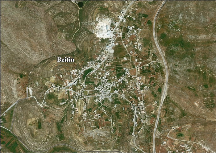
There are several springs around Beitin, which is known for its olive, almond, fig and plum groves.[7]
History
Early history and archaeology
Script error: No such module "Labelled list hatnote". Beitin is identified with the ancient settlement of Bethel, and preserves its ancient name.[6][5][4] The site was first settled during the Chalcolithic period. Sherds from the Early, Intermediate, Middle and Late Bronze Age, as well as the Iron Age I and II, the Persian, Hellenistic, Roman,[8] the Byzantine[8][9] and Crusader/Ayyubid periods have been found.[8] At the ruins of the Crusader watchtower (al-Burj), residential remains from the Mamluk period were discovered.[10]
In the Hellenistic and Roman periods, Bethel was mentioned in 1 Maccabees, Josephus' writings, and in several patristic texts.[5] The town was garrisoned by Bacchides (during the Maccabean revolt) and later by Vespasian (during the First Jewish–Roman War).[5] In Byzantine times, Bethel held annual festivals on October 18. The population was Eastern Orthodox Christian and monks from the Sinai Peninsula, particularly Zosimas of Palestine, were known to have visited the town.[11] A church dating from the fifth century CE was found at the site.[5]
Bethel was abandoned after the 1187 defeat of the Crusaders at the hands of Saladin and the ensuing destruction of Christian sites. It remained obscure and unmentioned by various sources from the 13th to the 19th century, including Yaqut, Mujir al-Din, and European travelers, likely indicating a state of ruin since the fall of the Crusader kingdom.[4]
Ottoman period
Beitin was absent from Ottoman censuses of the 16th century. When visited by Robinson in 1838 and Schwartz before 1845, it still lay in ruins. However, by Guérin's visit in 1863, it had become inhabited, with its residents originating from the nearby Burqa.[4]
After Beitin was reestablished, the village came under the administration of the Mutasarrif ("Governorate") of Jerusalem.[12] In the early 19th century, people from Transjordan and other places migrated to Beitin[11][13] and built a mosque near the site of the old church.[14]
In 1838 Edward Robinson noted Beitin as a place "in ruins or deserted," located immediately north of Jerusalem.[6][15]
In 1863 Victor Guérin found the village to have 400 inhabitants,[16] while an Ottoman village list from around 1870 showed that Beitin had an adult male population of 140, in a total of 55 houses (thus excluding women and children).[17][18]
In 1882 the PEF's Survey of Western Palestine described Beitin as a village "built on the side of a flat spur which rises slightly on the north. On the south-east is a flat dell, with good fig and pomegranate gardens, and there are other fig-trees round the village and among the houses. The cottages have a ruinous appearance, with rough stone walls. There is one square white house in two stories, which is visible from a great distance. The ground is very open, and the slopes gentle; the village slopes down gradually south-east. The surrounding ground is quite bare of trees, of white chalk, very barren and stony on the south; of hard limestone cropping up on the north; the fields divided off by low drystone walls. The contrast of the grey rocks, the red ploughland and the dark green figs is very striking. The remains of a good-sized tower exist towards the north, and on the south the walls of a church of Crusading date, once dedicated to St. Joseph. The population is stated at 400. The place is supplied from a fine spring on the south, which wells up in a circular basin. The spring is double, and was surrounded with a large reservoir, 314 feet long north-west and south-east, by 217 feet; of massive stones. The eastern and southern walls are standing about 10 feet high. The spring is perennial..."[19]
In 1896 the population of Betin was estimated to be about 360 persons.[20]
In 1907, small gardens and a few old tombs were found in the vicinity, and the Muslim population was known for its strength and fearlessness.[21]
British Mandate period
In the 1922 census of Palestine conducted by the British Mandate authorities, Baitin had a population of 446; all Muslims,[22] increasing at the time of the 1931 census to 566, still all Muslim, in 135 houses.[23]
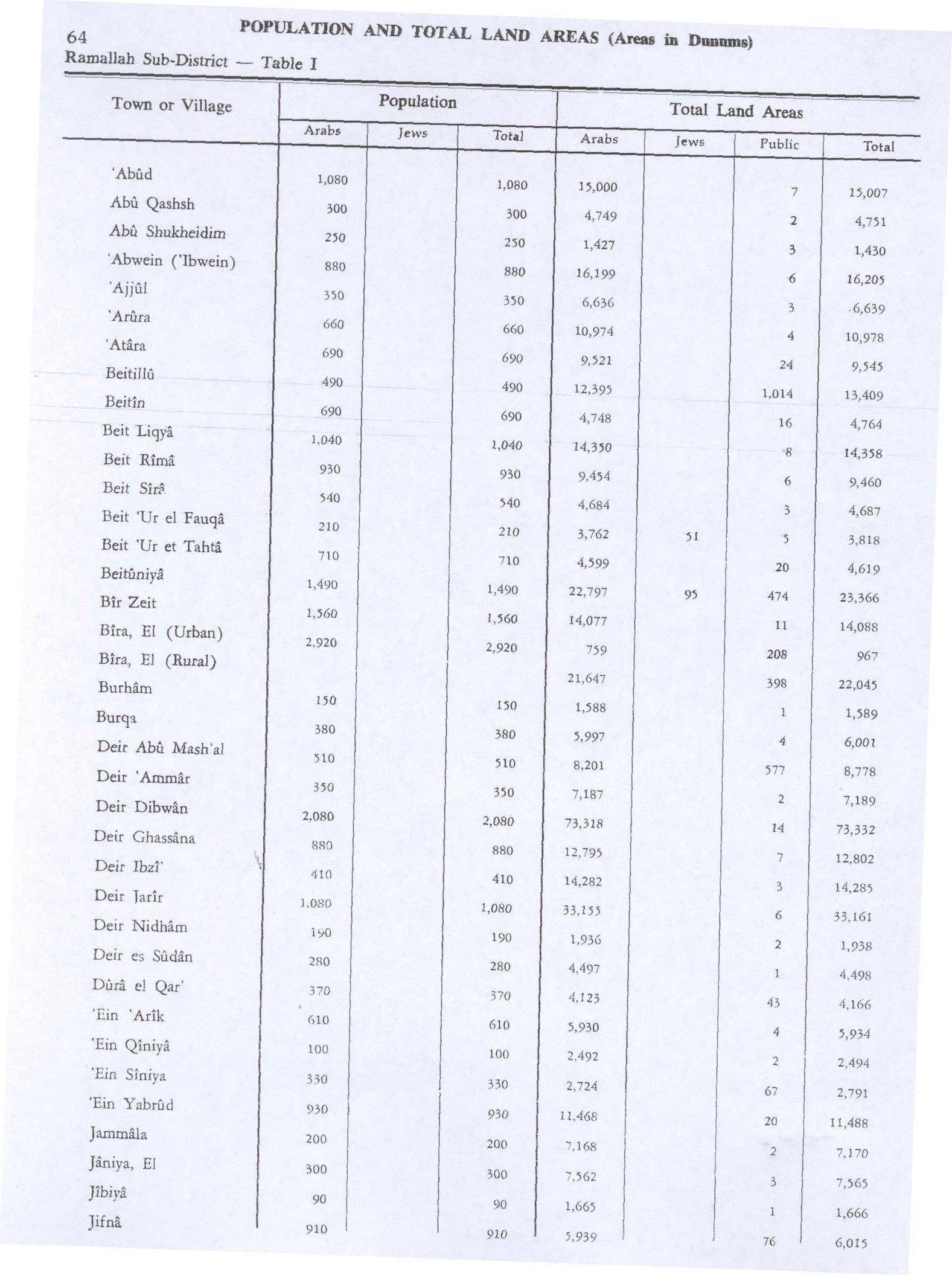
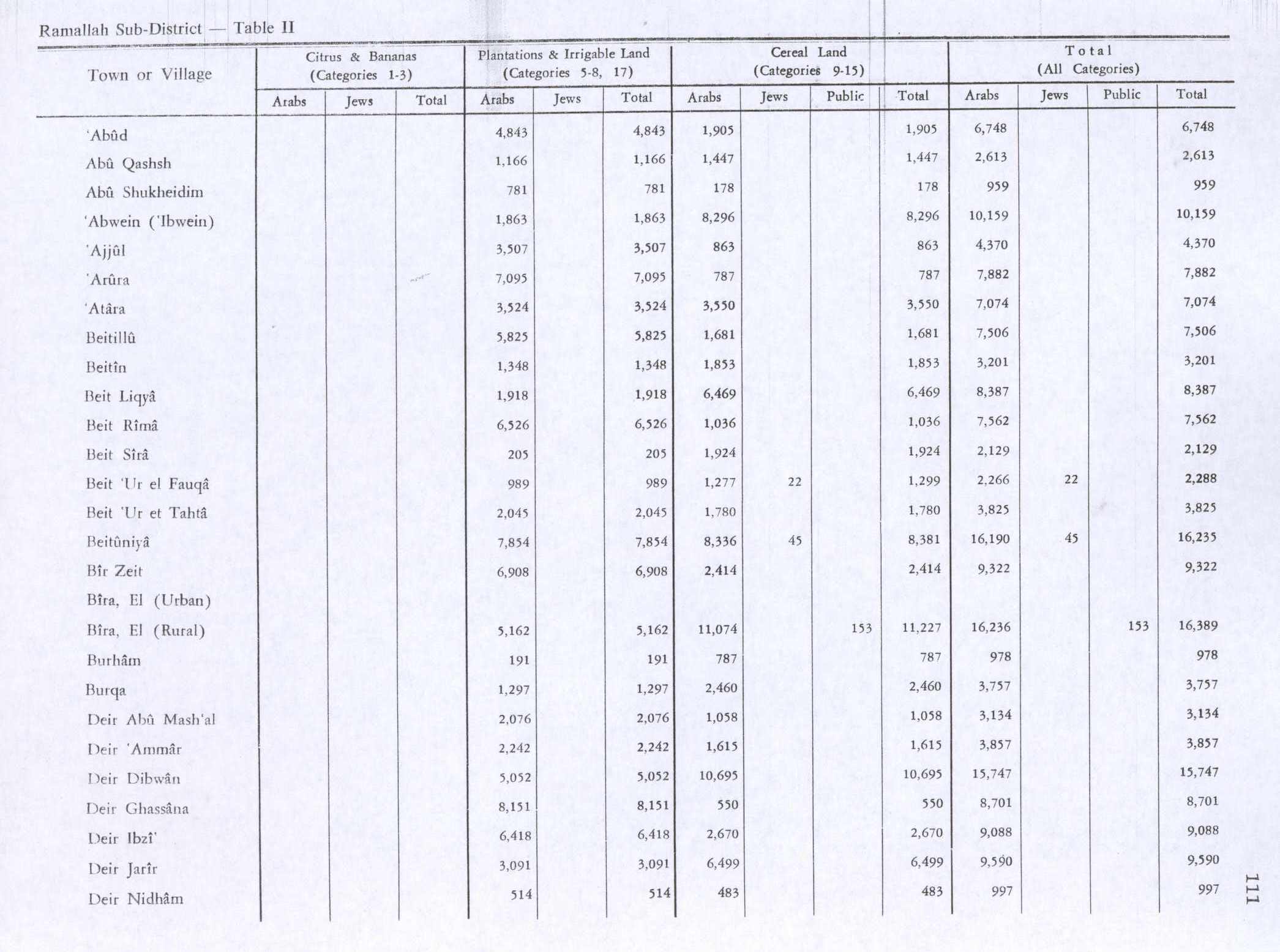
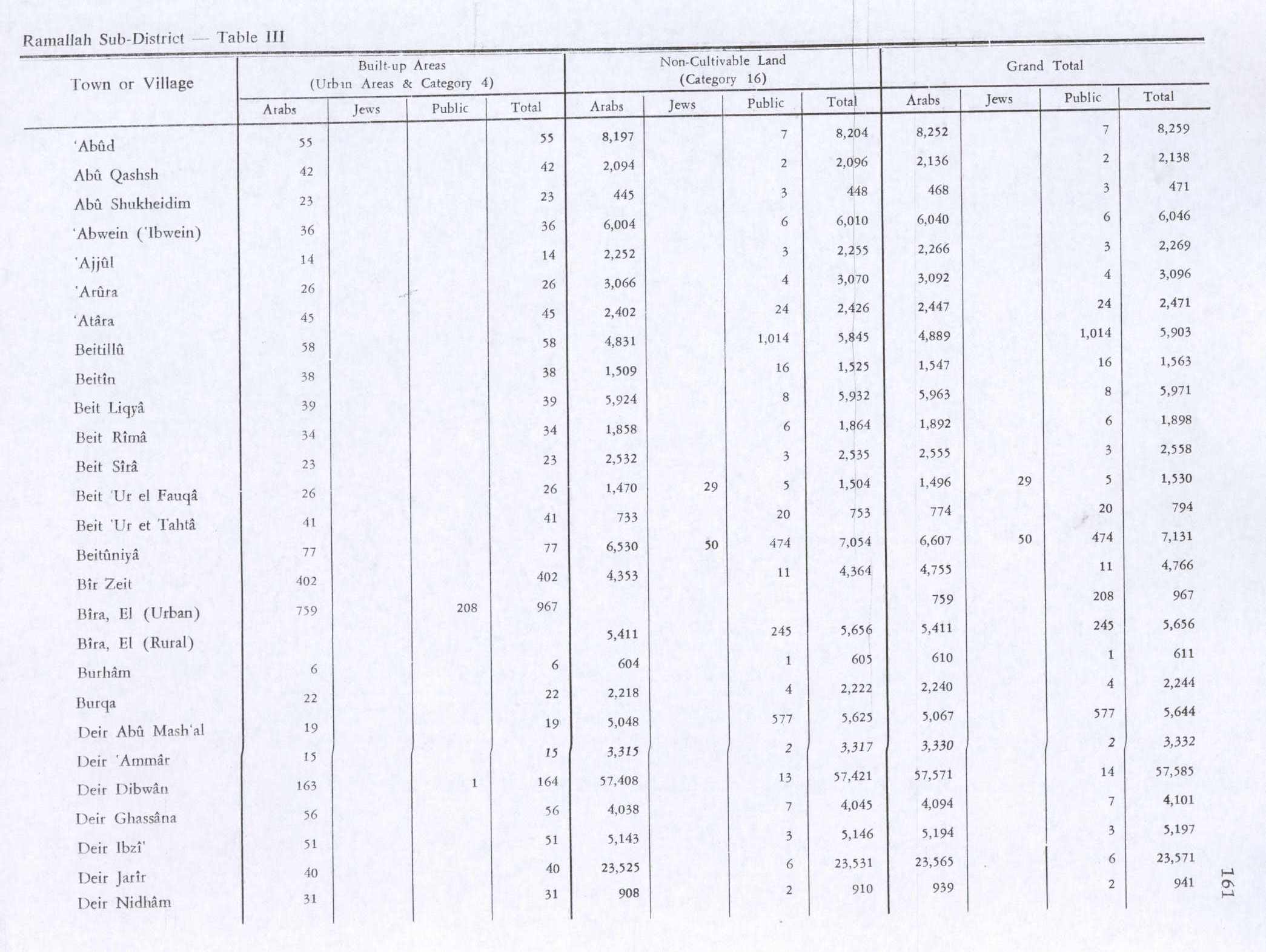
In the 1945 statistics the population was 690 Muslims,[24] while the total land area was 4,764 dunams, according to an official land and population survey.[25] Of this, 1,348 were allocated for plantations and irrigable land, 1,853 for cereals,[26] while 38 dunams were classified as built-up areas.[27]
Jordanian period
In the wake of the 1948 Arab–Israeli War, and after the 1949 Armistice Agreements, Beitin came under Jordanian rule.
In 1961, a Jordanian census found the population to be 1,017.[28]
Post-1967
After the Six-Day War in 1967, Beitin has, with the rest of the West Bank, been held under Israeli occupation. The population in the 1967 census conducted by the Israeli authorities was 958, of whom 134 originated from the Israeli territory.[29]
After the 1995 accords, 19,1% of the village land is classified as Area B, while the remaining 80.9% is defined as Area C land (full Israeli control). Beitin village land has also been taken in order to construct the illegal Israeli outpost Givat Asaf.[30][31]
On 19 December 2011, Israeli settlers were accused of carrying out a second price tag attack in only four days, in which five Palestinian-owned cars were burnt and the walls of several houses were sprayed with graffiti.[32] During the first incident (15 December 2011), the assailants not only vandalized a mosque, but also attacked an IDF military base in the West Bank, injuring a top Israeli commander.[33] According to witnesses of the second incident, the Israeli army dispersed the settlers without arresting any of them,[32] presumably also those who attacked the Israeli commander, although four days earlier the incident had prompted Israeli Prime-Minister, Benjamin Netanyahu, to say: "We won't let them attack our soldiers. We won't let them ignite a religious war with our neighbors. We won't let them desecrate mosques. We won't let them harm Jews or Arabs."[33]
Landmarks
Church ruins
The ruins of the Byzantine church are known in Arabic as "al-Muqater" or "Khirbet al-Kenise" ("Ruins of the Church").[11][34] According to Röhricht, when the Crusaders arrived, they found a ruined church. They built another and placed it first under the Abbey of St. Joseph of Arimathea, later under the Canons of the Holy Sepulcher.[11][35] The ruins of the church were drawn in the 1880s.[36][37]
Tower ruins ("al-Burj")
Another ruin, called "al-Burj Beitin" ("the Tower of Beitin") or simply al-Burj is located in the western part of the village.[11] They were also drawn in the 1880s.[38] The ruins of the Burj are about 1 meter tall, and apparently built on the older ruins of a Byzantine monastery.[39] Some have believed that it was constructed on the site where Abraham built an altar.[14][40] According to biblical scholar Edward Robinson who visited Palestine in the 19th century, al-Burj Beitin consisted of dilapidated stones that used to form part of a fortress and a Greek church.[6] Al-Burj was used as a watch tower by the Crusaders.[11]
Demographics
In 1997, Palestinian refugees accounted for exactly 30% of the population, which was 1,510 at the time.[41]
According to the Palestinian Central Bureau of Statistics (PCBS), Beitin had a population of over 3,050 inhabitants in 2006.[42] In 2007, a PCBS census recorded a population of 2,143 (1,128 men and 1,015 women). There were 717 homes in the village and the average household size consisted of 4.9 family members.[43]
References
Page Template:Reflist/styles.css has no content.
- ^ Page Module:Citation/CS1/styles.css has no content."Main Indicators by Type of Locality - Population, Housing and Establishments Census 2017" (PDF). Palestinian Central Bureau of Statistics (PCBS). Archived from the original (PDF) on 2023-10-14. Retrieved 2021-01-19.
- ^ Palmer, 1881, p. 226
- ^ Robinson and Smith, 1841, vol 2, pp. 128 -129
- ^ a b c d e f Page Module:Citation/CS1/styles.css has no content.Elitzur, Yoel (2004). Ancient Place Names in the Holy Land: Preservation and History. Jerusalem; Winona Lake, Virginia: The Hebrew University Magness Press; Eisenbrauns. pp. 59–60.
- ^ a b c d e Page Module:Citation/CS1/styles.css has no content.Avi-Yonah, Michael (1976). "Gazetteer of Roman Palestine". Qedem. 5: 38. ISSN 0333-5844.
- ^ a b c d Robinson and Smith, 1841, vol. 2, pp. 125-130.
- ^ Page Module:Citation/CS1/styles.css has no content."Palestinian Cultural Sites: Beitin-Ramallah". Jerusalem Media and Communications Center (JMCC). Archived from the original on 2007-03-10. Retrieved 2011-12-19.
- ^ a b c Finkelstein and Lederman, 1997, p. 518
- ^ Dauphin, 1998, p. 835
- ^ Keio University, Archaeological Excavations and Development of Resources for Tourism at Beitin (Bethel) Script error: No such module "webarchive"., website of the Japan Consortium for International Cooperation in Cultural Heritage Independent Administrative Instituti. Accessed 15 April 2019.
- ^ a b c d e f Luza, also Bethel - (Beitin) Script error: No such module "webarchive". Studium Biblicum Franciscanum - Jerusalem. 2000-12-19.
- ^ Page Module:Citation/CS1/styles.css has no content."Palestinian Places: Beitin". Jerusalem Media and Communications Center (JMCC). Retrieved 2011-12-19.
- ^ Lutfiyya, 1966, p. 36
- ^ a b Visit Palestine: Bittin Script error: No such module "webarchive". Visit Palestine.
- ^ Robinson and Smith, 1841, vol 3, Appendix 2, p. 122
- ^ Guérin, 1869, pp. 14-26
- ^ Socin, 1879, p. 148. It was noted in the Bire District
- ^ Hartmann, 1883, p. 127 also noted 55 houses
- ^ Conder and Kitchener, 1882, SWP II, pp. 295-296
- ^ Schick, 1896, p. 121
- ^ Grant, 1907, p. 218
- ^ Barron, 1923, Table VII, Sub-district of Ramallah, p. 16
- ^ Mills, 1932, p. 47
- ^ Government of Palestine, Department of Statistics, 1945, p. 26
- ^ Government of Palestine, Department of Statistics. Village Statistics, April, 1945. Quoted in Hadawi, 1970, p. 64
- ^ Government of Palestine, Department of Statistics. Village Statistics, April, 1945. Quoted in Hadawi, 1970, p. 111
- ^ Government of Palestine, Department of Statistics. Village Statistics, April, 1945. Quoted in Hadawi, 1970, p. 161
- ^ Government of Jordan, Department of Statistics, 1964, p. 24 It was further noted (note 2) that it was governed by a mukhtar.
- ^ Page Module:Citation/CS1/styles.css has no content.Perlmann, Joel (November 2011 – February 2012). "The 1967 Census of the West Bank and Gaza Strip: A Digitized Version" (PDF). Levy Economics Institute. Retrieved 23 January 2018.
- ^ Beitin (village profile), ARIJ, pp. 17-19
- ^ Nahum Barnea, 'Beitunian nights: The IDF in the West Bank', Ynet 18 March 2016.
- ^ a b Page Module:Citation/CS1/styles.css has no content."Settlers burn 5 cars in Ramallah village". Ma'an News Agency. 2011-12-19. Retrieved 2011-12-19.
- ^ a b Page Module:Citation/CS1/styles.css has no content.Teibel, Amy (15 December 2011). "Jewish radicals get off hook in Israel". NewsOK.com. Retrieved 17 February 2017.
- ^ Conder and Kitchener, 1882, SWP II, p. 305
- ^ Röhricht, 1887, ZDPV 10, pp. 207, 292
- ^ Wilson, c1881, vol 1, pp. 219 (ill.), 221
- ^ Pringle, 1993, pp. 104 -105
- ^ Wilson, c1881, vol 1, p. 217 (ill.)
- ^ Finkelstein and Lederman, 1997, p. 522
- ^ Conder and Kitchener, 1882, SWP II, p. 307
- ^ Palestinian Population by Locality and Refugee Status Script error: No such module "webarchive". Palestinian Central Bureau of Statistics.
- ^ Projected Mid -Year Population for Ramallah & Al Bireh Governorate by Locality 2004- 2006 Palestinian Central Bureau of Statistics (PCBS)
- ^ 2007 PCBS Census. Palestinian Central Bureau of Statistics. p.114.
Bibliography
Page Template:Refbegin/styles.css has no content.
- Page Module:Citation/CS1/styles.css has no content.Barron, J.B., ed. (1923). Palestine: Report and General Abstracts of the Census of 1922. Government of Palestine.
- Page Module:Citation/CS1/styles.css has no content.Clermont-Ganneau, C.S. (1896). [ARP] Archaeological Researches in Palestine 1873-1874, translated from the French by J. McFarlane. Vol. 2. London: Palestine Exploration Fund. (p. 284)
- Page Module:Citation/CS1/styles.css has no content.Conder, C.R.; Kitchener, H.H. (1882). The Survey of Western Palestine: Memoirs of the Topography, Orography, Hydrography, and Archaeology. Vol. 2. London: Committee of the Palestine Exploration Fund.
- Page Module:Citation/CS1/styles.css has no content.Conder, C.R.; Kitchener, H.H. (1883). The Survey of Western Palestine: Memoirs of the Topography, Orography, Hydrography, and Archaeology. Vol. 3. London: Committee of the Palestine Exploration Fund.
- Page Module:Citation/CS1/styles.css has no content.Dauphin, C. (1998). La Palestine byzantine, Peuplement et Populations. BAR International Series 726 (in français). Vol. III : Catalogue. Oxford: Archeopress. ISBN 0-860549-05-4.
- Page Module:Citation/CS1/styles.css has no content.Easton, M.G. (1893). Illustrated Bible dictionary. Harper & brothers.
- Page Module:Citation/CS1/styles.css has no content.Finkelstein, I.; Lederman, Zvi, eds. (1997). Highlands of many cultures. Tel Aviv: Institute of Archaeology of Tel Aviv University Publications Section. ISBN 965-440-007-3.
- Page Module:Citation/CS1/styles.css has no content.Government of Jordan, Department of Statistics (1964). First Census of Population and Housing. Volume I: Final Tables; General Characteristics of the Population (PDF).
- Page Module:Citation/CS1/styles.css has no content.Government of Palestine, Department of Statistics (1945). Village Statistics, April, 1945.
- Page Module:Citation/CS1/styles.css has no content.Guérin, V. (1869). Description Géographique Historique et Archéologique de la Palestine (in français). Vol. 1: Judee, pt. 3. Paris: L'Imprimerie Nationale.
- Page Module:Citation/CS1/styles.css has no content.Guérin, V. (1874). Description Géographique Historique et Archéologique de la Palestine (in français). Vol. 2: Samarie, pt. 1. Paris: L'Imprimerie Nationale. (pp. 205-206)
- Page Module:Citation/CS1/styles.css has no content.Grant, E. (1907). The Peasantry of Palestine. Boston, New York [etc.]: The Pilgrim Press.
- Page Module:Citation/CS1/styles.css has no content.Hadawi, S. (1970). Village Statistics of 1945: A Classification of Land and Area ownership in Palestine. Palestine Liberation Organization Research Center.
- Page Module:Citation/CS1/styles.css has no content.Hartmann, M. (1883). "Die Ortschaftenliste des Liwa Jerusalem in dem türkischen Staatskalender für Syrien auf das Jahr 1288 der Flucht (1871)". Zeitschrift des Deutschen Palästina-Vereins. 6: 102–149.
- Page Module:Citation/CS1/styles.css has no content.Lutfiyya, Abdulla M. (1966). Baytin : A Jordanian Village : A Study Of Social Institutions And Social Change In A Folk Community. Walter de Gruyter. ISBN 3111396150.
- Page Module:Citation/CS1/styles.css has no content.Mills, E., ed. (1932). Census of Palestine 1931. Population of Villages, Towns and Administrative Areas. Jerusalem: Government of Palestine.
- Page Module:Citation/CS1/styles.css has no content.Palmer, E.H. (1881). The Survey of Western Palestine: Arabic and English Name Lists Collected During the Survey by Lieutenants Conder and Kitchener, R. E. Transliterated and Explained by E.H. Palmer. Committee of the Palestine Exploration Fund.
- Page Module:Citation/CS1/styles.css has no content.Pringle, D. (1993). The Churches of the Crusader Kingdom of Jerusalem: Volume I A-K (excluding Acre and Jerusalem). Cambridge University Press. ISBN 0-521-39036-2.
- Page Module:Citation/CS1/styles.css has no content.Robinson, E.; Smith, E. (1841). Biblical Researches in Palestine, Mount Sinai and Arabia Petraea: A Journal of Travels in the year 1838. Vol. 2. Boston: Crocker & Brewster.
- Page Module:Citation/CS1/styles.css has no content.Robinson, E.; Smith, E. (1841). Biblical Researches in Palestine, Mount Sinai and Arabia Petraea: A Journal of Travels in the year 1838. Vol. 3. Boston: Crocker & Brewster.
- Page Module:Citation/CS1/styles.css has no content.Röhricht, R. (1887). "Studien zur mittelalterlichen Geographie und Topographie Syriens". Zeitschrift des Deutschen Palästina-Vereins. 10: 195–344.
- Page Module:Citation/CS1/styles.css has no content.Schick, C. (1896). "Zur Einwohnerzahl des Bezirks Jerusalem". Zeitschrift des Deutschen Palästina-Vereins. 19: 120–127.
- Page Module:Citation/CS1/styles.css has no content.Socin, A. (1879). "Alphabetisches Verzeichniss von Ortschaften des Paschalik Jerusalem". Zeitschrift des Deutschen Palästina-Vereins. 2: 135–163.
- Page Module:Citation/CS1/styles.css has no content.Tristram, H.B. (1865). Land of Israel, A Journal of travel in Palestine, undertaken with special reference to its physical character. London: Society for Promoting Christian Knowledge.
- Page Module:Citation/CS1/styles.css has no content.Wilson, C.W., ed. (c. 1881). Picturesque Palestine, Sinai and Egypt. Vol. 1. New York: D. Appleton.
External links
- Welcome To Beitin
- Survey of Western Palestine, Map 14: IAA, Wikimedia commons
- Beitin (fact sheet), Applied Research Institute–Jerusalem (ARIJ)
- Beitin (village profile), ARIJ
- Beitin (aerial photo), ARIJ
Lua error in package.lua at line 80: module 'Module:Navbox/configuration' not found.