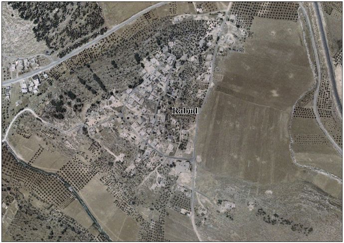
Rabud
Script error: No such module "Settlement short description".Page Module:Infobox/styles.css has no content.Page Template:Infobox settlement/styles.css has no content.
Rabud | |
|---|---|
| Arabic transcription(s) | |
| • Arabic | Script error: No such module "Lang". |
| • Latin | Khirbet Rabud (official) |
| Lua error in package.lua at line 80: module 'Module:InfoboxImage/data' not found. Rabud | |
| Script error: No such module "Infobox mapframe". | |
| Lua error in Module:Location_map at line 526: Unable to find the specified location map definition: "Module:Location map/data/Palestine" does not exist. | |
| Coordinates: Lua error in package.lua at line 80: module 'Module:ISO 3166/data/PS' not found. | |
| Palestine grid | 151/093 |
| State | State of Palestine |
| Governorate | Hebron |
| Government | |
| • Type | Village council (from 1993) |
| • Head of Municipality | Muhammad Huraibat[1] |
| Area | |
• Total | Script error: No such module "ConvertIB". |
| Population (2017)[2] | Template:Fix comma category |
| Population (2017)[2] | |
• Total | Template:Fix comma category |
| • Density | Script error: No such module "ConvertIB". |
| Template:Pluralize from text | Template:Pluralize from text |
| Template:Pluralize from text | Template:Pluralize from text |
Script error: No such module "Check for conflicting parameters".
Rabud (Template:Langx, also known as Khirbet Rabud) is a Palestinian village in the southern West Bank, in the Hebron Governorate of the State of Palestine. The village was the site of an ancient Canaanite and Judahite city. The village had a population of 2,816 in 2017.[2]
Etymology
According to Palmer, the name Khirbet Rabud means "the ruin of the animal's lair".[3]
Demographics
Part of the Hebron Governorate of Palestine, it is located 13 kilometers southwest of Hebron and about 5 km northwest of as-Samu. Rabud had a population of 2,262 in the 2007 census by the Palestinian Central Bureau of Statistics (PCBS).[4] According to research by the Applied Research Institute-Jerusalem, Rabud's history dates back to the Canaanite period in Palestine, but the modern inhabitants of the village migrated from the Arabian Peninsula.[5] The principal families are the Huraibat, Quteinah, al-Uqela and Shanan.[5]
History
Antiquity
Rabud is thought to lie on the site of the ancient Judean Kohanic city of Kiryat Sefer or Debir (Script error: No such module "Bibleverse".).[6][7] The archaeologist William G. Dever estimates its population at around 1,500 during the 9th and 8th centuries BCE.[7] One of the stratigraphic levels at the site (B-II) shows evidence of destruction, likely from Sennacherib's campaign in Judah in the late 8th century, and at least one LMLK jar handle has been found there.[7] By the 7th century BCE, the site of Khirbet Rabud had grown to a relatively large town that featured both a fortified city and an unwalled settlement. Both were razed when the First Temple was destroyed (587-6 BCE). It saw limited settlement during the Persian period.[8]
Late Antiquity
Ceramics from the Byzantine era have been found here.[9]
Ottoman period
In 1863, Victor Guérin found here "caves and cisterns dug into the rock, ...small demolished houses and, on the highest point, the remains of a roughly built tower". North and south-east of this place were two pierced walls, with many caves. Guérin named them Heurkan Beni Hasan.[10][11]
In 1883, the PEF's Survey of Western Palestine found here "walls, cisterns, and rude cave tombs."[11]
British Mandate period
The 1931 census of Palestine wrote that "the village in the Hebron sub-district commonly known as Dura is a congeries of neighbouring localities each of which has a distinctive name; and, while Dura is a remarkable example of neighbourly agglutination, the phenomenon is not infrequent in other villages". The total of 70 locations, among them Kh. Rabud, listed in the report had 1538 occupied houses and a population of 7255 Muslims.[12]
Jordanian period
In the wake of the 1948 Arab–Israeli War, and after the 1949 Armistice Agreements, Rabud came under Jordanian rule.
In 1961, the population of Rabud was 206.[13]
Post-1967
After the Six-Day War in 1967, Rabud has been under Israeli occupation.
A village council was established by the Palestinian National Authority in 1993 to administer Rabud's civil affairs and provide limited municipal services.[5] There is currently one mosque, Salah ad-Din Mosque, which serves the village.
References
Page Template:Reflist/styles.css has no content.
- ^ Rabud Profile. Jerusalem Media and Communications Center (JMCC).
- ^ a b Page Module:Citation/CS1/styles.css has no content.Preliminary Results of the Population, Housing and Establishments Census, 2017 (PDF). Palestinian Central Bureau of Statistics (PCBS) (Report). State of Palestine. February 2018. pp. 64–82. Retrieved 2023-10-24.
- ^ Palmer, 1881, p 401
- ^ 2007 PCBS Census. Palestinian Central Bureau of Statistics (PCBS).
- ^ a b c Rabud Village Profile. Applied Research Institute-Jerusalem (ARIJ). 2009.
- ^ Trevor Bryce (2009). The Routledge Handbook of the Peoples and Places of Ancient Western Asia: From the Early Bronze Age to the Fall of the Persian Empire. Taylor & Francis. p. 588. ISBN 978-0-415-39485-7
- ^ a b c Page Module:Citation/CS1/styles.css has no content.Dever, William G. (2017). Beyond the Texts: an archaeological portrait of ancient Israel and Judah. Atlanta: SBL Press. pp. 393, 431, 560. ISBN 978-0-88414-218-8.
- ^ Page Module:Citation/CS1/styles.css has no content.Faust, Avraham (2012). Judah in the Neo-Babylonian Period: The Archaeology of Desolation. Society of Biblical Literature. p. 26. doi:10.2307/j.ctt5vjz28. ISBN 978-1-58983-725-6. JSTOR j.ctt5vjz28.
- ^ Dauphin, 1998, p. 967
- ^ Guérin, 1869, p. 370
- ^ a b Conder and Kitchener, 1883, SWP III, p. 360
- ^ Mills, 1932, pp. Preface, 28–32
- ^ Government of Jordan, Department of Statistics, 1964, p. 22
Bibliography
Page Template:Refbegin/styles.css has no content.
- Page Module:Citation/CS1/styles.css has no content.Conder, C.R.; Kitchener, H.H. (1883). The Survey of Western Palestine: Memoirs of the Topography, Orography, Hydrography, and Archaeology. Vol. 3. London: Committee of the Palestine Exploration Fund.
- Page Module:Citation/CS1/styles.css has no content.Dauphin, C. (1998). La Palestine byzantine, Peuplement et Populations. BAR International Series 726 (in French). Vol. III : Catalogue. Oxford: Archeopress. ISBN 0-860549-05-4.
{{cite book}}: CS1 maint: unrecognized language (link) - Page Module:Citation/CS1/styles.css has no content.Government of Jordan, Department of Statistics (1964). First Census of Population and Housing. Volume I: Final Tables; General Characteristics of the Population (PDF).
- Page Module:Citation/CS1/styles.css has no content.Guérin, V. (1869). Description Géographique Historique et Archéologique de la Palestine (in French). Vol. 1: Judee, pt. 3. Paris: L'Imprimerie Nationale.
{{cite book}}: CS1 maint: unrecognized language (link) - Page Module:Citation/CS1/styles.css has no content.Mills, E., ed. (1932). Census of Palestine 1931. Population of Villages, Towns and Administrative Areas. Jerusalem: Government of Palestine.
- Page Module:Citation/CS1/styles.css has no content.Palmer, E.H. (1881). The Survey of Western Palestine: Arabic and English Name Lists Collected During the Survey by Lieutenants Conder and Kitchener, R. E. Transliterated and Explained by E.H. Palmer. Committee of the Palestine Exploration Fund.
External links
Page Module:Side box/styles.css has no content.Page Template:Sister project/styles.css has no content.
- Welcome to Khirbat Rabud
- Rabud, Welcome to Palestine
- Survey of Western Palestine, Map 21: IAA, Wikimedia commons
- Rabud village (fact sheet), Applied Research Institute–Jerusalem (ARIJ)
- Rabud village profile, ARIJ
- Rabud aerial photo, ARIJ
- The priorities and needs for development in Rabud village based on the community and local authorities’ assessment, ARIJ
- Rabud, google-map
Lua error in package.lua at line 80: module 'Module:Navbox/configuration' not found. Lua error in package.lua at line 80: module 'Module:Authority control/config' not found.