Thingbu
Script error: No such module "Settlement short description".Page Module:Infobox/styles.css has no content.Page Template:Infobox settlement/styles.css has no content.
Thingbu | |
|---|---|
Village | |
| Script error: No such module "Infobox mapframe". | |
| Lua error in Module:Location_map at line 526: Unable to find the specified location map definition: "Module:Location map/data/India Arunachal Pradesh" does not exist. | |
| Coordinates: Lua error: callParserFunction: function "#coordinates" was not found. | |
| Country | File:Flag of India.svg India |
| State | Arunachal Pradesh |
| District | Tawang district |
| Elevation | Script error: No such module "ConvertIB". |
| Population | Template:Fix comma category |
| • Density | Script error: No such module "ConvertIB". |
| Template:Pluralize from text | Template:Pluralize from text |
| Languages | |
| • Official | English |
| Time zone | UTC+05:30 (IST) |
| Template:Pluralize from text | Template:Pluralize from text |
| ISO 3166 code | IN-AR |
| Vehicle registration | AR |
Script error: No such module "Check for conflicting parameters".
Thingbu is a settlement in Tawang district in the north-eastern state of Arunachal Pradesh, India.
Location
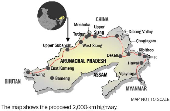
It is located on the proposed 2,000-kilometre-long (1,200 mi) Mago-Thingbu to Vijaynagar Arunachal Pradesh Frontier Highway along the McMahon Line,[1][2][3][4] alignment map of which can be seen here and here.[5]
Demographics
Thingbu is a small village occupied by the Monpa tribe and consists of 58 households.
Culture
Main festivals: Losar, Gandan Ngamchod etc.
Religion: Buddhist.
Dress: Traditional Shinka, Totung, Tenga-kime, Khichin, etc. ( for women). Khanjar, Chhuba, Totung, etc. (for men)
Climate
Heavy snowfall occurs during the months of December, January and February.
Transport
Tawang-Mago-Chuna-Tulung La Road (TMCTL Road) as part of Arunachal Frontier Highway, rises from Tawang (6,000 ft) to Thingbu HQ and Mago in the east, and Chuna and Tulung La (17,000 ft, with a memorial of India's 4 Assam Rifles soldiers killed n Ambush by China in October India October 1975) further northeast, was turned into black-topped motorable road in 2025. Earlier it was a narrow mule track.[6]
See also
Lua error in mw.title.lua at line 404: bad argument #2 to 'title.new' (unrecognized namespace name 'Portal').
Page Template:Div col/styles.css has no content.
References
Page Template:Reflist/styles.css has no content.
- ^ Page Module:Citation/CS1/styles.css has no content."Top officials to meet to expedite road building along China border". Dipak Kumar Dash. timesofindia.indiatimes.com. Retrieved 27 October 2014.
- ^ Page Module:Citation/CS1/styles.css has no content."Narendra Modi government to provide funds for restoration of damaged highways". dnaindia.com. Retrieved 27 October 2014.
- ^ Page Module:Citation/CS1/styles.css has no content."Indian Government Plans Highway Along Disputed China Border". Ankit Panda. thediplomat.com. Retrieved 27 October 2014.
- ^ Page Module:Citation/CS1/styles.css has no content."Govt planning road along McMohan line in Arunachal Pradesh: Kiren Rijiju". Live Mint. Retrieved 26 October 2014.
- ^ Page Module:Citation/CS1/styles.css has no content."China warns India against paving road in Arunachal". Ajay Banerjee. tribuneindia.com. Retrieved 26 October 2014.
- ^ [1], Times Now News, 3 Sept 2025.