Whyte Avenue
Page Module:Message box/ambox.css has no content.Page Template:Multiple issues/styles.css has no content.
This article has multiple issues. Please help improve it or discuss these issues on the talk page. (Learn how and when to remove these messages)
Template:RefimproveTemplate:More footnotesPage Module:Message box/ambox.css has no content.
|
Page Module:Infobox/styles.css has no content.
| File:Whyte (82) Av.jpg | |
|---|---|
| 82 Avenue | |
| Lua error in package.lua at line 80: module 'Module:InfoboxImage/data' not found. | |
| Script error: No such module "Infobox mapframe". | |
| Native name | Template:Native name checker |
| Namesake | Sir William Whyte |
| Maintained by | the City of Edmonton |
| Length | Script error: No such module "ConvertIB".[1] |
| Location | Edmonton |
| West end | 114 Street / University Avenue |
| Major junctions | 109 Street, 104 Street, Gateway Boulevard, 75 Street |
| East end | Sherwood Park Freeway |
| Construction | |
| Inauguration | 1890s |
Script error: No such module "Check for conflicting parameters".
Whyte (82) Avenue is an arterial road in south-central Edmonton, Alberta, Canada. It became the main street of the City of Strathcona as it formed, and now runs through Old Strathcona. It was named in 1891 after Sir William Whyte, the superintendent of the CPR's western division from 1886 to 1897, knighted by King George V in 1911.[2] Whyte (82) Avenue is part of a 40-kilometre-long (25 mi) continuous roadway that runs through Sherwood Park, Edmonton, and St. Albert that includes Wye Road, Sherwood Park Freeway, portions of University Avenue and Saskatchewan Drive, Groat Road, and St. Albert Trail.
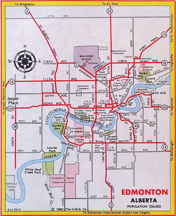
The roadway was originally the core of the city of Strathcona and was the division between the north and south quadrants, and Main Street, now 104 Street (Calgary Trail) was the division between the west and east quadrants.[3] In 1912, Edmonton and Strathcona amalgamated, and Edmonton adopted its present numbering system. Whyte Avenue was co-designated 82 Avenue, which allowed it to keep both names. As Alberta's highway system developed, Whyte Avenue became part of Highway 2 (previously Highway 1 prior to 1941) between 104 Street and 109 Street, and it was part of Highway 14 east of 104 Street.[4] The highway designations were moved to Whitemud Drive in the 1980s.
A small section of 82 Avenue exists as a collector road between 71 Street and 50 Street, where the main roadway transitions to the Sherwood Park Freeway.
Neighbourhoods
List of neighbourhoods Whyte (82) Avenue runs through, in order from west to east:
Major intersections
Starting at the west end of University Avenue. The entire route is in Edmonton.
Lua error in package.lua at line 80: module 'Module:Road data/util' not found. Lua error in package.lua at line 80: module 'Module:Road data/util' not found. Lua error in package.lua at line 80: module 'Module:Road data/util' not found. Lua error in package.lua at line 80: module 'Module:Road data/util' not found. Lua error in package.lua at line 80: module 'Module:Road data/util' not found. Lua error in package.lua at line 80: module 'Module:Road data/util' not found. Lua error in package.lua at line 80: module 'Module:Road data/util' not found. Lua error in package.lua at line 80: module 'Module:Road data/util' not found. Lua error in package.lua at line 80: module 'Module:Road data/util' not found. Lua error in package.lua at line 80: module 'Module:Road data/util' not found. Lua error in package.lua at line 80: module 'Module:Road data/util' not found. Lua error in package.lua at line 80: module 'Module:Road data/util' not found.
| km[1] | mi | Destinations | Notes | ||
|---|---|---|---|---|---|
| Page Module:Jctbtm/styles.css has no content.1.000 mi = 1.609 km; 1.000 km = 0.621 mi Page Template:Hlist/styles.css has no content.
| |||||
See also
Page Module:Side box/styles.css has no content.Page Template:Sister project/styles.css has no content.
Script error: No such module "Attached KML".
References
Page Template:Reflist/styles.css has no content.
- ^ a b Template:Google maps
- ^ Monto, Tom. Old Strathcona - Edmonton's Southside Roots (Edmonton: Crang Publishing/Alhambra Books, 2011).
- ^ Page Module:Citation/CS1/styles.css has no content.Mundy’s Map of The Twin Cities Edmonton & Strathcona (Map). The Mundy Blueprint Co. 1911.
- ^ Page Module:Citation/CS1/styles.css has no content.Alberta Official Road Map (Map). Government of the Province of Alberta. 1962. Edmonton inset. Archived from the original on March 30, 2017.
Lua error in package.lua at line 80: module 'Module:Navbox/configuration' not found. Lua error in package.lua at line 80: module 'Module:Navbox/configuration' not found.



_Av.jpg)
.JPG)