Changlang district
Script error: No such module "about". Template:DMCA Template:DMCA
Script error: No such module "Settlement short description".Page Module:Infobox/styles.css has no content.Page Template:Infobox settlement/styles.css has no content.
Changlang district | |
|---|---|
| Lua error in package.lua at line 80: module 'Module:InfoboxImage/data' not found. Peaks in Namdapha National Park | |
| Lua error in package.lua at line 80: module 'Module:InfoboxImage/data' not found. Location in Arunachal Pradesh | |
| Script error: No such module "Infobox mapframe". | |
| Coordinates (Changlang): Lua error: callParserFunction: function "#coordinates" was not found. | |
| Country | File:Flag of India.svg India |
| State | Arunachal Pradesh |
| Division | Arunachal East |
| Headquarters | Changlang |
| Area | |
• Total | Script error: No such module "ConvertIB". |
| Population (2011) | Template:Fix comma category |
| Population (2011) | |
• Total | Template:Fix comma category |
| • Density | Script error: No such module "ConvertIB". |
| Template:Pluralize from text | Template:Pluralize from text |
| Demographics | |
| • Literacy | 61.9%[1] |
| • Sex ratio | 914[1] |
| Time zone | UTC+05:30 (IST) |
| Pincode(s) | 792 120[2] |
| Template:Pluralize from text | Template:Pluralize from text |
| Website | changlang |
Script error: No such module "Check for conflicting parameters".
Changlang district (/tʃæŋˈlæŋ/) is a subdivision of the Indian state of Arunachal Pradesh, located south of Lohit district and north of Tirap district. Naga people reside here. As of 2011 it is the second most populous district of Arunachal Pradesh (out of 16) after Papum Pare.[1] It has become one of the major districts in the area owing to the presence of crude oil, coal and mineral resources in addition to tourism and hydropower.
History
The plains, foothills and lower hills of the district were part of the Chutia kingdom while the higher hills were inhabited by the Tangsas and the Tutsa people. The plains fell into Ahom rule in 1524 and a new position Thaomung Bo-klang (Hatkhowa Gohain) was created to administer the plains region and manage the salt mines, with headquarters at Mohong region. The district was created on 14 November 1987, when it was split from Tirap district.[3]
The Indian Government resettled many Chakmas and Hajong. They had fled from East Pakistan, which constructed the Kaptai Dam on their lands displacing hundreds of thousands.
Geography
Changlang district occupies an area of 4,662 square kilometres (1,800 sq mi),[4] comparatively equivalent to Indonesia's Lombok Island.[5]
It falls in a region that receives high rainfall. The region is rich in wildlife with a different kind of flora and fauna. The district has both plains and highlands. Most of the plains are in the valley of Dihing. The area is prone to occasional floods.
National protected area
Economy
Page Module:Message box/ambox.css has no content.
| [icon] | This section needs expansion. You can help by Template:Protected page maintenance message. (January 2024) |
The Dihing river is the main source of fish for the local people. The freshwater fish are very much in demand they hardly reach major towns nearby like Tinsukia, Doomdooma, Digboi and Dibrugarh.
Administrative divisions
There are 5 Arunachal Pradesh Legislative Assembly constituencies located in this district: Bordumsa, Miao, Nampong, Changlang South and Changlang North. All of these are part of Arunachal East Lok Sabha constituency.[6]
The Changlang district has five Sub-Divisions namely Changlang, Manmao, Jairampur, Bordumsa, and Miao.
Changlang Sub-Divisions (Chanlang Block) covers four circles, namely Changlang (14,718 people), Khimiyang (3,506 people), Namtok (3,085 people) and Yatdam.
Manmao Sub-Division (Manmao Block) covers three Circles, namely Manmao (3,814 people), Renuk, and Lyngok-Longtoi.
Jairampur Sub-Division (Nampong Block) covers three Circles, namely Nampong (4,424 people), Jairampur (7,836 people) and Rima-Putak.
Bordumsa Sub-Division (Bordumsa-Diyun Block) has got only two circles Bordumsa (25,369 people) and Diyun (28,907 people).
And Miao Sub-Division (Khagam-Miao Block) covers three circles namely Miao (20,266 people), Kharsang (9,509 people) and Vijoynagar (3,988 people).
Total, there are fifteen Circles, five Blocks, and five Subdivisions in Changlang district.
There are two municipalities Changlang (6,469 people) and Jairampur (5,919 people).
The administrative setup is based on single-line administration which aims to keep close co-operation amongst various developmental departments with the district administration and thus, to work together for the speedy development of the area. The district has four Sub-Divisions and a total of 12 circles as shown in Table 2.1 below. The Deputy Commissioner is the overall in-charge of the district administration maintains law and order with the help of administrative officers and police forces. Moreover, the villagers have their own customary administrative systems in the form of traditional village councils consisting of the Gaon Buras and members.
Transport
Trans-Arunachal highway connects northern parts of the district with Namsai district in the north. Changlang headquarters is connected to Assam by Changlang-Margherita road and to Tirap district by Trans-Arunachal Highway.
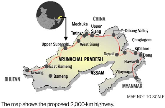
The 2,000-kilometre-long (1,200 mi) proposed Mago-Thingbu to Vijaynagar Arunachal Pradesh Frontier Highway along the McMahon Line,[7][8][9][10] (will intersect with the proposed East-West Industrial Corridor Highway) and will pass through this district, alignment map of which can be seen here and here.[11]
Demographics
Page Module:Historical populations/styles.css has no content.
| Year | Pop. | ±% p.a. |
|---|---|---|
| 1961 | 18,227 | — |
| 1971 | 41,474 | +8.57% |
| 1981 | 62,211 | +4.14% |
| 1991 | 95,530 | +4.38% |
| 2001 | 125,422 | +2.76% |
| 2011 | 148,226 | +1.68% |
| source:[12] | ||
According to the 2011 census Changlang district has a population of 148,226,[13] roughly equal to the nation of Saint Lucia.[14]
This gives it a ranking of 598th in India (out of a total of 640 districts). The district has a population density of 32 inhabitants per square kilometre (83/sq mi). Its population growth rate over the decade 2001–2011 was 17.96%. Changlang has a sex ratio of 914 females for every 1000 males, and a literacy rate of 61.9%. Scheduled Tribes made up 36.3% of the district's population.[13]
The largest group in the state are the Chakma and Hajong who were settled in the region after their home in the Chittagong Hill Tracts was flooded by the Kaptai Dam. They make up around a one-third of the district's population.[15] Another third is made up of tribal groups, namely Tangsa, Tutsa, Nocte, Chakma, Singpho, Galo, Gorkha and the Yobin. Sizeable communities of the Tibetans,[16] and Bodo are also there.
The Tibetan people are clustered at Choephelling Tibetan settlement in Miao, which was set up in 1976 hosts a population of 2200.[17]
Languages
| Language | Number of Speakers | Percentage |
|---|---|---|
| Chakma | 40,225 | 27.14% |
| Tangsa | 39,303 | 26.52% |
| Hindi | 14,900 | 10.05% |
| Nepali | 10,511 | 7.09% |
| Assamese | 5,183 | 3.50% |
| Bengali | 4,779 | 3.22% |
| Singpho | 3,965 | 2.67% |
| Monpa | 3,295 | 2.22% |
| Yobin | 2,979 | 2.01% |
| Hajong | 2,658 | 1.79% |
| Nocte | 2,452 | 1.65% |
| Ao | 1,716 | 1.16% |
| Deori | 1,450 | 0.98% |
| Khamti | 1,266 | 0.85% |
| Adi | 1,136 | 0.77% |
| Others | 12,408 | 8.37% |
At the time of the 2011 census, 27.14% of the population spoke Chakma, 20.08% Tangsa, 7.09% Nepali, 3.97% Sadri, 3.50% Assamese, 3.26% Hindi, 3.22% Bengali, 2.22% Monpa, 2.04% Bhojpuri, 1.79% Hajong, 1.65% Nocte and 1.13% Chungli Ao as their first language. Other significant languages in the district not recorded in the census are Singpho, spoken by c. 3900 people.[18]
Religion
Buddhism, followed predominantly by the Chakmas and the Singphos and Khamti, is the largest religion in the district and is practiced by around a third of the population. Other non-tribal communities, such as the Hajong, Nepalis, Bhojpuris, Assamese and others are Hindus, who make up around 32% of the population. Around half the tribals, including most of the Tangsa, Nocte, and other Naga groups, have converted to Christianity, but a large minority among these groups still practice their traditional animistic faith. Some have attempted to formalize this faith into a new spiritual movement called Rangfrah. Christianity is also practiced among some members of the tea garden tribes like Munda and Kurukh.
Tourism
Places to visit are World War II cemetery in Jairampur, Indo-Myanmar border town Nampong and Pangsau Pass. Another place of interest is Bordumsa where the rich culture of the Tais and Singpho exist. Namdapha National park has many tourist homes & picturesque areas.
Flora and fauna
The Namdapha Tiger reserve is located in Miao town of this district.
Health services
District Hospital is located in Changlang headquarters. Subdivisions and major Administrative circles have Community health Center or Primary health Center to take care of basic health needs.
References
Page Template:Reflist/styles.css has no content.
- ^ a b c d Page Module:Citation/CS1/styles.css has no content."District Census 2011". Census2011.co.in.
- ^ Changlan
- ^ Page Module:Citation/CS1/styles.css has no content.Law, Gwillim (25 September 2011). "Districts of India". Statoids. Retrieved 11 October 2011.
- ^ Page Module:Citation/CS1/styles.css has no content.Srivastava, Dayawanti, ed. (2010). "States and Union Territories: Arunachal Pradesh: Government". India 2010: A Reference Annual (54th ed.). New Delhi, India: Additional Director General, Publications Division, Ministry of Information and Broadcasting (India), Government of India. p. 1113. ISBN 978-81-230-1617-7.
- ^ Page Module:Citation/CS1/styles.css has no content."Island Directory Tables: Islands by Land Area". United Nations Environment Program. 18 February 1998. Retrieved 11 October 2011.
Lombok 4,625 km2
{{cite web}}: CS1 maint: deprecated archival service (link) - ^ Page Module:Citation/CS1/styles.css has no content."Assembly Constituencies allocation w.r.t District and Parliamentary Constituencies". Chief Electoral Officer, Arunachal Pradesh website. Archived from the original on 13 August 2011. Retrieved 21 March 2011.
- ^ Page Module:Citation/CS1/styles.css has no content.Dipak Kumar Dash (16 October 2014). "Top officials to meet to expedite road building along China border". The Times of India. Retrieved 27 October 2014.
- ^ Page Module:Citation/CS1/styles.css has no content."Narendra Modi government to provide funds for restoration of damaged highways". Retrieved 27 October 2014.
- ^ Page Module:Citation/CS1/styles.css has no content.Ankit Panda. "Indian Government Plans Highway Along Disputed China Border". thediplomat.com. Retrieved 27 October 2014.
- ^ Page Module:Citation/CS1/styles.css has no content."Govt planning road along McMohan line in Arunachal Pradesh: Kiren Rijiju". Live Mint. 14 October 2014. Retrieved 26 October 2014.
- ^ Page Module:Citation/CS1/styles.css has no content.Ajay Banerjee. "China warns India against paving road in Arunachal". tribuneindia.com. Retrieved 26 October 2014.
- ^ Decadal Variation In Population Since 1901
- ^ a b Page Module:Citation/CS1/styles.css has no content."District Census 2011". Census2011.co.in. 2011. Retrieved 30 September 2011.
- ^ Page Module:Citation/CS1/styles.css has no content.US Directorate of Intelligence. "Country Comparison:Population". Archived from the original on 13 June 2007. Retrieved 1 October 2011.
Saint Lucia 161,557 July 2011 est.
- ^ Page Module:Citation/CS1/styles.css has no content."Coronavirus | Row over inclusion of Chakmas in Arunachal infection tally". The Hindu. 6 June 2020. ISSN 0971-751X. Retrieved 22 January 2021.
- ^ Tibetans in Miao Elect Settlement Officer Script error: No such module "webarchive".. Tibet.net (24 October 2003).
- ^ Choepheling Tibetan Settlement, Miao, Arunachal Pradesh, India Script error: No such module "webarchive".
- ^ 2011 Census of India, Population By Mother Tongue
- ^ Page Module:Citation/CS1/styles.css has no content."Population by religion community – 2011". Census of India, 2011. The Registrar General & Census Commissioner, India. Archived from the original on 25 August 2015.
External links
Page Module:Side box/styles.css has no content.Page Template:Sister project/styles.css has no content.
Lua error in package.lua at line 80: module 'Module:Navbox/configuration' not found. Lua error in package.lua at line 80: module 'Module:Navbox/configuration' not found. Lua error in package.lua at line 80: module 'Module:Authority control/config' not found.



![[icon]](/index.php?title=Special:Upload&wpDestFile=Wiki_letter_w_cropped.svg)