Fara'ata
Script error: No such module "Settlement short description".Page Module:Infobox/styles.css has no content.Page Template:Infobox settlement/styles.css has no content.
Far'ata | |
|---|---|
| Arabic transcription(s) | |
| • Arabic | فرعتا |
| • Latin | Far'ata (unofficial) |
| Lua error in package.lua at line 80: module 'Module:InfoboxImage/data' not found. Far'ata | |
| Script error: No such module "Infobox mapframe". | |
| Lua error in Module:Location_map at line 526: Unable to find the specified location map definition: "Module:Location map/data/Palestine" does not exist. | |
| Coordinates: Lua error in package.lua at line 80: module 'Module:ISO 3166/data/PS' not found. | |
| Palestine grid | 165/177 |
| State | State of Palestine |
| Governorate | Qalqilya |
| Government | |
| • Type | Local Development Committee |
| Elevation | Script error: No such module "ConvertIB". |
| Population (2017)[2] | Template:Fix comma category |
| Population (2017)[2] | |
• Total | Template:Fix comma category |
| • Density | Script error: No such module "ConvertIB". |
| Template:Pluralize from text | Template:Pluralize from text |
| Template:Pluralize from text | Template:Pluralize from text |
| Name meaning | Ferata, p.n.[3] |
Script error: No such module "Check for conflicting parameters".
Far'ata (Template:Langx) was a Palestinian village in the Qalqilya Governorate in the Western area of the West Bank, located 16 kilometers Southwest of Nablus. According to the Palestinian Central Bureau of Statistics, the village had a population of 872 inhabitants in 2017.[2]
In 2012 Fara'ata was merged with the larger Immatain village council.[1]
Location
Immatin and Far’ata are located 19 kilometers (12 mi) west of Qalqiliya. They are bordered by Tell to the east, Deir Istiya to the south, Jinsafut, Al Funduq and Hajjah to the west, and Kafr Qaddum and Jit to the north.[1]
History
Byzantine ceramics have been found in the village.[4]
Fara'ata was noted in the Samaritan Chronicle (from the 12th century) under the name of Ophrah, while it has been known under its present name since the 14th century.[5]
Ottoman era
Far'ata was incorporated into the Ottoman Empire in 1517 with all of Palestine, and in 1596 it appeared in the tax registers as Fara'ta, being in the Nahiya of Jabal Qubal of the Liwa of Nablus. It had a population of 12 households and 6 bachelor, all Muslim. The villagers paid a fixed tax rate of 33,3% on a number of crops, including wheat, barley, summer crops, olive trees, goats and beehives, in addition to occasional revenues, a press for olive oil or grape syrup, and a fixed tax for people of Nablus area; a total of 4,500 Akçe.[6]
In 1838, Fer'ata was noted as located in Jurat Merda, south of Nablus.[7]
In 1870 the French explorer Victor Guérin visited Far'ata, which he described having "a very small number" of people, with some cisterns and remains of a stone sarcophagus as remnants of former history.[8]
In 1870/1871 (1288 AH), an Ottoman census listed the village with a population of 10 households in the nahiya (sub-district) of Jamma'in al-Awwal, subordinate to Nablus.[9]
In the PEF's Survey of Western Palestine (SWP) (1882), Far'ata was described as a "small village of ancient appearance, standing on a [..] mound, with a rock-cut tomb to the south, and a sacred Mukam to the east."[5]
British Mandate era
In the 1922 census of Palestine conducted by the British Mandate authorities, Far'ata had a population of 36, all Muslim,[10] increasing in the 1931 census to of 47 Muslims, in a total of 11 houses.[11]
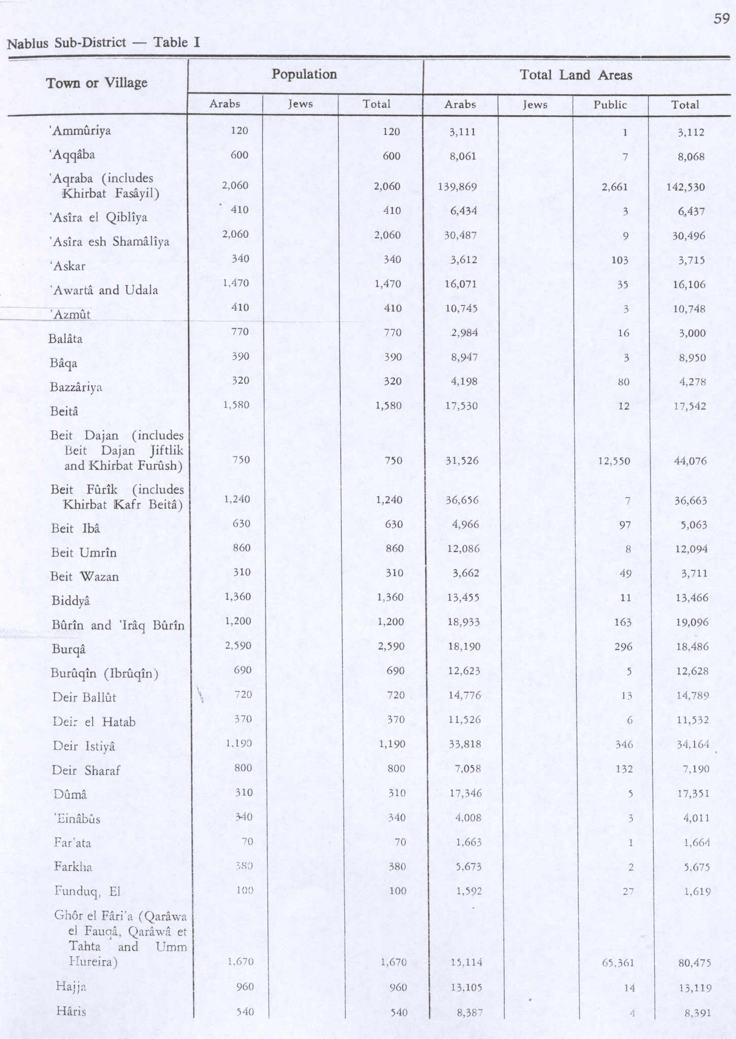
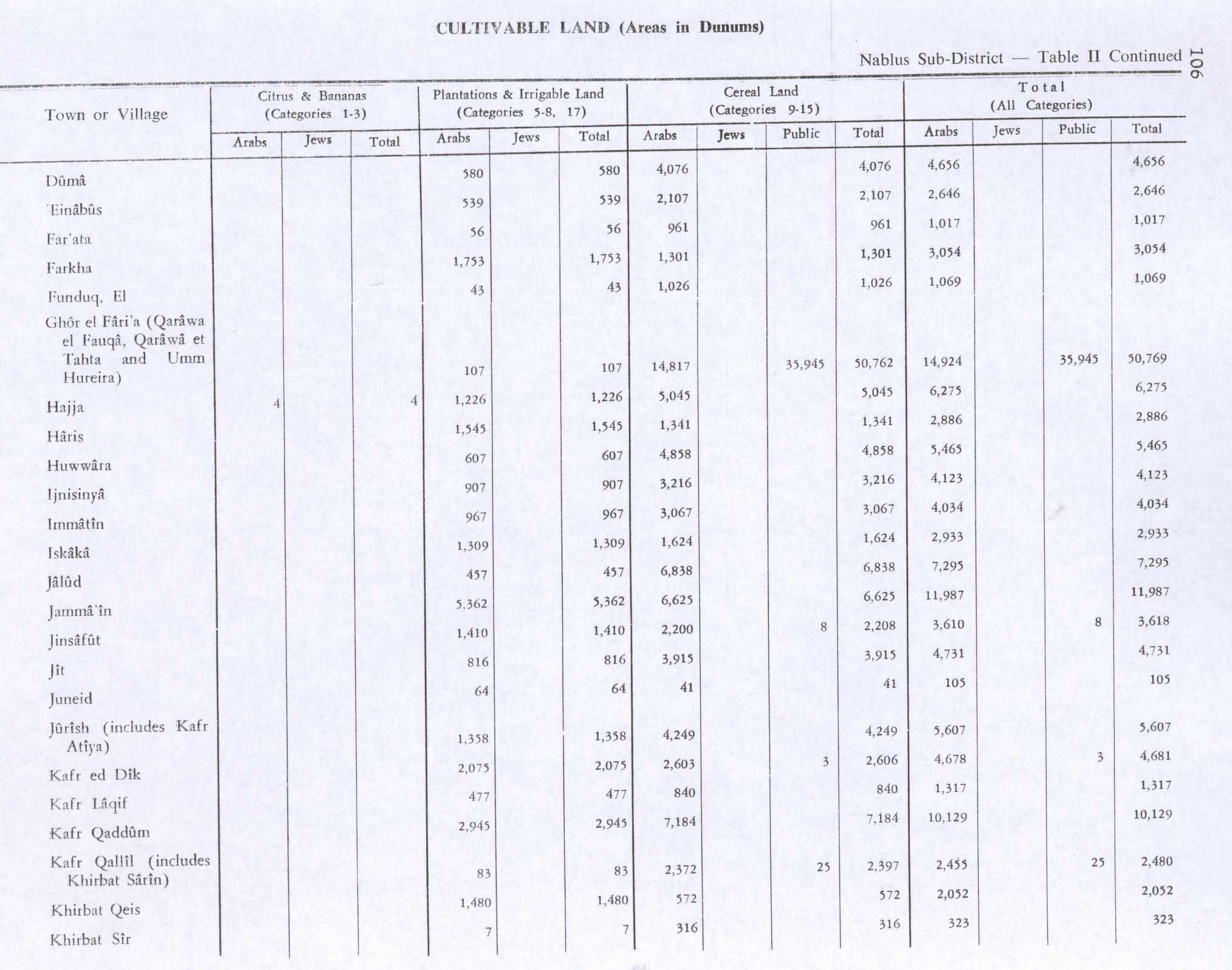
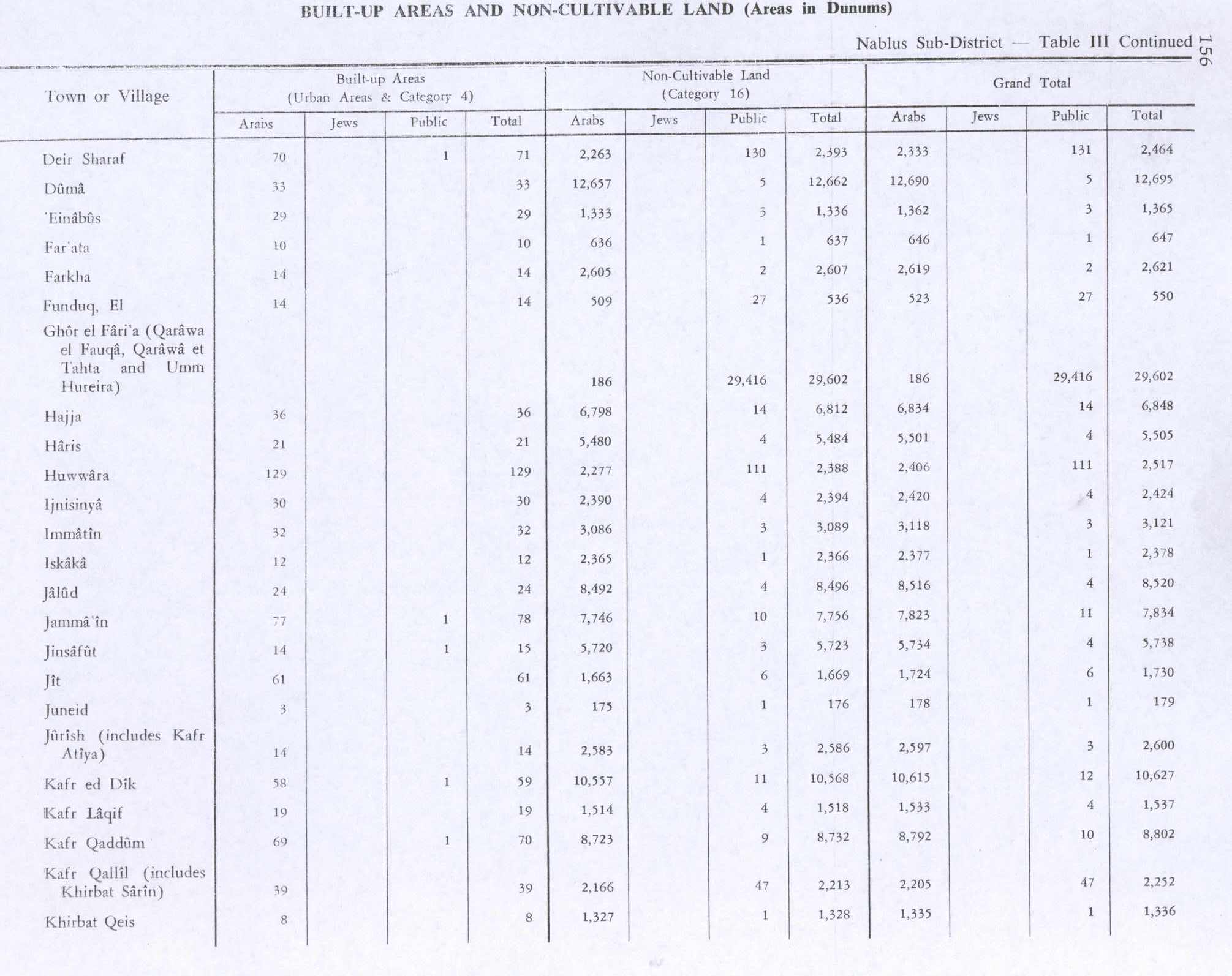
In the 1945 statistics the population of Far'ata was 70 Muslims,[12] while the total land area was 1,664 dunams, according to an official land and population survey.[13] Of this, 56 were allocated for plantations and irrigable land, 961 for cereals,[14] while 10 dunams were classified as built-up areas.[15]
Jordanian era
In the wake of the 1948 Arab–Israeli War, and after the 1949 Armistice Agreements, Far'ata came under Jordanian rule.
The Jordanian census of 1961 found 317 inhabitants in Faraata.[16]
Post-1967
Since the Six-Day War in 1967, Far'ata has been held under Israeli occupation.
After the 1995 accords, 58.3% of the total village land of Immatain/Far'ata was assigned as Area B land, while the remaining 41.7% is Area C land.[17]
In 2010, Far'ata was described by Gideon Levy as one of the Palestinian villages where the people "live in terror of the settlers and their accursed 'Price tag,' and nobody came to their defense".[18]
Demography
Local origins
Fara'ata's residents originally came from Immatain.[19]
References
Page Template:Reflist/styles.css has no content.
- ^ a b c Immatin Village Profile (including Far’ata Locality), ARIJ, p. 4
- ^ a b Page Module:Citation/CS1/styles.css has no content.Preliminary Results of the Population, Housing and Establishments Census, 2017 (PDF). Palestinian Central Bureau of Statistics (PCBS) (Report). State of Palestine. February 2018. pp. 64–82. Retrieved 2023-10-24.
- ^ Palmer, 1881, p. 182
- ^ Dauphin, 1998, p. 801
- ^ a b Conder and Kitchener, 1882, SWP II, pp. 162-163
- ^ Hütteroth and Abdulfattah, 1977, p. 133
- ^ Robinson and Smith, 1841, vol 3, Appendix 2, p. 127
- ^ Guérin, 1875, pp. 179 -180, cited in Conder and Kitchener, 1882, SWP II, p. 185
- ^ Page Module:Citation/CS1/styles.css has no content.Grossman, David (2004). Arab Demography and Early Jewish Settlement in Palestine. Jerusalem: Magnes Press. p. 251.
- ^ Barron, 1923, Table IX, Sub-district of Nablus, p. 25
- ^ Mills, 1932, p. 61
- ^ Government of Palestine, Department of Statistics, 1945, p. 18
- ^ Government of Palestine, Department of Statistics. Village Statistics, April, 1945. Quoted in Hadawi, 1970, p. 59
- ^ Government of Palestine, Department of Statistics. Village Statistics, April, 1945. Quoted in Hadawi, 1970, p. 106
- ^ Government of Palestine, Department of Statistics. Village Statistics, April, 1945. Quoted in Hadawi, 1970, p. 156
- ^ Government of Jordan, Department of Statistics, 1964, p. 26
- ^ Immatin Village Profile (including Far’ata Locality), ARIJ, p. 16
- ^ Twilight Zone / The mountain that was as a monster, Gideon Levy, May 20, 2010, Haaretz
- ^ Grossman, D. (1986). "Oscillations in the Rural Settlement of Samaria and Judaea in the Ottoman Period". in Shomron studies. Dar, S., Safrai, S., (eds). Tel Aviv: Hakibbutz Hameuchad Publishing House. p. 353
Bibliography
Page Template:Refbegin/styles.css has no content.
- Page Module:Citation/CS1/styles.css has no content.Barron, J.B., ed. (1923). Palestine: Report and General Abstracts of the Census of 1922. Government of Palestine.
- Page Module:Citation/CS1/styles.css has no content.Conder, C.R.; Kitchener, H.H. (1882). The Survey of Western Palestine: Memoirs of the Topography, Orography, Hydrography, and Archaeology. Vol. 2. London: Committee of the Palestine Exploration Fund.
- Page Module:Citation/CS1/styles.css has no content.Dauphin, C. (1998). La Palestine byzantine, Peuplement et Populations. BAR International Series 726 (in français). Vol. III : Catalogue. Oxford: Archeopress. ISBN 0-860549-05-4.
- Page Module:Citation/CS1/styles.css has no content.Government of Jordan, Department of Statistics (1964). First Census of Population and Housing. Volume I: Final Tables; General Characteristics of the Population (PDF).
- Page Module:Citation/CS1/styles.css has no content.Government of Palestine, Department of Statistics (1945). Village Statistics, April, 1945.
- Page Module:Citation/CS1/styles.css has no content.Guérin, V. (1875). Description Géographique Historique et Archéologique de la Palestine (in français). Vol. 2: Samarie, pt. 2. Paris: L'Imprimerie Nationale.
- Page Module:Citation/CS1/styles.css has no content.Hadawi, S. (1970). Village Statistics of 1945: A Classification of Land and Area ownership in Palestine. Palestine Liberation Organization Research Center.
- Page Module:Citation/CS1/styles.css has no content.Hütteroth, W.-D.; Abdulfattah, K. (1977). Historical Geography of Palestine, Transjordan and Southern Syria in the Late 16th Century. Erlanger Geographische Arbeiten, Sonderband 5. Erlangen, Germany: Vorstand der Fränkischen Geographischen Gesellschaft. ISBN 3-920405-41-2.
- Page Module:Citation/CS1/styles.css has no content.Mills, E., ed. (1932). Census of Palestine 1931. Population of Villages, Towns and Administrative Areas. Jerusalem: Government of Palestine.
- Page Module:Citation/CS1/styles.css has no content.Palmer, E.H. (1881). The Survey of Western Palestine: Arabic and English Name Lists Collected During the Survey by Lieutenants Conder and Kitchener, R. E. Transliterated and Explained by E.H. Palmer. Committee of the Palestine Exploration Fund.
- Page Module:Citation/CS1/styles.css has no content.Robinson, E.; Smith, E. (1841). Biblical Researches in Palestine, Mount Sinai and Arabia Petraea: A Journal of Travels in the year 1838. Vol. 3. Boston: Crocker & Brewster.
External links
- Welcome To Far'ata
- Survey of Western Palestine, Map 11: IAA, Wikimedia commons
- Immatin Village (including Far’ata Locality) (Fact Sheet), Applied Research Institute–Jerusalem (ARIJ)
- Immatin Village Profile (including Far’ata Locality), ARIJ
- Far’ata, aerial photo, ARIJ
- Development Priorities and Needs in Imatin (including Far’ata Locality), ARIJ
Lua error in package.lua at line 80: module 'Module:Navbox/configuration' not found.