Jinsafut
Script error: No such module "Settlement short description".Page Module:Infobox/styles.css has no content.Page Template:Infobox settlement/styles.css has no content.
Jinsafut | |
|---|---|
| Arabic transcription(s) | |
| • Arabic | جينصافوط |
| • Latin | Jensafut (official) |
| Lua error in package.lua at line 80: module 'Module:InfoboxImage/data' not found. Jinsafut, 2015 | |
| Script error: No such module "Infobox mapframe". | |
| Lua error in Module:Location_map at line 526: Unable to find the specified location map definition: "Module:Location map/data/Palestine" does not exist. | |
| Coordinates: Lua error in package.lua at line 80: module 'Module:ISO 3166/data/PS' not found. | |
| Palestine grid | 162/176 |
| State | File:Flag of Palestine.svg State of Palestine |
| Governorate | Qalqilya |
| Government | |
| • Type | Village council |
| Area | |
• Total | Script error: No such module "ConvertIB". |
| Elevation | Script error: No such module "ConvertIB". |
| Population (2017)[2] | Template:Fix comma category |
| Population (2017)[2] | |
• Total | Template:Fix comma category |
| • Density | Script error: No such module "ConvertIB". |
| Template:Pluralize from text | Template:Pluralize from text |
| Template:Pluralize from text | Template:Pluralize from text |
| Name meaning | Jinsafut[3] |
Script error: No such module "Check for conflicting parameters".
Jinsafut (Template:Langx, Jinṣāfūṭ) is a Palestinian village in the Qalqilya Governorate of the State of Palestine, in the northeastern West Bank, located east of Qalqilya.[4] According to the Palestinian Central Bureau of Statistics, the village had a population of 2,571 inhabitants in 2017.[2]
Fatah's Secretary-General Farouk Kaddoumi was born in Jinsafut.[5]
In 2012 it was decided that Jinsafut and Al-Funduq should be merged under one local council.[1]
Etymology
The name Jinsafut had varied spellings historically, reflecting different interpretations and transcriptions by records and researchers. The unique name of the village, absent from Arabic texts, suggests it retains an ancient title, as is common with numerous locations across the region of Palestine.[6]
According to one theory, Jinsafut may preserve the name of a town called Qiryat ha-Mishpaṭ, mentioned in a 14th-century Samaritan chronicle. The chronicle mentions the town being located across from a village known as ʿUskūr or ʿAskur, and indeed, to the east of Jinsafut, there exists a place called Khirbat ʿUskūr. This implies "Jinsafut" could have evolved from the Hebrew word "ha-Mishpaṭ" (המשפט), with "Qiryat" possibly being a Samaritan addition.[6]
Location
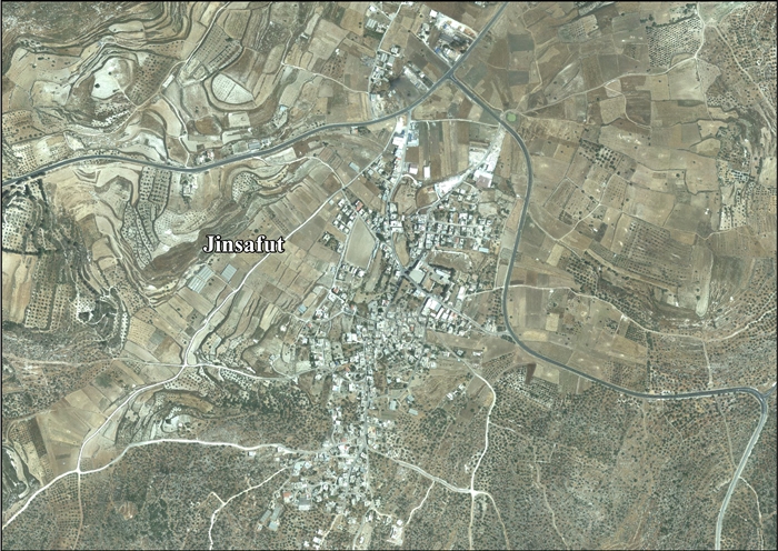
Jinsafut (including Al-Funduq) is located 16 kilometers (9.9 mi) east of Qalqiliya. It is bordered by Immatin to the east, Deir Istiya to the south, Wadi Qana (in Salfit Governorate) to the west and Hajja to the north.[1]
History
Early Islamic period
According to the Continuatio of the Samaritan Chronicle of Abu'l-Fath, During the reign of Abbasid Caliph al-Radi (935–940), Arabs from Jinsafut gathered and burned five Samaritans, all renowned in their villages, to death.[7]
Mamluk period
A construction text, over the lintel to a shrine known both as az-Zawiyah, and al Kihlwah, informs us that it was built by Mubarak Ibn Salih Alusi in the Mamluk era, in the year 791 AH, that is 1389 CE.[8][9]
Ottoman period
The place appeared in 1596 Ottoman tax registers as Jim Safut, being in the nahiya (subdistrict) of Bani Sa'b of the liwa (district) of Nablus. It had a population of 26 households, all Muslim. They paid a fixed tax-rate of 33.3% on agricultural products, including wheat barley, summer crops, olives, goats and beehives, and a press for olives or grapes; a total of 8,654 akçe.[10]
In 1838, Robinson noted Jin Safut as a village in Bani Sa'b.[11] In 1870 Victor Guérin described viewing the village from Fara'ata, but did not visit it.[12] In 1870/1871, an Ottoman census listed the village in the nahiya (subdistrict) of Bani Sa'b.[13] In 1882, the Palestine Exploration Fund's Survey of Western Palestine described the village as "a small village on high ground, with wells to the north, and a few olives."[14]
British Mandate era
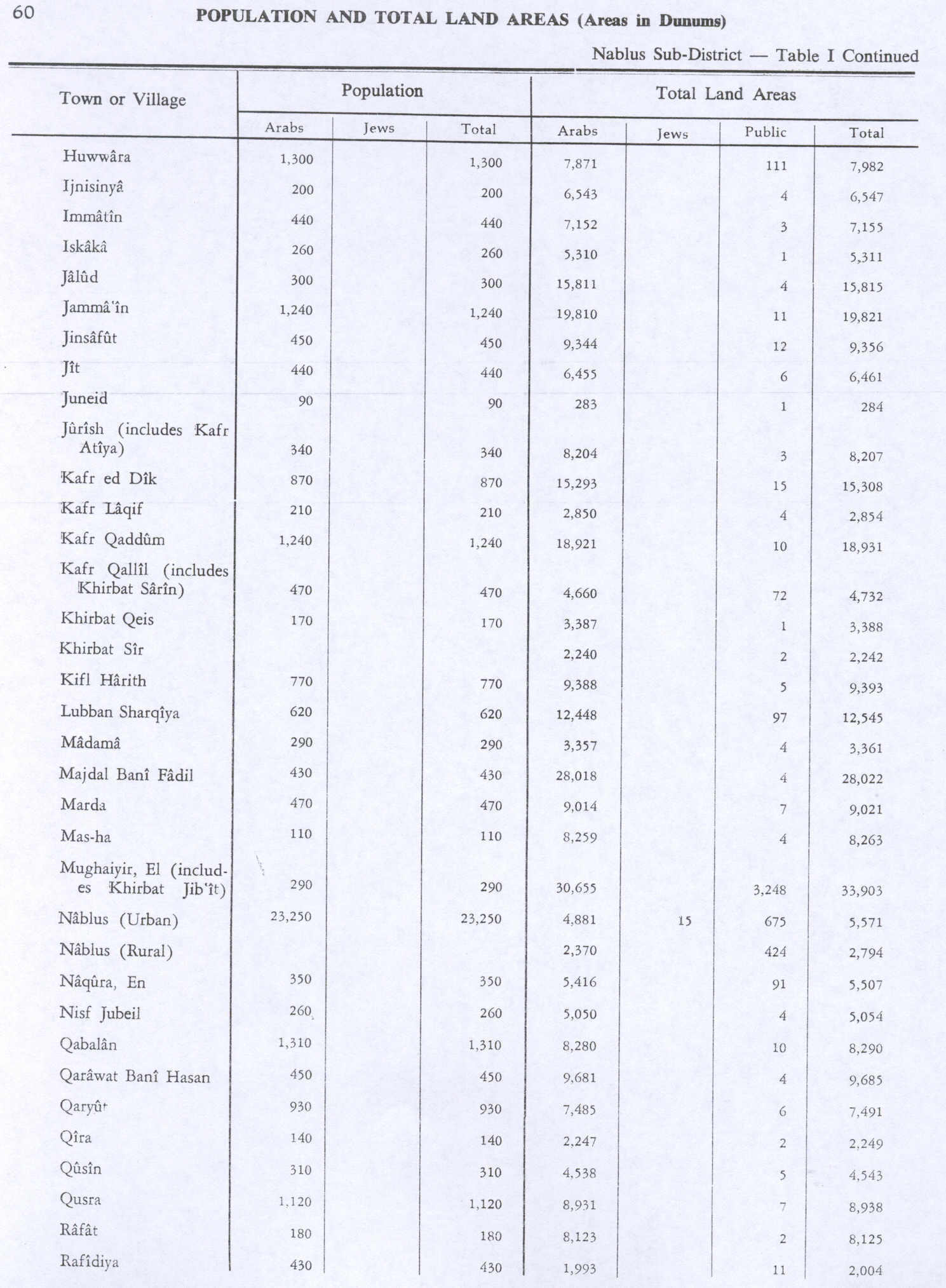
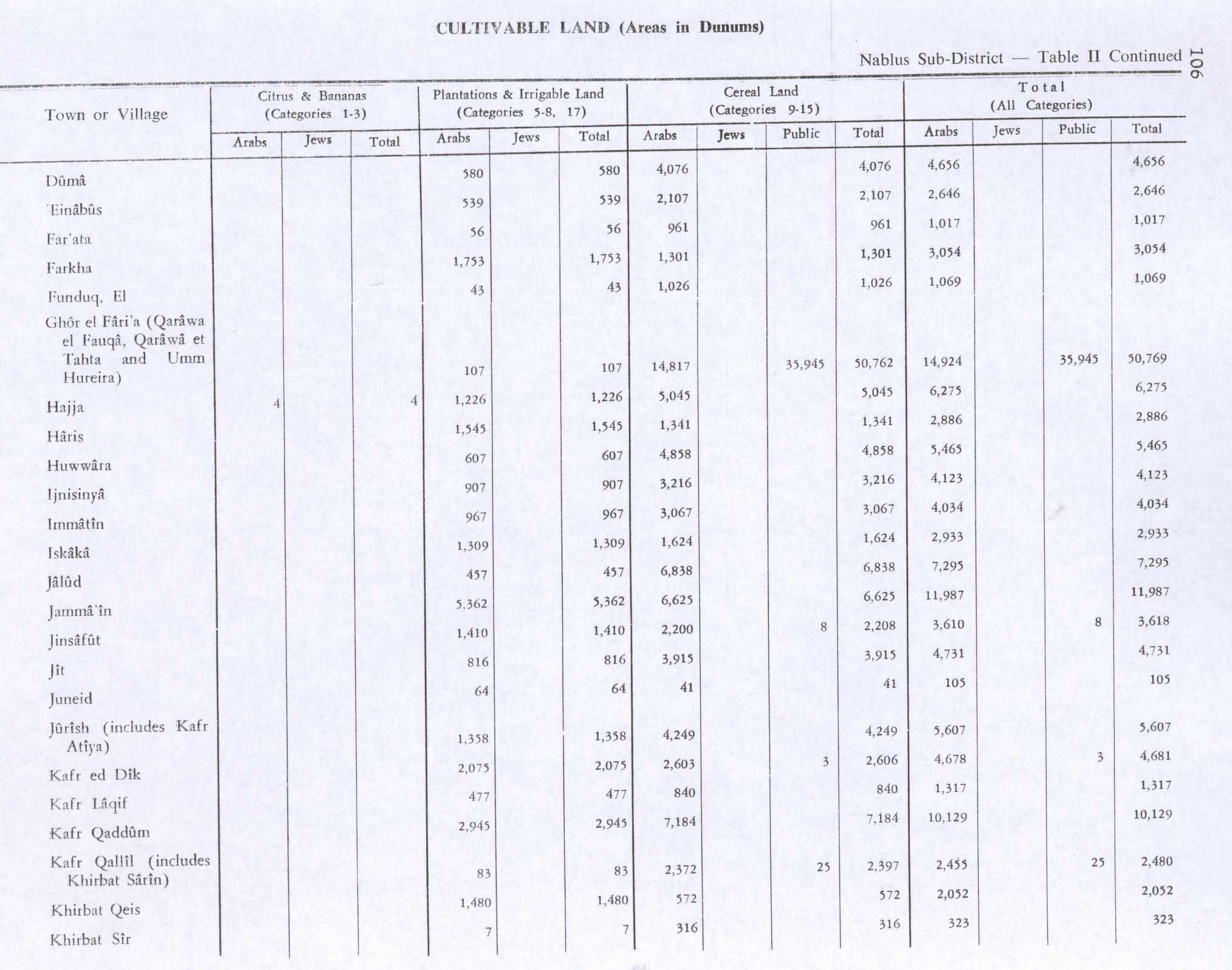
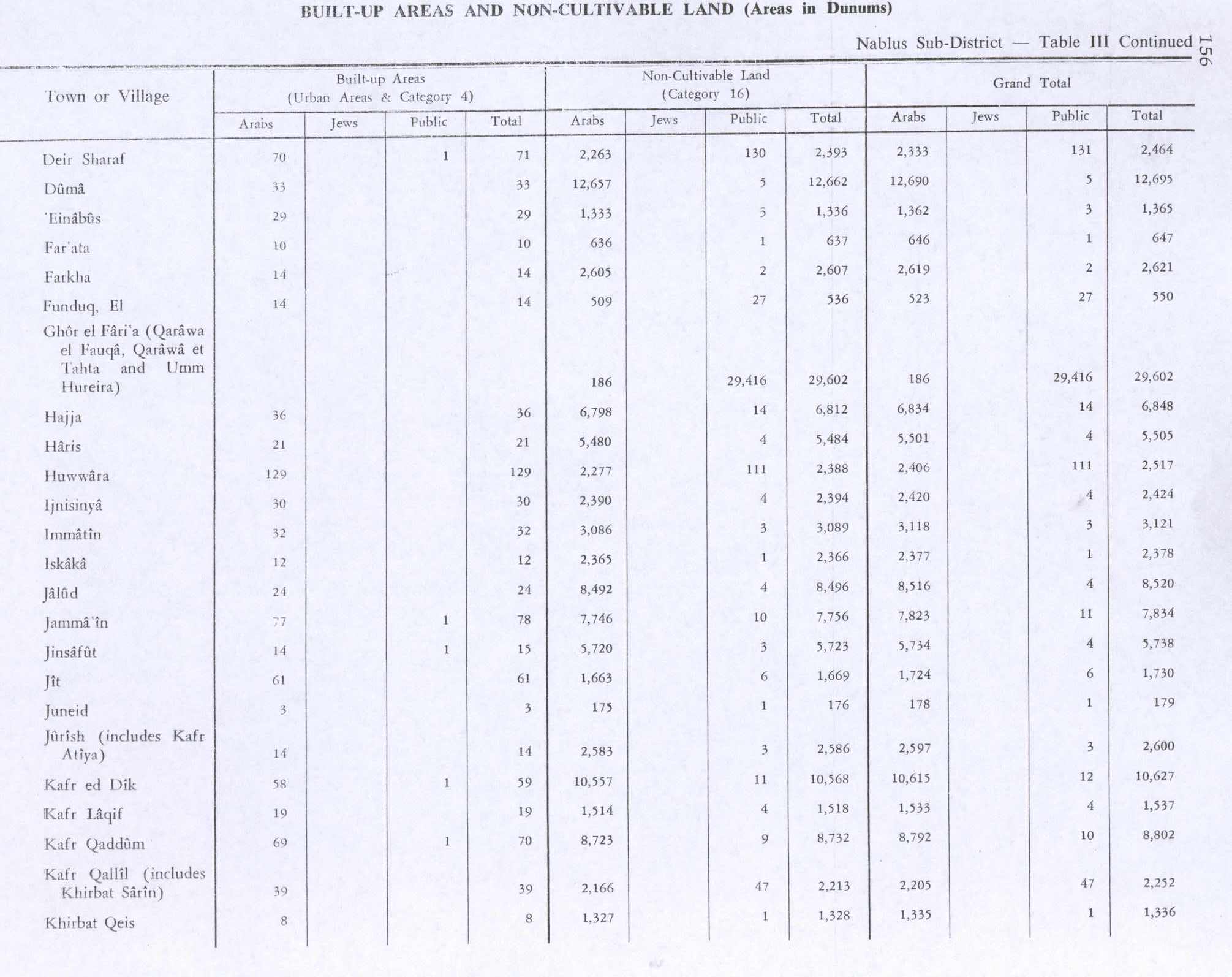
In the 1922 census of Palestine conducted by the British Mandate authorities, Jinsafut had a population of 267 inhabitants, all Muslims,[15] increasing in the 1931 census to 315 Muslims, with 76 houses.[16] In the 1945 census the population was 450 Muslims,[17] with 9,356 dunams of land, according to an official land and population survey.[18] Of this, 1,410 dunams were for plantations or irrigated land, 2,208 for cereals,[19] while 14 dunams were built-up (urban) land.[20]
Jordanian era
In the wake of the 1948 Arab–Israeli War, and after the 1949 Armistice Agreements, Jinsafut came under Jordanian rule. It was annexed by Jordan in 1950. The Jordanian census of 1961 found 729 inhabitants in Jinsafut.[21]
1967-present
Since the Six-Day War in 1967, Jinsafut has been under Israeli occupation. After the 1995 accords, 4.8% of Jinsafut and Al-Funduq land was classified as Area B, the remaining 95.2% is Area C.[22] Israel has expropriated 713 dunums of land from Jinsafut in order to establish two Israeli settlements; Karne Shomron and Neve Oramin.[22]
Places of Interest
Jinsafut houses two sanctuaries dedicated to local holy men: Shaykh Aḥmad in the north and Shaykh Abū Saʿīd in the south.[6]
Centrally located in the village is a khilwah (according to Husseni) or zāwiyah (according to Mayer), both terms denoting a small sanctuary dedicated to private meditation. At its entrance there is a marble slab dating back to 1389, bearing an inscription commemorating its construction by Mubārak Ibn Ṣāliḥ Alūsī. This inscription, accompanied by a heraldic shield, signifies Mubārak's status as a free and esteemed Muslim official, likely serving as a cup-bearer to the sultan, maybe the Mamluk sultan Barquq.[6]
Demographics
The village's residents have their origins in Kafr Qallil and Kafr Qaddum.[23] Some families of Jinsafut include al-Ayoub, al-Sukar, al-Saber, al-Allan, al-Nassar, al-Bashir and Eid.[24]
Prior to 1967, Jinsafut had a population of 700, which decreased to 550 after the 1967 Six-Day War; the drop was caused by residents fleeing the village to Jordan. According to a PCBS estimate, the village had grown to 2,122 inhabitants in 2003, then rose to 2,280 in 2006.[4]
Economy
Before 1967, 99.5% of Jinsafut's labor force depended agriculture, particularly on peach and grape crops, as well as raising livestock. The remainder worked in civil jobs. From 1967 to 2002, 91% of the village residents depended on agriculture or working in Israel, 6% were employed in the Palestinian National Authority government and 3% worked in commerce. Since the beginning of the Second Intifada, vehicle movement in Jinsafut has been constricted by Israel, contributing to 93% of the working population being unemployed.[4]
According to the Applied Research Institute - Jerusalem, Jinsafut has a land area of 9,335 dunams; 31.8% is used for growing crops, 4.3% are for heterogeneous agricultural areas, 1.9% for herbaceous vegetation associations, 5.2% is designated as arable land, 3% is built-up area, 8% is used for land for Israeli settlements and the remainder is forest area.[4]
References
Page Template:Reflist/styles.css has no content.
- ^ a b c Jinsafut Village Profile (including Al Funduq Locality), ARIJ, p. 4
- ^ a b Page Module:Citation/CS1/styles.css has no content.Preliminary Results of the Population, Housing and Establishments Census, 2017 (PDF). Palestinian Central Bureau of Statistics (PCBS) (Report). State of Palestine. February 2018. pp. 64–82. Retrieved 2023-10-24.
- ^ Palmer, 1881, p. 183
- ^ a b c d The Segregation Wall hits more Palestinian lands in Qalqilyia district Script error: No such module "webarchive". Land Research Center (LRC) & The Applied Research Institute-Jerusalem (ARIJ). 2004-06-15.
- ^ Biographies of Palestinian political leaders Script error: No such module "webarchive". Middle East Reference.
- ^ a b c d Page Module:Citation/CS1/styles.css has no content.Sharon, Moshe (2017-01-01), "Jinṣāfūṭ", Corpus Inscriptionum Arabicarum Palaestinae, Volume Six: -J (1)-, Brill, pp. 201–203, doi:10.1163/9789004325159_010, ISBN 978-90-04-32515-9, retrieved 2024-02-18
{{citation}}: CS1 maint: work parameter with ISBN (link) - ^ Page Module:Citation/CS1/styles.css has no content.Levy-Rubin, Milka (2002). "The Samaritans during the Early Muslim Period according to the Continuatio to the Chronicle of Abu 'l-Fath". In Stern, Ephraim; Eshel, Hanan (eds.). The Samaritans (in עברית). Yad Ben-Zvi Press. p. 579. ISBN 965-217-202-2.
- ^ Mayer, 1933, p. 157 and plate xxiv, #3
- ^ Sharon, 2016, pp. 201-203
- ^ Hütteroth and Abdulfattah, 1977, p. 139
- ^ Robinson and Smith, 1841, vol 3, Appendix 2, p. 127
- ^ Guérin, 1875, p. 180
- ^ Page Module:Citation/CS1/styles.css has no content.Grossman, David (2004). Arab Demography and Early Jewish Settlement in Palestine. Jerusalem: Magnes Press. p. 255.
- ^ Conder and Kitchener, 1882, SWP II, p. 164
- ^ Barron, 1923, Table IX, Sub-district of Nablus, p. 25
- ^ Mills, 1932, p. 62
- ^ Government of Palestine, Department of Statistics, 1945, p. 18
- ^ Government of Palestine, Department of Statistics. Village Statistics, April, 1945. Quoted in Hadawi, 1970, p. 60
- ^ Government of Palestine, Department of Statistics. Village Statistics, April, 1945. Quoted in Hadawi, 1970, p. 106
- ^ Government of Palestine, Department of Statistics. Village Statistics, April, 1945. Quoted in Hadawi, 1970, p. 156
- ^ Government of Jordan, Department of Statistics, 1964, p. 25
- ^ a b Jinsafut Village Profile (including Al Funduq Locality), ARIJ, p. 17
- ^ Grossman, D. (1986). "Oscillations in the Rural Settlement of Samaria and Judaea in the Ottoman Period". in Shomron studies. Dar, S., Safrai, S., (eds). Tel Aviv: Hakibbutz Hameuchad Publishing House. p. 353
- ^ Hundreds of olive trees burned by Israeli settlers in Jinsafut Village Script error: No such module "webarchive". Land Research Center. 2007-10-01.
Bibliography
Page Template:Refbegin/styles.css has no content.
- Page Module:Citation/CS1/styles.css has no content.Barron, J.B., ed. (1923). Palestine: Report and General Abstracts of the Census of 1922. Government of Palestine.
- Page Module:Citation/CS1/styles.css has no content.Conder, C.R.; Kitchener, H.H. (1882). The Survey of Western Palestine: Memoirs of the Topography, Orography, Hydrography, and Archaeology. Vol. 2. London: Committee of the Palestine Exploration Fund.
- Page Module:Citation/CS1/styles.css has no content.Government of Jordan, Department of Statistics (1964). First Census of Population and Housing. Volume I: Final Tables; General Characteristics of the Population (PDF).
- Page Module:Citation/CS1/styles.css has no content.Government of Palestine, Department of Statistics (1945). Village Statistics, April, 1945.
- Page Module:Citation/CS1/styles.css has no content.Guérin, V. (1875). Description Géographique Historique et Archéologique de la Palestine (in français). Vol. 2: Samarie, pt. 2. Paris: L'Imprimerie Nationale.
- Page Module:Citation/CS1/styles.css has no content.Hadawi, S. (1970). Village Statistics of 1945: A Classification of Land and Area ownership in Palestine. Palestine Liberation Organization Research Center.
- Page Module:Citation/CS1/styles.css has no content.Hütteroth, W.-D.; Abdulfattah, K. (1977). Historical Geography of Palestine, Transjordan and Southern Syria in the Late 16th Century. Erlanger Geographische Arbeiten, Sonderband 5. Erlangen, Germany: Vorstand der Fränkischen Geographischen Gesellschaft. ISBN 3-920405-41-2.
- Page Module:Citation/CS1/styles.css has no content.Mayer, L.A. (1933). Saracenic Heraldry: A Survey. Oxford: Oxford University Press.
- Page Module:Citation/CS1/styles.css has no content.Mills, E., ed. (1932). Census of Palestine 1931. Population of Villages, Towns and Administrative Areas. Jerusalem: Government of Palestine.
- Page Module:Citation/CS1/styles.css has no content.Palmer, E.H. (1881). The Survey of Western Palestine: Arabic and English Name Lists Collected During the Survey by Lieutenants Conder and Kitchener, R. E. Transliterated and Explained by E.H. Palmer. Committee of the Palestine Exploration Fund.
- Page Module:Citation/CS1/styles.css has no content.Robinson, E.; Smith, E. (1841). Biblical Researches in Palestine, Mount Sinai and Arabia Petraea: A Journal of Travels in the year 1838. Vol. 3. Boston: Crocker & Brewster.
- Page Module:Citation/CS1/styles.css has no content.Sharon, M. (2016). Corpus Inscriptionum Arabicarum Palaestinae, J (I). Vol. 6. BRILL. ISBN 978-90-04-32479-4.
External links
- Welcome To Jinsafut
- Jinsafut, Welcome to Palestine
- Survey of Western Palestine, Map 11: IAA, also on Wikimedia Commons
- Jinsafut Village (including Al Funduq Locality) (Fact Sheet), Applied Research Institute–Jerusalem (ARIJ)
- Jinsafut Village Profile (including Al Funduq Locality), ARIJ
- Jinsafut, aerial photo, ARIJ
- The Segregation Wall hits more Palestinian lands in Qalqilyia district, 15, June, 2004, ARIJ
- Tree uprooting and colonial expansion in Jinsafut village, 04, June, 2005, ARIJ
- Talk of Churchills and Chamberlains, By Akiva Eldar, Haaretz, May.16, 2006
- Demolition Warnings in Jinsafut Village - Qalqlyiah Governorate, 24, February, 2007, ARIJ
- Hundreds of olive trees burned by Israeli settlers in Jinsafut Village, 01, October, 2007, ARIJ
- Ravaging 60 trees in Jinsafut village in Qalqiliya 15, January, 2012, ARIJ
Lua error in package.lua at line 80: module 'Module:Navbox/configuration' not found. Lua error in package.lua at line 80: module 'Module:Authority control/config' not found.