Murchison Dam
Template:Short description Template:DMCA Template:DMCA
Script error: No such module "Type in location".Page Module:Infobox/styles.css has no content.
| Murchison Dam | |
|---|---|
| Lua error in package.lua at line 80: module 'Module:InfoboxImage/data' not found. | |
| Lua error in Module:Location_map at line 526: Unable to find the specified location map definition: "Module:Location map/data/Tasmania" does not exist. | |
| Script error: No such module "Infobox mapframe". | |
| Country | Australia |
| Location | Western Tasmania |
| Coordinates | Lua error: callParserFunction: function "#coordinates" was not found. |
| Purpose | Power |
| Status | Operational |
| Construction began | Script error: No such module "Date time". |
| Opening date | Script error: No such module "Date time". |
| Built by | Hydro-Electric Commission (TAS) |
| OwnerTemplate:Pluralize from text | Hydro Tasmania |
| Dam and spillways | |
| Type of dam | Rock-fill dam |
| Impounds | Murchison River |
| Height (foundation) | Template:Cvt |
| Length | Template:Cvt |
| Dam volume | Template:Cvt |
| Spillways | 1 |
| Spillway type | Uncontrolled |
| Spillway length | Template:Cvt |
| Spillway capacity | Template:Cvt |
| Reservoir | |
| Creates | Lake Murchison |
| Total capacity | Template:Cvt |
| Catchment area | Template:Cvt |
| Surface area | Template:Cvt |
| Normal elevation | Template:Cvt |
| [1][2] | |
Expression error: Unexpected < operatorScript error: No such module "Check for conflicting parameters".
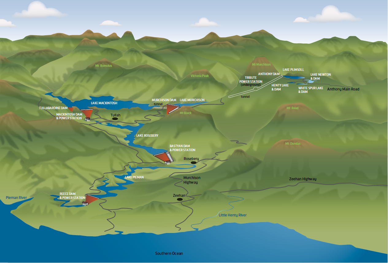
The Murchison Dam is a concrete-faced rock-filled embankment dam across the Murchison River, located near Tullah, within the northern part of the West Coast Range, in the western region of Tasmania, Australia. Completed in 1982 by the Hydro-Electric Commission (TAS), the resultant reservoir, Lake Murchison, was created for the purposes of generation of hydroelectricity as part of the Pieman Power Development. In addition to impounding the Murchison River, the dam's reservoir is also fed by the George Creek, the Anthony River, and discharge from the Tribute Power Station.
The dam is owned and operated by Hydro Tasmania.
Location and features
The concrete-faced rock-filled dam wall is 93 metres (305 ft) high and 217 metres (712 ft) long. When full, the reservoir has capacity of 96,910 megalitres (78,570 acre⋅ft) and covers 408 to 450 hectares (1,010 to 1,110 acres), drawn from a catchment area of 750 square kilometres (290 sq mi). The uncontrolled spillway has a flow capacity of 1,910 cubic metres per second (67,000 cu ft/s).[1][3] The spillway is 13 metres (43 ft) wide at the base, 10 metres (33 ft) high, 160 metres (520 ft) long, and is cut into dolerite bedrock.[4]
Water from Lake Murchison is diverted to Lake Mackintosh and the Mackintosh Power Station by the 2-kilometre-long (1.2 mi) Sophia Tunnel,[5] as part of the Pieman power development that was completed in 1987.[6]
Upstream of the Murchison Dam is the White Spur Lake and dam, Henty Dam and its reservoir, Lake Newton and dam, Lake Plimsoll and Anthony Dam, and the Tribute Power Station. Downstream from the Murchison Dam is Lake Mackintosh, Tullabardine Dam, Mackintosh Dam, Mackintosh Power Station, Lake Rosebery, Bastyan Dam, Bastyan Power Station, Lake Pieman, Reece Dam and the Reece Power Station.
Hydro Tasmania completed an Template:AUD upgrade of the dam wall and spillway to improve flood capacity. The crest wall was raised by 3 metres (9.8 ft), completed in 2020; and the spillway's right chute wall was raised between 2 to 5 metres (6 ft 7 in to 16 ft 5 in), completed in 2025. Given the remote location of the dam wall, access to the facility proved challenging.[4][7][8][9]
Etymology
The name of the dam is derived from the Murchison River and the adjacent Mount Murchison.
See also
Page Template:Stack/styles.css has no content.
References
Page Template:Reflist/styles.css has no content.
- ^ a b Page Module:Citation/CS1/styles.css has no content."Register of Large Dams Australia-2015" (Excel. Requires download. Row 370). ANCOLD. January 2022. Retrieved 5 March 2026.
- ^ Page Module:Citation/CS1/styles.css has no content."Map of Lake Murchison, TAS". Bonzle Digital Atlas of Australia. n.d. Retrieved 21 June 2015.
- ^ Page Module:Citation/CS1/styles.css has no content."West Coast power stations | Pieman power scheme". Hydro Tasmania. 2026. Retrieved 21 April 2026.
- ^ a b Page Module:Citation/CS1/styles.css has no content."Upgrading Murchison Dam". International Water Power and Dam Construction. 5 September 2024. Retrieved 21 April 2026.
- ^ Page Module:Citation/CS1/styles.css has no content."The Pieman Catchment". Hydro Tasmania. Archived from the original on 4 December 2004. Retrieved 21 April 2026.
- ^ Page Module:Citation/CS1/styles.css has no content.Project Pieman: Murchison (Map). Hydro-Electric Commission and the Dept. of Lands and Surveys (Tasmania). 1970. Sheet 51. § C. Retrieved 9 June 2015 – via Trove. National Library of Australia.
- ^ Page Module:Citation/CS1/styles.css has no content."$31 million upgrade for West Coast's Murchison Dam". Hydro Tasmania. 23 May 2025. Retrieved 21 April 2026.
- ^ Page Module:Citation/CS1/styles.css has no content."Lua error in package.lua at line 80: module 'Module:GetParameters' not found.". Hazel Brothers. 2025. Retrieved 21 April 2026.
- ^ Page Module:Citation/CS1/styles.css has no content.Giudici, Oliver (20 March 2024). "News from Tasmania – Murchison Dam Spillway Upgrade". ANCOLD. Retrieved 21 April 2026.
External links
- Page Module:Citation/CS1/styles.css has no content.Pieman catchment (Map). Hydro Tasmania. 2018.[dead link]
- Page Module:Citation/CS1/styles.css has no content.Stephenson, David (1982). Murchison River and debris before flooding of Lake Murchison, Tasmania (3 gelatin silver photographs). Retrieved 21 April 2026 – via Art Gallery of New South Wales.
Template:Dams in Tasmania Lua error in package.lua at line 80: module 'Module:Navbox/configuration' not found. Lua error in package.lua at line 80: module 'Module:Navbox/configuration' not found.