Sakhnin
Template:Short description Template:Pp
Script error: No such module "Settlement short description".Page Module:Infobox/styles.css has no content.Page Template:Infobox settlement/styles.css has no content.
Sakhnin
Page Template:Hlist/styles.css has no content.
| |
|---|---|
City (from 1995) | |
| Hebrew transcription(s) | |
| • ISO 259 | Saḥnin, Saknin (Israeli pronunciation) |
| Lua error in package.lua at line 80: module 'Module:InfoboxImage/data' not found. View of Sakhnin | |
| Page Template:Infobox settlement/columns/styles.css has no content.
Lua error in package.lua at line 80: module 'Module:InfoboxImage/data' not found. Emblem of Sakhnin | |
| Script error: No such module "Infobox mapframe". | |
| Lua error in Module:Location_map at line 526: Unable to find the specified location map definition: "Module:Location map/data/Israel northwest" does not exist. | |
| Coordinates: Lua error: callParserFunction: function "#coordinates" was not found. | |
| Grid position | 177/252 PAL |
| Country | File:Flag of Israel.svg Israel |
| District | Northern |
| Founded | 1500 BCE (as Sagone) 1995 (Israeli city) |
| Government | |
| • Mayor | Mazen Ghnaim |
| Area | |
• Total | Script error: No such module "ConvertIB". |
| Population (2024)[1] | Template:Fix comma category |
| Population (2024)[1] | |
• Total | Template:Fix comma category |
| • Density | Script error: No such module "ConvertIB". |
| Template:Pluralize from text | Template:Pluralize from text |
| Template:Pluralize from text | Template:Pluralize from text |
| Name meaning | Sukhnin, from personal name,[2] |
Script error: No such module "Check for conflicting parameters".
Sakhnin (Template:Langx; Template:Langx or Page Template:Script/styles hebrew.css has no content.סִכְנִין Sikhnin) is a city in Israel's Northern District. It is located in the Lower Galilee, about 23 kilometres (14 mi) east of Acre. Sakhnin was declared a city in 1995. In 2024 its population was 33,728;[1] 95% of the population was Muslim and 5% was Christian.[3]
Geography
Sakhnin is built over three hills and is located in a valley surrounded by mountains, the highest one being 602 meters high. Its rural landscape is almost entirely covered by olive and fig groves as well as oregano and sesame shrubs.
History
Settlement at Sakhnin dates back 3,500 years to its first mention in 1479 BCE by Thutmose II, whose ancient Egyptian records mention it as a centre for production of indigo dye.
Sakhnin is situated on an ancient site, where remains from columns and cisterns have been found.[4] It was mentioned as Sogane, a town fortified in 66, by Josephus.[5] A cistern, excavated near the mosque in the old city centre, revealed pottery fragments dating from the 1st to the 5th century CE.[6]
Haninah ben Teradion, who was arrested by the Roman authorities for heresy (minut),[7] is said to have run a Torah academy there. It may be the village Kfar Sikhnin referred to in rabbinical accounts of the aftermath of the trial of Rabbi Eliezer ben Hyrcanus for heresy.[8]
In 1961 Bellarmino Bagatti, during a visit to the village, was shown a tomb venerated by Christians, Jews and Muslims, which local tradition identified as that of James the Just. On returning to the village, he discovered that restoration had been undertaken and the site renamed the burial place of Rabbi Yehoshua of Sakhnin. Richard Bauckham has raised the possibility that the Yaakov of Sikhnin in accounts of rabbi Eliezer may be James the grandson of Jude.[9]
In the Crusader era, it was known as Zecanin.[10] In 1174 it was one of the casalia (villages) given to Phillipe le Rous.[11] In 1236 descendants of Phillipe le Rous confirmed the sale of the fief of Saknin.[12]
Ottoman era
In 1596, Sakhnin appeared in Ottoman tax registers as being in the nahiya (subdistrict) of Akka (Acre), part of Safad Sanjak. It had a population of 66 households and 8 bachelors, all Muslim. The villagers paid a fixed tax rate of 20% on various agricultural products, including wheat, barley, olives, cotton, in addition to a water mill; a total of 12,138 akçe.[13][14]
In 1838, Sakhnin was noted as a Muslim and Christian village in the Shaghur district, located between Safad, Acre and Tiberias.[15] In 1859 the British Consul Rogers estimated the population to be 1,100, and the cultivated area 100 feddans,[16] while in 1875 Victor Guérin found 700 inhabitants, both Muslims and Greek Orthodox Christians.[17]
In 1881, the PEF's Survey of Western Palestine (SWP) described Sakhnin as follows: "A large village of stone and mud, amid fine olive-groves, with a small mosque. The water supply is from a large pool about half a mile to the south-east. The inhabitants are Moslems and Christians".[18] A population list from about 1887 showed that Sakhnin had about 1,915 inhabitants; 1,640 Muslims, 150 Catholic Christians and 125 Greek Christians.[19]
British Mandate era
In the 1922 census of Palestine conducted by the British Mandate authorities, Sakhnin had a population of 1,575; 1,367 Muslims and 208 Christians;[20] 87 Orthodox and 121 Greek Catholic (Melchite).[21] The population increased in the 1931 census to a total of 1,891; 1,688 Muslims, 202 Christians, and 1 Jew, in a total of 400 houses.[22]
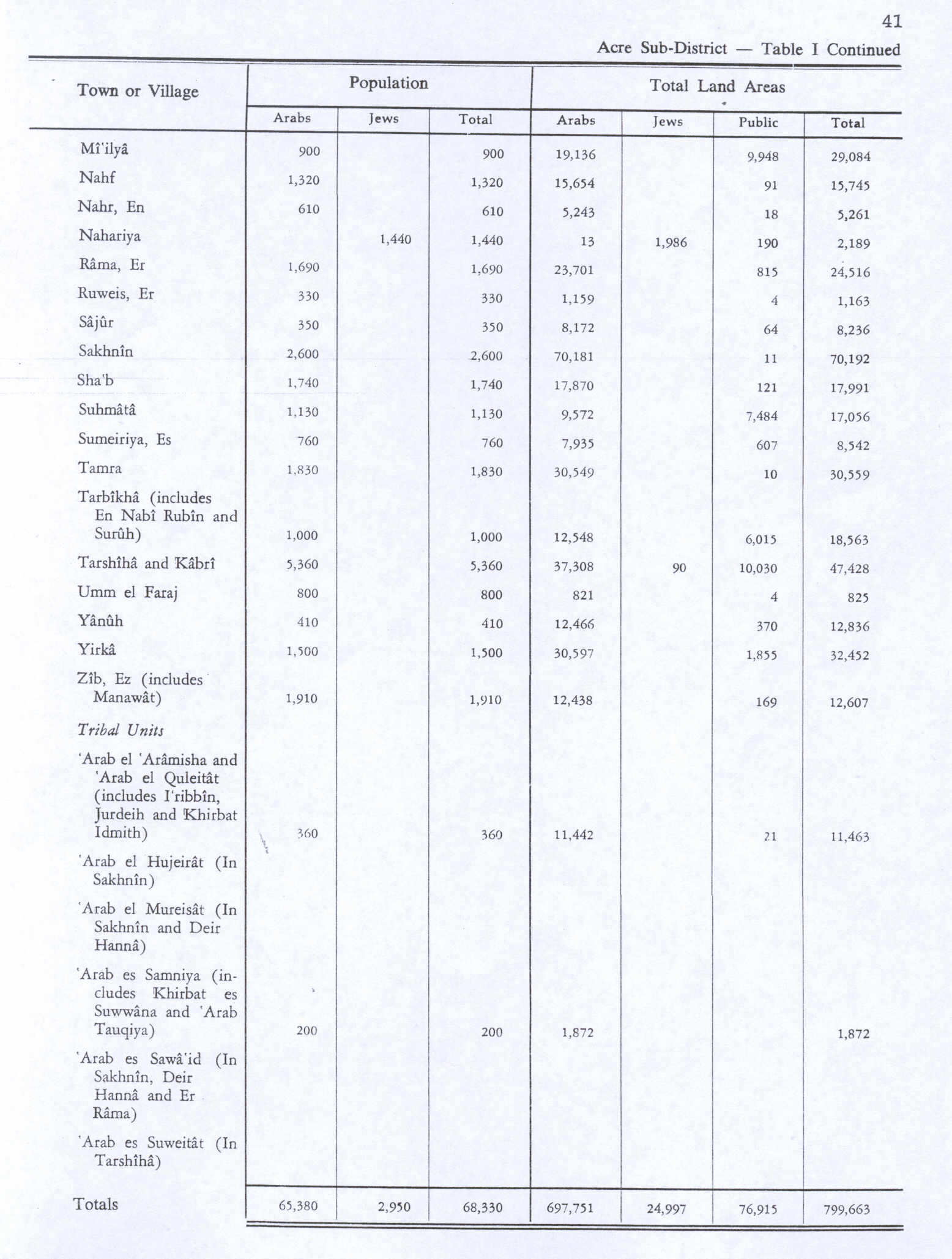
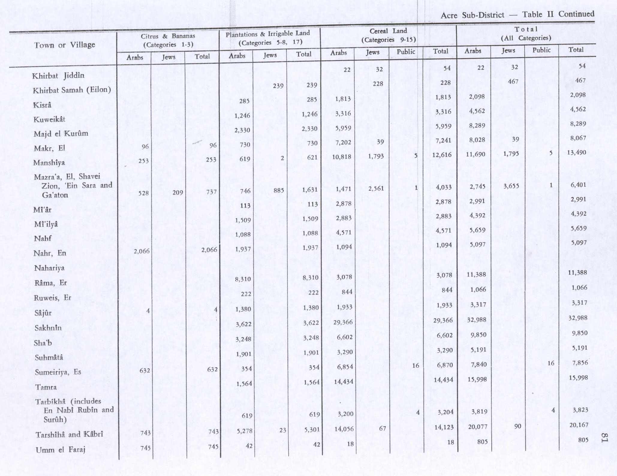
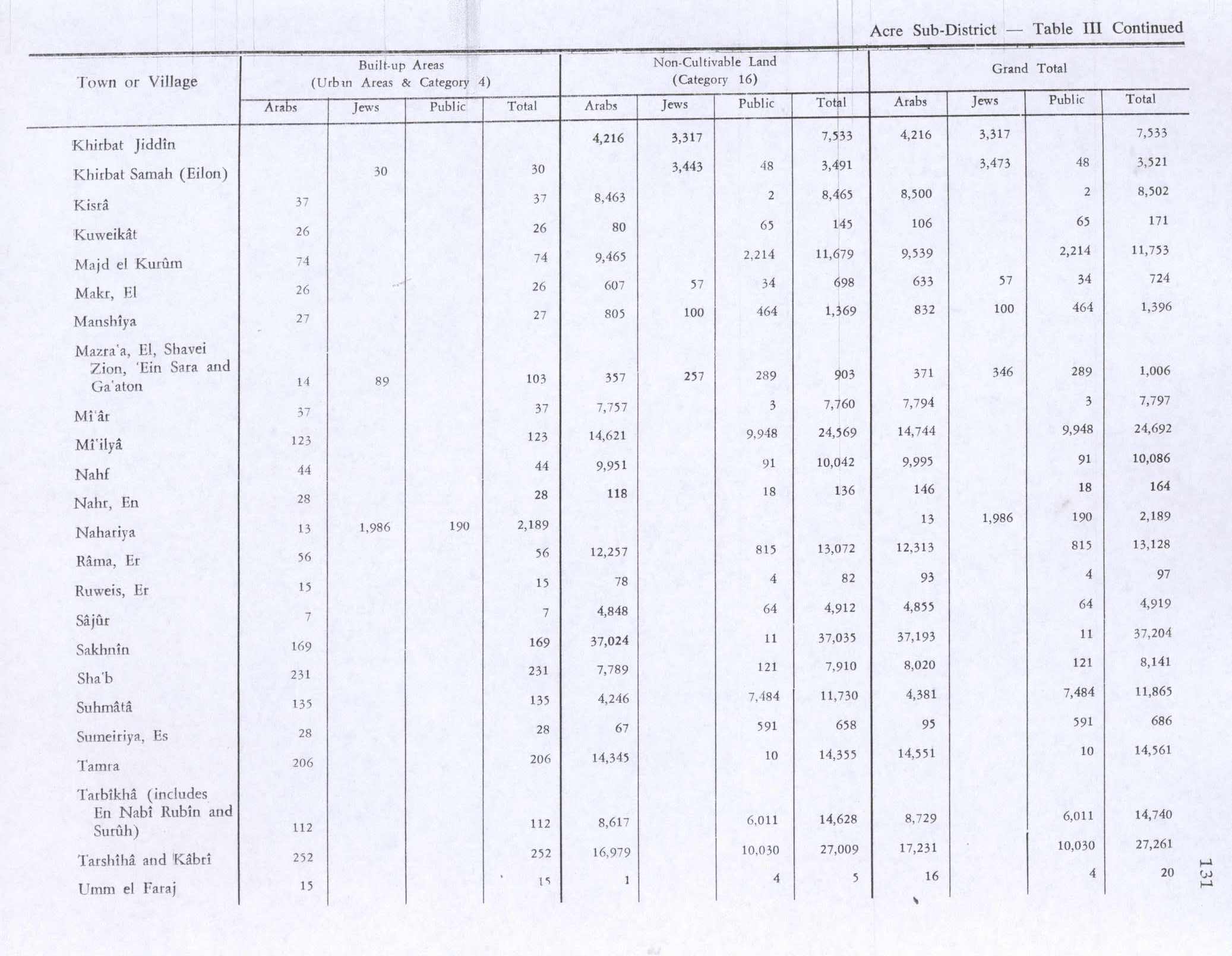
In the 1945 statistics, Sakhnin had 2,600 inhabitants; 2310 Muslims and 290 Christians.[23] The total jurisdiction of the village was 70,192 dunams of land.[24] 3,622 dunams were used for plantations and irrigable land, 29,366 dunams for cereals,[25] while 169 dunams were built-up (urban) land.[26]
State of Israel
During the 1948 Arab-Israeli war, Sakhnin surrendered to Israeli forces on July 18, 1948, during Operation Dekel, but was re-captured by Arab forces shortly afterwards. It finally fell without battle during Operation Hiram, 29–31 October 1948. Many of the inhabitants fled north but some stayed and were not expelled by the Israeli soldiers.[27] The town remained under martial law until 1966.
In 1976, it became the site of the first Land Day marches, in which six Israeli Arabs were killed by Israeli forces during violent protests of government expropriation of 5,000 acres (20 km2) of Arab-owned land near Sakhnin. Later that same year, three more civilians were killed during clashes with the police. Two natives of the city were killed in Jerusalem during the al-Aqsa Intifada in 2000.
The Israeli transcription of the Arabic toponym is an orthographic error, writing Sakhnas instead of Sakhnin.[28]
Sports
In 2003, the town's football club, Bnei Sakhnin, became one of the first Arab teams to play in the Israeli Premier League, the top tier of Israeli football.[29] The following year, the club won the State Cup, and was the first Arab team to do so; consequently, it participated in the UEFA Cup the following season, losing out to Newcastle United. The team received a new home with the 2005 opening of Doha Stadium, funded by the Israeli government and the Qatar National Olympic Committee, whose capital it is named after. The stadium has a capacity of 5,000.[29]
Sakhnin is also the hometown of Abbas Suan, an Israeli international footballer who previously played for Bnei Sakhnin.[citation needed] The town and their soccer team are the subject of the 2010 documentary film After The Cup: Sons of Sakhnin United[30]
On 19 September 2008, Bnei Sakhnin played a game with the Spanish team Deportivo de La Coruña.[31]
Shrines
Sakhnin is home to two shrines:
A-Sheikh Siddiq (Template:Langx) is a shrine located in Sakhnin's historical core, close to the Christian cemetery. It features a Roman-period sarcophagus. The Arabs of Galilee, and the Bedouin of Arab el-Na'im in particular, used to conduct pilgrimages to the shrine in order to make vows and seek for health for themselves and their progeny. The residents of Sakhnin used to beg the saint's forgiveness whenever they went near it out of fear, especially at night. According to a local legend, a-Sheikh Siddiq fought both the Romans and pagans. He was burned by the Romans together with his daughters as he was holding a Torah book. Guerin also referenced another tradition, that claims a-Sheikh Siddiq was interred here next to his wife. Jewish tradition attributes this site to Rabbi Joshua of Sakhnin, an amora who lived in the village in the 4th century CE. Since the 13th century, the shrine has attracted Jewish and Muslim pilgrims alike.[32]
A second shrine, a-Sheikh Ismai'l, is located in the Al-Khalaila clan cemetery in the heart of Sakhnin's western district. This location most likely refers to a local saint rather than the biblical and Quranic Isma'il. Residents of the village claim that one of them had a dream in which the sheikh complained that the sewage water was polluting his tomb. Then, to stop the pollution, this resident constructed a drainage. Every Friday, the women of the Al-Khalaila clan light candles in the tomb.[32]
Notable people
- Mazen Ghnaim, Mayor of Sakhnin 2008―2018, and 2024―present
- Masud Ghnaim, Member of the Knesset, 2009―2019
See also
References
Page Template:Reflist/styles.css has no content.
- ^ a b Page Module:Citation/CS1/styles.css has no content."Regional Statistics". Israel Central Bureau of Statistics. Retrieved 21 March 2026.
- ^ Palmer, 1881, p. 116
- ^ Page Module:Citation/CS1/styles.css has no content."סח'נין" (PDF). Central Bureau of Statistics. Retrieved 15 July 2025.
- ^ Dauphin, 1998, pp. 663-664
- ^ Tsafrir et al, 1994, p. 235
- ^ Tahan, 2005, Sakhnin
- ^ Joshua Schwartz, Peter J. Tomson,'When Rabbi Eliezer was arrested for heresy,' Jewish Studies, an Internet Journal 2012, vol.10, pp.1-37 p.20, n.59
- ^ Schwartz, Tomson, 'When Rabbi Eliezer was arrested for heresy,' 2012 p.6 n.15.
- ^ Richard Bauckham, Jude and the Relatives of Jesus in the Early Church, Bloomsbury Publishing, 2015 Template:Isbn p.116.
- ^ Frankel, 1988, p. 255
- ^ Strehlke, 1869, p. 8, No. 7; cited in Röhricht, 1893, RHH, p. 137, No. 517; cited in Ellenblum, 2003, p. 109, note 16 and Frankel, 1988, p. 255
- ^ Strehlke, 1869, p. 64, No.81; cited Röhricht, 1893, RHH, p. 269, No. 1069; cited in Frankel, 1988, p. 265
- ^ Hütteroth and Abdulfattah 1977, p. 191
- ^ Note that Rhode 1979, p. 6 Script error: No such module "webarchive". writes that the Safad register that Hütteroth and Abdulfattah studied was not from 1595/6, but from 1548/9
- ^ Robinson and Smith 1841, vol. 3, 2nd appendix, p. 133
- ^ Conder and Kitchener 1881, SWP I, p. 286
- ^ Guérin 1880, pp. 469- 471
- ^ Conder and Kitchener 1881, SWP I, pp. 285–286
- ^ Schumacher 1888, p. 174
- ^ Barron, 1923, Table XI, Sub-district of Acre, p.37
- ^ Barron, 1923, Table XVI, p. 50
- ^ Mills, 1932, p. 102
- ^ Government of Palestine, Department of Statistics, 1945, p. 4
- ^ Government of Palestine, Department of Statistics. Village Statistics, April, 1945. Quoted in Hadawi, 1970, p. 41
- ^ Government of Palestine, Department of Statistics. Village Statistics, April, 1945. Quoted in Hadawi, 1970, p. 81
- ^ Government of Palestine, Department of Statistics. Village Statistics, April, 1945. Quoted in Hadawi, 1970, p. 131
- ^ Morris, 1987, p. 226
- ^ Liora Bigon, Amer Dahamshe, 'An anatomy of symbolic power: Israeli road-sign policy and the Palestinian minority,' Environment and Planning D: Society and Space 2014, volume 32, pages 606 – 621 p.613.
- ^ a b Soccer: In Israel and Italy, storied teams rise International Herald Tribune, 15 April 2007
- ^ Page Module:Citation/CS1/styles.css has no content."After the Cup: Sons of Sakhnin United (2009) - IMDb". IMDb.
- ^ El Deportivo de La Coruña vuelve a Europa EL PAÍS, 26 July 2008
- ^ a b Page Module:Citation/CS1/styles.css has no content.Tal, Uri (2023). Muslim Shrines in Eretz Israel: History, Religion, Traditions, Folklore (in עברית). Jerusalem: Yad Izhak Ben-Zvi. pp. 69–70. ISBN 978-965-217-452-9.
Bibliography
Page Template:Refbegin/styles.css has no content.
- Page Module:Citation/CS1/styles.css has no content.Barron, J.B., ed. (1923). Palestine: Report and General Abstracts of the Census of 1922. Government of Palestine.
- Page Module:Citation/CS1/styles.css has no content.Conder, C.R.; Kitchener, H.H. (1881). The Survey of Western Palestine: Memoirs of the Topography, Orography, Hydrography, and Archaeology. Vol. 1. London: Committee of the Palestine Exploration Fund.
- Page Module:Citation/CS1/styles.css has no content.Dauphin, C. (1998). La Palestine byzantine, Peuplement et Populations. BAR International Series 726 (in français). Vol. III : Catalogue. Oxford: Archeopress. ISBN 0-860549-05-4.
- Page Module:Citation/CS1/styles.css has no content.Ellenblum, R. (2003). Frankish Rural Settlement in the Latin Kingdom of Jerusalem. Cambridge University Press. ISBN 9780521521871.
- Page Module:Citation/CS1/styles.css has no content.Frankel, Rafael (1988). "Topographical notes on the territory of Acre in the Crusader period". Israel Exploration Journal. 38 (4): 249–272.
- Page Module:Citation/CS1/styles.css has no content.Government of Palestine, Department of Statistics (1945). Village Statistics, April, 1945.
- Page Module:Citation/CS1/styles.css has no content.Guérin, V. (1880). Description Géographique Historique et Archéologique de la Palestine (in français). Vol. 3: Galilee, pt. 1. Paris: L'Imprimerie Nationale.
- Page Module:Citation/CS1/styles.css has no content.Hadawi, S. (1970). Village Statistics of 1945: A Classification of Land and Area ownership in Palestine. Palestine Liberation Organization Research Center.
- Page Module:Citation/CS1/styles.css has no content.Hütteroth, W.-D.; Abdulfattah, K. (1977). Historical Geography of Palestine, Transjordan and Southern Syria in the Late 16th Century. Erlanger Geographische Arbeiten, Sonderband 5. Erlangen, Germany: Vorstand der Fränkischen Geographischen Gesellschaft. ISBN 3-920405-41-2.
- Page Module:Citation/CS1/styles.css has no content.Mills, E., ed. (1932). Census of Palestine 1931. Population of Villages, Towns and Administrative Areas. Jerusalem: Government of Palestine.
- Page Module:Citation/CS1/styles.css has no content.Morris, B. (1987). The Birth of the Palestinian refugee problem, 1947-1949. Cambridge University Press. ISBN 0-521-33028-9.
- Page Module:Citation/CS1/styles.css has no content.Palmer, E.H. (1881). The Survey of Western Palestine: Arabic and English Name Lists Collected During the Survey by Lieutenants Conder and Kitchener, R. E. Transliterated and Explained by E.H. Palmer. Committee of the Palestine Exploration Fund.
- Page Module:Citation/CS1/styles.css has no content.Rhode, H. (1979). Administration and Population of the Sancak of Safed in the Sixteenth Century (PhD). Columbia University. Archived from the original on 2019-04-20. Retrieved 2017-11-03.
- Page Module:Citation/CS1/styles.css has no content.Robinson, E.; Smith, E. (1841). Biblical Researches in Palestine, Mount Sinai and Arabia Petraea: A Journal of Travels in the year 1838. Vol. 3. Boston: Crocker & Brewster.
- Page Module:Citation/CS1/styles.css has no content.Röhricht, R. (1893). (RRH) Regesta regni Hierosolymitani (MXCVII-MCCXCI) (in Latina). Berlin: Libraria Academica Wageriana.
- Page Module:Citation/CS1/styles.css has no content.Schumacher, G. (1888). "Population list of the Liwa of Akka". Quarterly Statement - Palestine Exploration Fund. 20: 169–191.
- Page Module:Citation/CS1/styles.css has no content.Strehlke, E., ed. (1869). Tabulae Ordinis Theutonici ex tabularii regii Berolinensis codice potissimum. Berlin: Weidmanns.
- Page Module:Citation/CS1/styles.css has no content.Tahan, Hagit (2005-12-29). "Sakhnin". Hadashot Arkheologiyot – Excavations and Surveys in Israel (117).
- Page Module:Citation/CS1/styles.css has no content.Tsafrir, Y.; Leah Di Segni; Judith Green (1994). (TIR): Tabula Imperii Romani: Judaea, Palaestina. Jerusalem: Israel Academy of Sciences and Humanities. ISBN 965-208-107-8.
External links
- Sakhnin municipality site Script error: No such module "webarchive".
- Welcome To Sakhnin
- Survey of Western Palestine, Map 5: IAA, Wikimedia commons
- 'Not quite Zurich' Eretz magazine
Template:Arab localities in Israel footer Lua error in package.lua at line 80: module 'Module:Navbox/configuration' not found. Lua error in package.lua at line 80: module 'Module:Navbox/configuration' not found. Lua error in package.lua at line 80: module 'Module:Authority control/config' not found.